 |
|
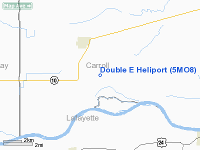
Location & QuickFacts
| FAA Information Effective: | 2008-09-25 |
| Airport Identifier: | 5MO8 |
| Airport Status: | Operational |
| Longitude/Latitude: | 093-39-15.7750W/39-16-10.0610N
-93.654382/39.269461 (Estimated) |
| Elevation: | 670 ft / 204.22 m (Estimated) |
| Land: | 0 acres |
| From nearest city: | 3 nautical miles SE of Norborne, MO |
| Location: | Carroll County, MO |
| Magnetic Variation: | 04E (1985) |
Owner & Manager
| Ownership: | Privately owned |
| Owner: | J Eschenbach |
| Address: | Rt 2
Norborne, MO 64668 |
| Phone number: | 816-587-9059 |
| Address: |
|
Airport Operations and Facilities
| Airport Use: | Private |
| Wind indicator: | No |
| Segmented Circle: | No |
| Control Tower: | No |
| Landing fee charge: | No |
| Sectional chart: | Kansas City |
| Region: | ACE - Central |
| Boundary ARTCC: | ZKC - Kansas City |
| Tie-in FSS: | COU - Columbia |
| FSS on Airport: | No |
| FSS Toll Free: | 1-800-WX-BRIEF |
Runway Information
Helipad H1
| Dimension: | 100 x 100 ft / 30.5 x 30.5 m |
| Surface: | TURF, |
| |
Runway H1 |
Runway |
| Traffic Pattern: | Left | Left |
|
Radio Navigation Aids
| ID |
Type |
Name |
Ch |
Freq |
Var |
Dist |
| PUR | NDB | Marshall | | 371.00 | 03E | 25.4 nm |
| GPH | NDB | Mosby | | 284.00 | 03E | 30.7 nm |
| CHT | NDB | Chillicothe | | 375.00 | 03E | 31.4 nm |
| LXT | NDB | Lesumit | | 263.00 | 04E | 38.3 nm |
| HCK | NDB | Hawks | | 296.00 | 04E | 38.7 nm |
| BZK | NDB | Brookfield | | 383.00 | 03E | 39.0 nm |
| EZZ | NDB | Cameron | | 394.00 | 03E | 39.8 nm |
| DMO | NDB | Sedalia | | 281.00 | 03E | 40.6 nm |
| GKB | NDB | Norge | | 517.00 | 05E | 48.3 nm |
| GQ | NDB | Norge | | 517.00 | 05E | 48.3 nm |
| TRX | NDB | Trenton | | 400.00 | 03E | 48.8 nm |
| VER | NDB | Viertel | | 347.00 | 02E | 49.2 nm |
| SZL | TACAN | Whiteman | 035X | | 04E | 32.4 nm |
| BQS | VOR/DME | Braymer | 049X | 111.20 | 03E | 24.0 nm |
| RIS | VOR/DME | Riverside | 051X | 111.40 | 05E | 44.8 nm |
| ANX | VORTAC | Napoleon | 087X | 114.00 | 07E | 24.5 nm |
| MKC | VOT | Kansas City Downtown | | 108.60 | | 44.8 nm |
Remarks
- PRVDD APCH/DEP PATHS ARE MAINTD FOR A MIN 8:1 GLIDE SLOPE & TRSNL SFC MAINTD FOR A 2:1 SLOPE.
Images and information placed above are from
http://www.airport-data.com/airport/5MO8/
We thank them for the data!
| General Info
|
| Country |
United States
|
| State |
MISSOURI
|
| FAA ID |
5MO8
|
| Latitude |
39-16-10.061N
|
| Longitude |
093-39-15.775W
|
| Elevation |
670 feet
|
| Near City |
NORBORNE
|
We don't guarantee the information is fresh and accurate. The data may
be wrong or outdated.
For more up-to-date information please refer to other sources.
|
|


