 |
|
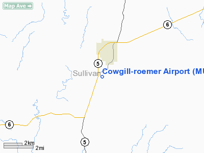
Location & QuickFacts
| FAA Information Effective: | 2008-09-25 |
| Airport Identifier: | MU38 |
| Airport Status: | Operational |
| Longitude/Latitude: | 093-07-52.7510W/40-10-42.0670N
-93.131320/40.178352 (Estimated) |
| Elevation: | 900 ft / 274.32 m (Estimated) |
| Land: | 10 acres |
| From nearest city: | 1 nautical miles S of Milan, MO |
| Location: | Sullivan County, MO |
| Magnetic Variation: | 04E (1985) |
Owner & Manager
| Ownership: | Privately owned |
| Owner: | William W./elizabeth Cowgill |
| Address: | 2503 W Black Oak Dr
Columbia, MO 65203-6622 |
| Phone number: | 816-265-3544
OR CALL 314-442-4444 |
| Manager: | H. M. Cowgill |
| Address: | 5505 N. 63 Highway
Columbia, MO 65202 |
| Phone number: | 314-442-4444
OR CALL 314-751-9786. |
Airport Operations and Facilities
| Airport Use: | Private |
| Wind indicator: | Yes |
| Segmented Circle: | No |
| Control Tower: | No |
| Landing fee charge: | No |
| Sectional chart: | Kansas City |
| Region: | ACE - Central |
| Boundary ARTCC: | ZKC - Kansas City |
| Tie-in FSS: | COU - Columbia |
| FSS on Airport: | No |
| FSS Toll Free: | 1-800-WX-BRIEF |
Runway Information
Runway 09/27
| Dimension: | 2600 x 50 ft / 792.5 x 15.2 m |
| Surface: | TURF, |
| |
Runway 09 |
Runway 27 |
| Traffic Pattern: | Left | Right |
|
Radio Navigation Aids
| ID |
Type |
Name |
Ch |
Freq |
Var |
Dist |
| TRX | NDB | Trenton | | 400.00 | 03E | 22.0 nm |
| BZK | NDB | Brookfield | | 383.00 | 03E | 24.9 nm |
| CHT | NDB | Chillicothe | | 375.00 | 03E | 29.3 nm |
| TVK | NDB | Centerville | | 290.00 | 04E | 32.4 nm |
| BEX | NDB | Bloomfield | | 269.00 | 02E | 46.8 nm |
| MCM | VOR/DME | Macon | 076X | 112.90 | 06E | 43.5 nm |
| BQS | VOR/DME | Braymer | 049X | 111.20 | 03E | 47.5 nm |
| IRK | VORTAC | Kirksville | 093X | 114.60 | 06E | 24.9 nm |
| LMN | VORTAC | Lamoni | 114X | 116.70 | 07E | 45.8 nm |
Remarks
- TWR 300' HIGH 2.2NM NORTH; TWR 100' HIGH .2NM NORTH; TWR 75' HIGH 1.5NM NORTH; TWR 150' HIGH 1.4NM NORTH; TWR 100' HIGH 1.4NM NORTH.
- PROVIDED APPROACHES ARE MAINTAINED FOR A 20:1 GLIDE SLOPE AND TRANSITIONAL SURFACES ARE MAINTAINED FOR A 7:1 SLOPE.
Images and information placed above are from
http://www.airport-data.com/airport/MU38/
We thank them for the data!
| General Info
|
| Country |
United States
|
| State |
MISSOURI
|
| FAA ID |
MU38
|
| Latitude |
40-10-42.067N
|
| Longitude |
093-07-52.751W
|
| Elevation |
900 feet
|
| Near City |
MILAN
|
We don't guarantee the information is fresh and accurate. The data may
be wrong or outdated.
For more up-to-date information please refer to other sources.
|
|


