|
|
Charles B. Wheeler Downtown Airport |
| Charles B. Wheeler Downtown Airport |
 |
| FAA airport diagram |
| IATA: MKC – ICAO: KMKC – FAA LID: MKC |
| Summary |
| Airport type |
Public |
| Owner |
Kansas City Aviation Department |
| Operator |
Kansas City Aviation Department |
| Serves |
Kansas City, Missouri |
| Location |
Kansas City, Missouri |
| Elevation AMSL |
759 ft / 231 m |
| Coordinates |
39°07′24″N 094°35′34″W / 39.12333°N 94.59278°W / 39.12333; -94.59278 |
| Website |
www.flyMKC.com |
| Runways |
| Direction |
Length |
Surface |
| ft |
m |
| 1/19 |
7,002 |
2,134 |
Concrete |
| 3/21 |
5,050 |
1,539 |
Asphalt |
| Statistics (2006) |
| Aircraft operations |
83,219 |
| Based aircraft |
229 |
| Source: Federal Aviation Administration |
Charles B. Wheeler Downtown Airport (IATA: MKC, ICAO: KMKC, FAA LID: MKC), also known as Kansas City Downtown Airport, is a public airport located in Kansas City, Clay County, Missouri, United States. This airport is publicly owned by City of Kansas City. History
 | |
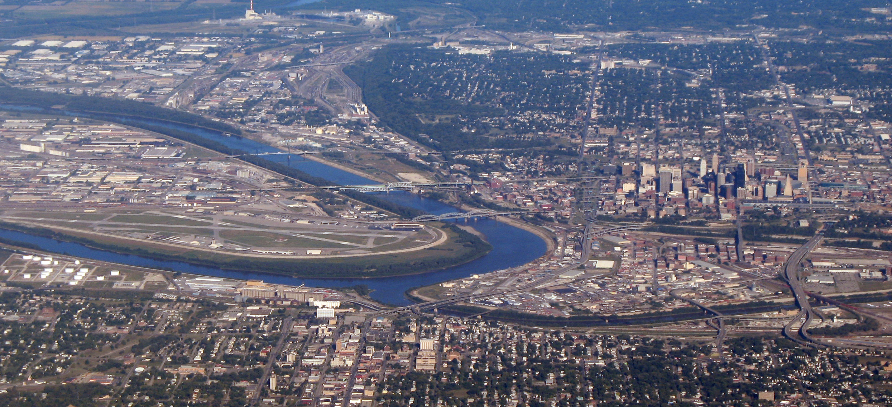
The city considered calling the airport "Peninsula Field" because of the sharp bend in the Missouri River around the airport |
 | |
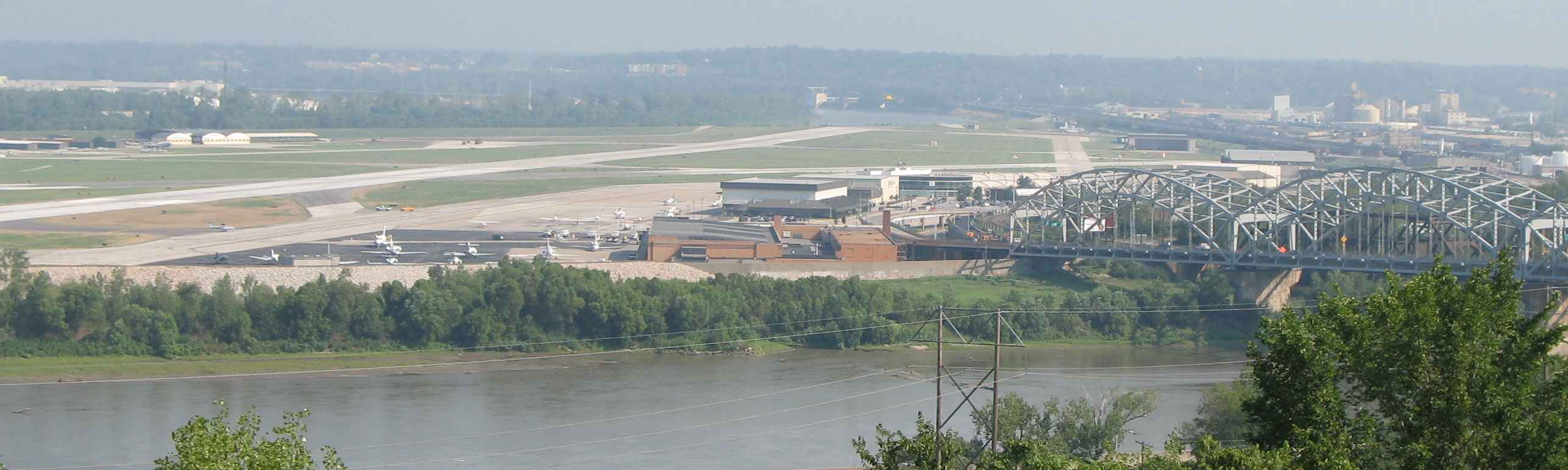
The airport from Quality Hill. The Broadway Bridge (Kansas City) is on the right. The Fairfax Assembly plant (the former Fairfax Airport) is the big building across the Missouri River on the left. |
This airport replaced Richards Field as Kansas City's main airport. It was dedicated as New Richards Field in 1927 by Charles Lindbergh. It was quickly renamed Kansas City Municipal Airport. Its most prominent tenant was TWA which was headquartered in Kansas City because of its central location. The airport was built in the Missouri River bottoms next to the rail tracks at the Hannibal Bridge. At the time air travel was considered to be handled in conjunction with rail traffic.
The airport had limited area for expansion (in fact, Fairfax Airport directly across the Missouri River in Kansas City, Kansas was actually bigger area wise before it closed). Airplanes had to avoid the 200-foot (60 m) Quality Hill and the Downtown Kansas City skyline at the south end of the main runway. In the early 1960s, an FAA memo called it "the most dangerous major airport in the country" and urged that no further federal funds be spent on it. Kansas City replaced the airport in 1972 with Kansas City International Airport.
The downtown airport has been renamed for Charles Wheeler who was mayor when Kansas City International opened. Richards Road which serves the airport is named for John Francisco Richards II, a Kansas City airman killed in World War I (and whose name was also applied to Richards Field and Richards-Gebaur Air Force Base).
Despite the concerns about the airport's being unsafe, Air Force One frequently uses it during Presidential visits. [1][2]
Today, the airport is used chiefly for corporate and recreational aviation. Its location just north of the downtown business center provides excellent highway access.
It is home to the Airline History Museum which focuses extensively on TWA history.
Facilities
Charles B. Wheeler Downtown Airport covers an area of 700 acres (283 ha) which contains two runways:
- Runway 1/19: 7,002 x 150 ft (2,134 x 46 m), Surface: Concrete; EMAS at south end
- Runway 3/21: 5,050 x 150 ft (1,539 x 46 m), Surface: Asphalt
As of October 10, 2006, construction on runway 1-19 is complete and both runways are in use to their full length.
Taxiway H was at one time part of runway 17/35. This runway was closed after an FAA decision on the amount of required separation between terminal buildings and the runway.
Kansas City, MO Aviation Department announced plans on October 17, 2006 to build a $20 million aircraft hangar complex at the Charles B. Wheeler Downtown Airport including: 122 T-hangars, 13 box hangars, a 40,000-square-foot (4,000 m) terminal building with offices, a pilots' lounge, meeting rooms and a destination restaurant.
Incidents
- On March 31, 1931, Notre Dame Coach Knute Rockne was killed on Transcontinental & Western Air Flight 599 from Kansas City to Los Angeles when the Fokker Trimotor broke up in a storm over Bazaar, Kansas. Rockne had been visiting his sons at Pembroke-Country Day School. The crash nearly put TWA out of business because it highlighted its aging fleet. The crash ushered in a golden era for TWA when it replaced the aging fleet with state-of-the-art aircraft.
- On January 16, 1942, Transcontinental & Western Air Flight 3 to Los Angeles impacted Mount Potosi in Nevada after a refueling stop in Las Vegas killing 22. Actress Carole Lombard was among the victims.
- On June 30, 1956, Trans World Airlines Flight 2, a Lockheed Super Constellation, was headed for Kansas City Downtown Airport. Over the Grand Canyon it collided with a United Airlines Douglas DC-7 killing all 128 people on both planes.
- On May 22, 1962 Continental Airlines Flight 11 en route from Chicago O'Hare International Airport to Kansas City Downtown Airport exploded over Unionville, Missouri. All 45 on board were killed.
- On July 1, 1965, Continental Airlines Flight 12 from Los Angeles International Airport landed in heavy rain and was unable to stop due to hydroplaning. It impacted a blast mound and broke into 3 pieces but all 66 on board survived.
- On August 6, 1966, Braniff Airways Flight 250 left Kansas City Downtown Airport headed for Omaha and crashed near Falls City, Nebraska killing all 42 on board.
- The airport is built on the north side of the confluence of the Kansas River and Missouri River. Levees protected the airport relatively well during the Great Flood of 1951 and the Great Flood of 1993 although there were issues of standing water. The 1951 flood devastated the Fairfax airport and caused Kansas City to build what would become Kansas City International Airport away from the river to keep the TWA overhaul base in the area after it had been destroyed in the flood at Fairfax.
The above content comes from Wikipedia and is published under free licenses – click here to read more.

Location & QuickFacts
| FAA Information Effective: | 2008-09-25 |
| Airport Identifier: | MKC |
| Airport Status: | Operational |
| Longitude/Latitude: | 094-35-33.9000W/39-07-23.7000N
-94.592750/39.123250 (Estimated) |
| Elevation: | 759 ft / 231.34 m (Surveyed) |
| Land: | 700 acres |
| From nearest city: | 0 nautical miles NW of Kansas City, MO |
| Location: | Clay County, MO |
| Magnetic Variation: | 05E (1985) |
Owner & Manager
| Ownership: | Publicly owned |
| Owner: | City Of Kansas City |
| Address: | 414 E. 12th St
Kansas City, MO 64106 |
| Phone number: | 816-513-3600 |
| Manager: | Michael E. Roper |
| Address: | 300 Richards Road
Kansas City, MO 64116 |
| Phone number: | 816-513-0805 |
Airport Operations and Facilities
| Airport Use: | Open to public |
| Wind indicator: | Yes |
| Segmented Circle: | No |
| Control Tower: | Yes |
| Lighting Schedule: | DUSK-DAWN |
| Beacon Color: | Clear-Green (lighted land airport) |
| Landing fee charge: | No |
| Sectional chart: | Kansas City |
| Region: | ACE - Central |
| Boundary ARTCC: | ZKC - Kansas City |
| Tie-in FSS: | COU - Columbia |
| FSS on Airport: | No |
| FSS Toll Free: | 1-800-WX-BRIEF |
| NOTAMs Facility: | MKC (NOTAM-d service avaliable) |
| Certification type/date: | IV A U 06/199
ARPT CLSD TO ACR OPNS WITH MORE THAN 30 PSGR SEATS EXCP 24 HR PPR CALL AMGR (816) 513-0800. AIR CARRIER OPS NOT AUTHORIZED IN EXCESS OF 15 MINUTES BFR OR AFT SKED ARR OR DEP TIMES W/O PRIOR COORDINATION WITH AMGR CONFIRMING ARFF AVBL PRIOR TO LNDG OR TKOF. |
| Federal Agreements: | NGY |
Airport Communications
Airport Services
| Fuel available: | 100LLA |
| Airframe Repair: | MAJOR |
| Power Plant Repair: | MAJOR |
| Bottled Oxygen: | HIGH/LOW |
| Bulk Oxygen: | HIGH/LOW |
Runway Information
Runway 01/19
| Dimension: | 7002 x 150 ft / 2134.2 x 45.7 m |
| Surface: | CONC, Good Condition |
| Surface Treatment: | Saw-cut or plastic Grooved |
| Weight Limit: | Single wheel: 86000 lbs.
Dual wheel: 171000 lbs.
Dual tandem wheel: 342000 lbs. |
| Edge Lights: | High |
| |
Runway 01 |
Runway 19 |
| Longitude: | 094-35-42.9820W | 094-35-23.4645W |
| Latitude: | 39-06-53.8375N | 39-08-01.3446N |
| Elevation: | 748.00 ft | 759.00 ft |
| Alignment: | 13 | 127 |
| ILS Type: | | ILS
|
| Traffic Pattern: | Left | Left |
| Markings: | Precision instrument, Good Condition | Precision instrument, Good Condition |
| Crossing Height: | 66.00 ft | 46.00 ft |
| Displaced threshold: | 200.00 ft | 200.00 ft |
| VASI: | 4-box on left side | 4-box on left side |
| Visual Glide Angle: | 3.70° | 3.00° |
| RVR Equipment: | | touchdown |
| Approach lights: | RAIL | MALSF |
| Runway End Identifier: | Yes | No |
| Obstruction: | 38 ft tree, 747.0 ft from runway, 571 ft right of centerline, 20:1 slope to clear | 20 ft road, 700.0 ft from runway, 150 ft left of centerline, 25:1 slope to clear
ROAD & FENCE 0-200' FM THR. |
| Decleard distances: | Take off run available 7001.00 ft
Take off distance available 7001.00 ft
Actual stop distance available 6001.00 ft
Landing distance available 5801.00 ft
| Take off run available 7001.00 ft
Take off distance available 7001.00 ft
Actual stop distance available 6401.00 ft
Landing distance available 6201.00 ft
|
|
Runway 03/21
| Dimension: | 5050 x 150 ft / 1539.2 x 45.7 m |
| Surface: | ASPH, Good Condition |
| Surface Treatment: | Saw-cut or plastic Grooved |
| Weight Limit: | Single wheel: 48000 lbs.
Dual wheel: 73000 lbs.
Dual tandem wheel: 136000 lbs. |
| Edge Lights: | High |
| |
Runway 03 |
Runway 21 |
| Longitude: | 094-35-54.6523W | 094-35-14.8194W |
| Latitude: | 39-06-58.6638N | 39-07-37.7598N |
| Elevation: | 743.00 ft | 743.00 ft |
| Alignment: | 38 | 127 |
| ILS Type: | ILS
| |
| Traffic Pattern: | Left | Left |
| Markings: | Precision instrument, Good Condition | Precision instrument, Good Condition |
| Crossing Height: | 50.00 ft | 57.00 ft |
| Displaced threshold: | 500.00 ft | 699.00 ft |
| VASI: | 4-box on left side | 4-box on left side |
| Visual Glide Angle: | 3.00° | 3.30° |
| RVR Equipment: | touchdown | |
| Runway End Identifier: | | Yes |
| Obstruction: | 20 ft levee, 450.0 ft from runway, 125 ft left of centerline, 12:1 slope to clear
APCH RATIO AT DSPLCD THR 47:1. | 37 ft rr, 225.0 ft from runway, 100 ft left of centerline
APCH RATIO AT DSPLCD THR 24:1.
ROAD & RR 0-200' FM THR. |
| Decleard distances: | Take off run available 5050.00 ft
Take off distance available 5050.00 ft
Actual stop distance available 5050.00 ft
Landing distance available 4550.00 ft
| Take off run available 5050.00 ft
Take off distance available 5050.00 ft
Actual stop distance available 5050.00 ft
Landing distance available 4351.00 ft
|
|
Radio Navigation Aids
| ID |
Type |
Name |
Ch |
Freq |
Var |
Dist |
| GKB | NDB | Norge | | 517.00 | 05E | 4.7 nm |
| GQ | NDB | Norge | | 517.00 | 05E | 4.7 nm |
| DO | NDB | Dotte | | 359.00 | 05E | 9.4 nm |
| LXT | NDB | Lesumit | | 263.00 | 04E | 14.2 nm |
| GPH | NDB | Mosby | | 284.00 | 03E | 18.9 nm |
| EZZ | NDB | Cameron | | 394.00 | 03E | 39.3 nm |
| AZN | NDB | Amazon | | 233.00 | 06E | 48.0 nm |
| RIS | VOR/DME | Riverside | 051X | 111.40 | 05E | 0.2 nm |
| OJC | VOR/DME | Johnson County | 077X | 113.00 | 06E | 18.3 nm |
| BQS | VOR/DME | Braymer | 049X | 111.20 | 03E | 45.2 nm |
| MCI | VORTAC | Kansas City | 079Y | 113.25 | 05E | 11.8 nm |
| ANX | VORTAC | Napoleon | 087X | 114.00 | 07E | 21.7 nm |
| TOP | VORTAC | Topeka | 125X | 117.80 | 05E | 44.6 nm |
| MKC | VOT | Kansas City Downtown | | 108.60 | | 0.2 nm |
Remarks
- FLOCKS OF PIGEONS INVOF DEP EOR 03.
- SUN GLARE MY INTERFERE WITH SIGN & PAVEMENT MKGS ON E/W TWYS.
- RY 03/21 VFR E TFC PAT: DEPARTING RY 03 RIGHT TFC ATTAIN TFC PAT ALT PRIOR TO TURNING CROSSWIND. LDG RY 21 MAINTAIN TFC PAT ALT UNTIL PASSING N OF MISSOURI RIVER.
- CAT C/D OPN N/A RY 03/21.
- CRANE 98 FT AGL 3300 FT SOUTH AER TWY 3 DAYLIGHT HRS. MON-FRI.
- WATERFOWL ON & INVOF ARPT.
- APRONS AT HANGER 6A & 9 CLSD TO AIR CARRIER OPNS.
Images and information placed above are from
http://www.airport-data.com/airport/MKC/
We thank them for the data!
| General Info
|
| Country |
United States
|
| State |
MISSOURI
|
| FAA ID |
MKC
|
| Latitude |
39-07-23.668N
|
| Longitude |
094-35-33.846W
|
| Elevation |
759 feet
|
| Near City |
KANSAS CITY
|
We don't guarantee the information is fresh and accurate. The data may
be wrong or outdated.
For more up-to-date information please refer to other sources.
|
|