 |
|
Cape Girardeau Regional Airport |
| Cape Girardeau Regional Airport |
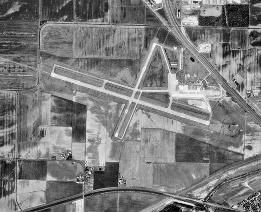 |
| USGS aerial image, 22 March 1996 |
| IATA: CGI – ICAO: KCGI – FAA LID: CGI |
| Summary |
| Airport type |
Public |
| Owner |
City of Cape Girardeau |
| Serves |
Cape Girardeau, Missouri |
| Elevation AMSL |
342 ft / 104 m |
| Coordinates |
37°13′31″N 089°34′15″W / 37.22528°N 89.57083°W / 37.22528; -89.57083 |
| Website |
www.CapeAirport.com |
| Runways |
| Direction |
Length |
Surface |
| ft |
m |
| 10/28 |
6,499 |
1,981 |
Concrete |
| 2/20 |
3,996 |
1,218 |
Asphalt/Concrete |
| Statistics (2009) |
| Aircraft operations |
28,545 |
| Based aircraft |
50 |
| Source: Federal Aviation Administration |
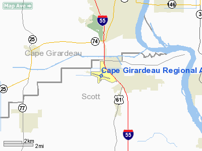
Cape Girardeau Regional Airport (IATA: CGI, ICAO: KCGI, FAA LID: CGI) is a city-owned, public-use airport located five nautical miles (9 km) southwest of the central business district of Cape Girardeau, a city in Scott County, Missouri, United States. It is used for general aviation, and has scheduled service by American Airlines partner Cape Air with subsidized Essential Air Service program flights to Lambert-St. Louis International Airport. History
Opened in 1943, the airport was constructed by the United States Army Air Force. Known as Harris Army Airfield, the airfield was a primary (stage 1) pilot training airfield assigned to AAF Flying Training Command, Southeast Training Center (later Eastern Flying Training Command). It was operated under contract to Cape Institute of Aeronautics, Inc., with the civil instructors under the USAAF 73d Flying Training Detachment. Fairchild PT-19s were the primary trainer at the airfield.
Contract flying training was short at the airfield, the school closing during the late summer of 1944 with the drawdown of AAFTC's pilot training program. The airfield was turned over to civil control at the end of the war though the War Assets Administration (WAA).
Facilities and aircraft
Cape Girardeau Regional Airport covers an area of 557 acres (225 ha) at an elevation of 342 feet (104 m) above mean sea level. It has two runways: 10/28 is 6,499 by 150 feet (1,981 x 46 m) with a concrete surface and 2/20 is 3,996 by 100 feet (1,218 x 30 m) with an asphalt/concrete surface.
For the 12-month period ending December 31, 2009, the airport had 28,545 aircraft operations, an average of 78 per day: 90% general aviation, 7% scheduled commercial, 3% military. At that time there were 50 aircraft based at this airport: 74% single-engine, 16% multi-engine, 6% jet and 4% helicopter.
Airlines and destinations
| Airlines |
Destinations |
| Cape Air |
St. Louis |
The above content comes from Wikipedia and is published under free licenses – click here to read more.
Location & QuickFacts
| FAA Information Effective: | 2008-09-25 |
| Airport Identifier: | CGI |
| Airport Status: | Operational |
| Longitude/Latitude: | 089-34-14.7060W/37-13-31.1410N
-89.570752/37.225317 (Estimated) |
| Elevation: | 342 ft / 104.24 m (Surveyed) |
| Land: | 557 acres |
| From nearest city: | 5 nautical miles SW of Cape Girardeau, MO |
| Location: | Scott County, MO |
| Magnetic Variation: | 01E (1995) |
Owner & Manager
| Ownership: | Publicly owned |
| Owner: | City Of Cape Girardeau |
| Address: | City Hall, 401 Independence
Cape Girardeau, MO 63701 |
| Phone number: | 573-334-1212 |
| Manager: | Mr Bruce W Loy |
| Address: | Po Box 617
Cape Girardeau, MO 63702 |
| Phone number: | 573-334-6230 |
Airport Operations and Facilities
| Airport Use: | Open to public |
| Wind indicator: | Yes |
| Segmented Circle: | No |
| Control Tower: | Yes |
| Lighting Schedule: | DUSK-DAWN
ACTVT MALSR RY 10 AND ODALS RY 28 - CTAF. |
| Beacon Color: | Clear-Green (lighted land airport) |
| Landing fee charge: | No |
| Sectional chart: | St Louis |
| Region: | ACE - Central |
| Boundary ARTCC: | ZME - Memphis |
| Tie-in FSS: | STL - Saint Louis |
| FSS Toll Free: | 1-800-WX-BRIEF |
| NOTAMs Facility: | CGI (NOTAM-d service avaliable) |
| Certification type/date: | III A S 05/19
AS A CLASS III ARPT, CLSD TO ACR OPNS WITH MORE THAN 30 PSGR SEATS. CONTACT AMGR 573-334-6230 FOR INFO. |
| Federal Agreements: | NGRY |
Airport Communications
| CTAF: | 119.000 |
| Unicom: | 122.950 |
Airport Services
| Fuel available: | 100LLA |
| Airframe Repair: | MAJOR |
| Power Plant Repair: | MAJOR |
| Bottled Oxygen: | HIGH |
| Bulk Oxygen: | NONE |
Runway Information
Runway 02/20
| Dimension: | 3996 x 100 ft / 1218.0 x 30.5 m |
| Surface: | ASPH-CONC, Fair Condition |
| Weight Limit: | Single wheel: 45000 lbs.
Dual wheel: 60000 lbs.
Dual tandem wheel: 100000 lbs. |
| Edge Lights: | Medium |
| |
Runway 02 |
Runway 20 |
| Longitude: | 089-34-22.1760W | 089-34-04.3130W |
| Latitude: | 37-13-14.8990N | 37-13-51.7300N |
| Elevation: | 342.00 ft | 336.00 ft |
| Alignment: | 21 | 127 |
| Traffic Pattern: | Left | Left |
| Markings: | Non-precision instrument, Good Condition | Non-precision instrument, Good Condition |
| Crossing Height: | 52.00 ft | 45.00 ft |
| VASI: | 4-box on left side | 4-box on left side |
| Visual Glide Angle: | 4.00° | 3.00° |
| Obstruction: | 70 ft tree, 1500.0 ft from runway, 450 ft left of centerline, 18:1 slope to clear | , 50:1 slope to clear |
|
Runway 10/28
| Dimension: | 6499 x 150 ft / 1980.9 x 45.7 m |
| Surface: | CONC, Good Condition |
| Surface Treatment: | Saw-cut or plastic Grooved |
| Weight Limit: | Single wheel: 93000 lbs.
Dual wheel: 125000 lbs.
Dual tandem wheel: 215000 lbs. |
| Edge Lights: | High |
| |
Runway 10 |
Runway 28 |
| Longitude: | 089-34-54.2640W | 089-33-36.9450W |
| Latitude: | 37-13-38.5540N | 37-13-21.0520N |
| Elevation: | 338.00 ft | 341.00 ft |
| Alignment: | 106 | 127 |
| ILS Type: | ILS
| |
| Traffic Pattern: | Left | Left |
| Markings: | Precision instrument, Fair Condition | Non-precision instrument, Fair Condition |
| Crossing Height: | 0.00 ft | 38.00 ft |
| VASI: | | 4-box on left side |
| Visual Glide Angle: | 0.00° | 3.00° |
| Approach lights: | MALSR | ODALS |
| Obstruction: | , 50:1 slope to clear | 160 ft tree, 5600.0 ft from runway, 1100 ft right of centerline, 33:1 slope to clear |
|
Radio Navigation Aids
| ID |
Type |
Name |
Ch |
Freq |
Var |
Dist |
| CIR | NDB | Cairo | | 397.00 | 00E | 19.3 nm |
| CHQ | NDB | Charleston | | 208.00 | 01E | 25.1 nm |
| DXE | NDB | Dexter | | 423.00 | 00E | 31.7 nm |
| BDD | NDB | Bellgrade | | 254.00 | 00E | 43.4 nm |
| PJY | NDB | Pinckneyville | | 215.00 | 00E | 46.1 nm |
| FD | NDB | Earli | | 278.00 | 03E | 49.4 nm |
| CGI | VOR/DME | Cape Girardeau | 076X | 112.90 | 01E | 0.2 nm |
| MWA | VOR/DME | Marion | 041X | 110.40 | 04E | 41.5 nm |
| CNG | VORTAC | Cunningham | 078X | 113.10 | 03E | 37.5 nm |
| FAM | VORTAC | Farmington | 104X | 115.70 | 01E | 41.6 nm |
| MAW | VORTAC | Malden | 049X | 111.20 | 03E | 43.5 nm |
Remarks
- NORTHERN 100 FT TWY 'C' NOT VISIBLE FM CONTROL TOWER.
Images and information placed above are from
http://www.airport-data.com/airport/CGI/
We thank them for the data!
| General Info
|
| Country |
United States
|
| State |
MISSOURI
|
| FAA ID |
CGI
|
| Latitude |
37-13-31.141N
|
| Longitude |
089-34-14.706W
|
| Elevation |
342 feet
|
| Near City |
CAPE GIRARDEAU
|
We don't guarantee the information is fresh and accurate. The data may
be wrong or outdated.
For more up-to-date information please refer to other sources.
|
|


