 |
|
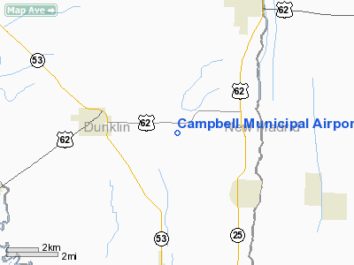
Campbell Municipal Airport |
Location & QuickFacts
| FAA Information Effective: | 2008-09-25 |
| Airport Identifier: | 34M |
| Airport Status: | Operational |
| Longitude/Latitude: | 090-00-56.5000W/36-29-09.8000N
-90.015694/36.486056 (Estimated) |
| Elevation: | 284 ft / 86.56 m (Surveyed) |
| Land: | 740 acres |
| From nearest city: | 3 nautical miles E of Campbell, MO |
| Location: | Dunklin County, MO |
| Magnetic Variation: | 02E (1985) |
Owner & Manager
| Ownership: | Publicly owned |
| Owner: | City Of Campbell |
| Address: | 302 W Grand
Campbell, MO 63933 |
| Phone number: | 573-246-2541 |
| Manager: | Raymond Gunter
MAYOR. |
| Address: | 302 W Grand
Campbell, MO 63933 |
| Phone number: | 573-246-2541 |
Airport Operations and Facilities
| Airport Use: | Open to public |
| Wind indicator: | Yes |
| Segmented Circle: | Yes |
| Control Tower: | No |
| Lighting Schedule: | DUSK-DAWN |
| Landing fee charge: | No |
| Sectional chart: | St Louis |
| Region: | ACE - Central |
| Boundary ARTCC: | ZME - Memphis |
| Tie-in FSS: | STL - Saint Louis |
| FSS on Airport: | No |
| FSS Toll Free: | 1-800-WX-BRIEF |
| NOTAMs Facility: | STL (NOTAM-d service avaliable) |
| Federal Agreements: | P |
Airport Communications
Airport Services
Runway Information
Runway 18/36
| Dimension: | 3000 x 50 ft / 914.4 x 15.2 m |
| Surface: | ASPH, Good Condition |
| Edge Lights: | Non-standard lighting system
RY 18/36 NSTD LIRL; RY 18 THLD LGTS INCORRECTLY SPACED. |
| |
Runway 18 |
Runway 36 |
| Longitude: | 090-00-56.2700W | 090-00-56.7400W |
| Latitude: | 36-29-24.6500N | 36-28-54.9800N |
| Traffic Pattern: | Left | Left |
| Markings: | Basic, Good Condition
MARKINGS FADED. | Basic, Good Condition
MARKINGS FADED. |
| Obstruction: | 15 ft road, 580.0 ft from runway, 25:1 slope to clear
+1-3 FT CROPS, 0-200 FT FM RWY END, 100-125 FT L. | , 50:1 slope to clear
+1-3 FT CROPS, 0-200 FT FM RWY END, 100-125 FT L & R. |
|
Radio Navigation Aids
| ID |
Type |
Name |
Ch |
Freq |
Var |
Dist |
| TKX | NDB | Kennett | | 358.00 | 00E | 15.5 nm |
| DXE | NDB | Dexter | | 423.00 | 00E | 18.5 nm |
| FD | NDB | Earli | | 278.00 | 03E | 18.7 nm |
| IUI | NDB | Hicks | | 350.00 | 01E | 34.1 nm |
| PGR | NDB | Paragould | | 383.00 | 01E | 35.0 nm |
| MXA | NDB | Manila | | 282.00 | 01E | 36.4 nm |
| CHQ | NDB | Charleston | | 208.00 | 01E | 38.4 nm |
| DNT | NDB | Nally Dunston | | 343.00 | 01W | 41.8 nm |
| TNZ | NDB | Lawrence County | | 227.00 | 01E | 47.1 nm |
| BPW | NDB | Osceola | | 239.00 | 02E | 47.7 nm |
| GOJ | VOR | Gosnell | | 111.80 | 01E | 32.4 nm |
| JBR | VOR/DME | Jonesboro | 023X | 108.60 | 02E | 46.1 nm |
| CGI | VOR/DME | Cape Girardeau | 076X | 112.90 | 01E | 49.4 nm |
| MAW | VORTAC | Malden | 049X | 111.20 | 03E | 6.5 nm |
| DYR | VORTAC | Dyersburg | 115X | 116.80 | 03E | 44.0 nm |
Remarks
- CROP DUSTING ACFT ON & INVOF ARPT.
- ALL APRON & TWY PVMT IN POOR CNDTN WITH NUMEROUS CRACKS, LOOSE AGGREGRATE, FOD.
- EXISTED PRIOR TO 1959.
Images and information placed above are from
http://www.airport-data.com/airport/34M/
We thank them for the data!
| General Info
|
| Country |
United States
|
| State |
MISSOURI
|
| FAA ID |
34M
|
| Latitude |
36-29-10.215N
|
| Longitude |
090-00-30.332W
|
| Elevation |
284 feet
|
| Near City |
CAMPBELL
|
We don't guarantee the information is fresh and accurate. The data may
be wrong or outdated.
For more up-to-date information please refer to other sources.
|
|


