 |
|
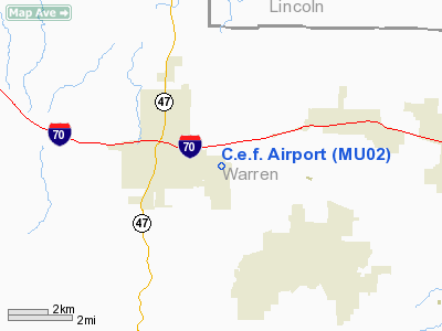
Location & QuickFacts
| FAA Information Effective: | 2008-09-25 |
| Airport Identifier: | MU02 |
| Airport Status: | Operational |
| Longitude/Latitude: | 091-06-12.5270W/38-48-35.1720N
-91.103480/38.809770 (Estimated) |
| Elevation: | 638 ft / 194.46 m (Estimated) |
| Land: | 0 acres |
| From nearest city: | 2 nautical miles E of Warrenton, MO |
| Location: | Warren County, MO |
| Magnetic Variation: | 02E (1985) |
Owner & Manager
| Ownership: | Privately owned |
| Owner: | Child Evangelism Fellowship |
| Address: | Po Box 348
Warrenton, MO 63387 |
| Phone number: | 573-456-4321 |
| Manager: | Mark John Yeadon |
| Address: | 507 Pike St
Warrington, MO 63383 |
| Phone number: | 314-456-4321 |
Airport Operations and Facilities
| Airport Use: | Private |
| Wind indicator: | No |
| Segmented Circle: | No |
| Control Tower: | No |
| Landing fee charge: | No |
| Sectional chart: | Kansas City |
| Region: | ACE - Central |
| Boundary ARTCC: | ZKC - Kansas City |
| Tie-in FSS: | STL - Saint Louis |
| FSS on Airport: | No |
| FSS Toll Free: | 1-800-WX-BRIEF |
Airport Services
| Airframe Repair: | NONE |
| Power Plant Repair: | NONE |
| Bottled Oxygen: | NONE |
| Bulk Oxygen: | NONE |
Runway Information
Runway 13/31
| Dimension: | 3000 x 100 ft / 914.4 x 30.5 m |
| Surface: | TURF, |
| |
Runway 13 |
Runway 31 |
| Traffic Pattern: | Left | Left |
| Runway End Identifier: | No | No |
| Centerline Lights: | No | No |
| Touchdown Lights: | No | No |
| Obstruction: | , 100.0 ft from runway | 35 ft pline, 1500.0 ft from runway |
|
Radio Navigation Aids
| ID |
Type |
Name |
Ch |
Freq |
Var |
Dist |
| LM | NDB | Oblio | | 338.00 | 00E | 29.5 nm |
| UUV | NDB | Sullivan | | 356.00 | 02E | 34.6 nm |
| FTT | NDB | Guthrie | | 317.00 | 03E | 42.2 nm |
| UBX | NDB | Cuba | | 380.00 | 01E | 47.3 nm |
| JE | NDB | Algoa | | 397.00 | 03E | 48.1 nm |
| CVM | NDB | Civic Memorial | | 263.00 | 02E | 49.3 nm |
| FES | NDB | Festus | | 269.00 | 01E | 50.0 nm |
| CSX | VOR/DME | Cardinal | 111Y | 116.45 | 00E | 35.0 nm |
| VIH | VOR/DME | Vichy | 124X | 117.70 | 06E | 48.6 nm |
| FTZ | VORTAC | Foristell | 045X | 110.80 | 05E | 9.3 nm |
| STL | VORTAC | St Louis | 121X | 117.40 | 01E | 29.2 nm |
| SUS | VOT | Spirit Of St Louis | | 112.20 | | 23.0 nm |
| STL | VOT | St Louis Lambert | | 111.00 | | 34.9 nm |
Remarks
- E111 PRVDD THE APCH TO EACH RWY IS MAINTD FOR A MIN 20:1 GLIDE SLOPE AND THE TRNSL SFC MAINTD FOR A 7:1 SLOPE.
Images and information placed above are from
http://www.airport-data.com/airport/MU02/
We thank them for the data!
| General Info
|
| Country |
United States
|
| State |
MISSOURI
|
| FAA ID |
MU02
|
| Latitude |
38-48-35.172N
|
| Longitude |
091-06-12.527W
|
| Elevation |
638 feet
|
| Near City |
WARRENTON
|
We don't guarantee the information is fresh and accurate. The data may
be wrong or outdated.
For more up-to-date information please refer to other sources.
|
|


