 |
|
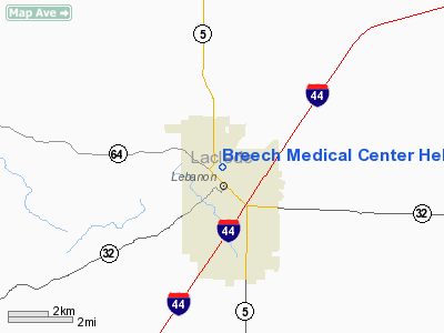
Breech Medical Center Heliport |
Location & QuickFacts
| FAA Information Effective: | 2008-09-25 |
| Airport Identifier: | MU93 |
| Airport Status: | Operational |
| Longitude/Latitude: | 092-39-46.6310W/37-41-13.1470N
-92.662953/37.686985 (Estimated) |
| Elevation: | 1230 ft / 374.90 m (Estimated) |
| Land: | 0 acres |
| From nearest city: | 0 nautical miles N of Lebanan, MO |
| Location: | Laclede County, MO |
| Magnetic Variation: | 03E (1990) |
Owner & Manager
| Ownership: | Privately owned |
| Owner: | Breech Medical Center |
| Address: | 325 Harwood Ave Box N
Lebanon, MO 65536 |
| Phone number: | 417-532-2136
EXT 249. |
| Manager: | Breech Medical Center |
| Address: | 325 Harwood Ave Box N
Lebanon, MO 65536 |
| Phone number: | 417-532-2136 |
Airport Operations and Facilities
| Airport Use: | Private
MEDICAL USE. |
| Wind indicator: | Yes |
| Segmented Circle: | No |
| Control Tower: | No |
| Lighting Schedule: | PHONE REQ
FOR PERIMETER LGTS CALL 417-532-2136 EXTN 249. |
| Sectional chart: | Kansas City |
| Region: | ACE - Central |
| Boundary ARTCC: | ZKC - Kansas City |
| Tie-in FSS: | COU - Columbia |
| FSS Toll Free: | 1-800-WX-BRIEF |
Runway Information
Helipad H1
| Dimension: | 32 x 32 ft / 9.8 x 9.8 m
CIRCULAR PAD. |
| Surface: | CONC, |
| |
Runway H1 |
Runway |
| Traffic Pattern: | Left | Left |
|
Radio Navigation Aids
| ID |
Type |
Name |
Ch |
Freq |
Var |
Dist |
| IEB | NDB | Lebanon | | 414.00 | 03E | 6.9 nm |
| AIZ | NDB | Kaiser | | 377.00 | 05E | 25.2 nm |
| BHN | NDB | Buckhorn | | 391.00 | 03E | 26.6 nm |
| AOV | NDB | Bilmart | | 341.00 | 02E | 43.1 nm |
| ILJ | NDB | Willard | | 254.00 | 03E | 43.8 nm |
| TBN | VOR | Forney | | 110.00 | 03E | 25.1 nm |
| SHY | VOR/DME | Sunshine | 021X | 108.40 | 05E | 21.4 nm |
| SGF | VORTAC | Springfield | 116X | 116.90 | 04E | 37.7 nm |
| DGD | VORTAC | Dogwood | 031X | 109.40 | 06E | 41.2 nm |
| MAP | VORTAC | Maples | 081X | 113.40 | 06E | 42.0 nm |
Remarks
- PRVDD APCH/DEP ARE MAINTAINED FOR A 20:1 GLIDE SLOPE AND CLEAR TRANSITIONAL SURFACES FOR A 2:1 SLOPE.
Images and information placed above are from
http://www.airport-data.com/airport/MU93/
We thank them for the data!
| General Info
|
| Country |
United States
|
| State |
MISSOURI
|
| FAA ID |
MU93
|
| Latitude |
37-41-13.147N
|
| Longitude |
092-39-46.631W
|
| Elevation |
1230 feet
|
| Near City |
LEBANAN
|
We don't guarantee the information is fresh and accurate. The data may
be wrong or outdated.
For more up-to-date information please refer to other sources.
|
|


