 |
|
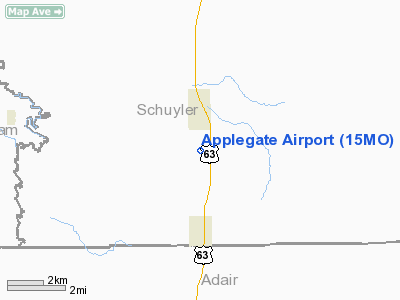
Location & QuickFacts
| FAA Information Effective: | 2008-09-25 |
| Airport Identifier: | 15MO |
| Airport Status: | Operational |
| Longitude/Latitude: | 092-33-55.6900W/40-23-31.1080N
-92.565469/40.391974 (Estimated) |
| Elevation: | 997 ft / 303.89 m (Surveyed) |
| Land: | 15 acres |
| From nearest city: | 1 nautical miles S of Queen City, MO |
| Location: | Schuyler County, MO |
| Magnetic Variation: | 03E (1985) |
Owner & Manager
| Ownership: | Publicly owned |
| Owner: | Paul Applegate |
| Address: | Route 1 Box 61a
Queen City, MO 63561 |
| Phone number: | 816-766-2644 |
| Manager: | Paul Applegate |
| Address: | Route 1 Box 61a
Queen City, MO 63561 |
| Phone number: | 816-766-2644
WORK PHONE (816) 626-2886. |
Airport Operations and Facilities
| Airport Use: | Private |
| Wind indicator: | Yes |
| Segmented Circle: | No |
| Control Tower: | No |
| Lighting Schedule: | DUSK-DAWN |
| Landing fee charge: | No |
| Sectional chart: | Chicago |
| Region: | ACE - Central |
| Boundary ARTCC: | ZKC - Kansas City |
| Tie-in FSS: | COU - Columbia |
| FSS on Airport: | No |
| FSS Toll Free: | 1-800-WX-BRIEF |
Airport Services
| Airframe Repair: | NONE |
| Power Plant Repair: | NONE |
Runway Information
Runway 16/34
| Dimension: | 2295 x 75 ft / 699.5 x 22.9 m |
| Surface: | TURF, Fair Condition |
| Edge Lights: | Non-standard lighting system
NSTD LIRL 2 RED THR LGTS BOTH ENDS; RY 16 THR 2 GREEN/RED LGTS 185 FT SOUTHEAST OF THR; RY 34 THR 2 GREEN/RED LGTS 195 FT NORTHWEST OF THR. |
| |
Runway 16 |
Runway 34 |
| Traffic Pattern: | Right | Left |
| Obstruction: | 20 ft trees, 300.0 ft from runway, 40 ft left of centerline, 15:1 slope to clear | 27 ft rr, 0.0 ft from runway, 85 ft right of centerline |
|
Radio Navigation Aids
| ID |
Type |
Name |
Ch |
Freq |
Var |
Dist |
| BEX | NDB | Bloomfield | | 269.00 | 02E | 22.1 nm |
| TVK | NDB | Centerville | | 290.00 | 04E | 23.4 nm |
| BZK | NDB | Brookfield | | 383.00 | 03E | 45.3 nm |
| FFL | NDB | Fairfield | | 332.00 | 03E | 45.6 nm |
| OTM | VOR/DME | Ottumwa | 053X | 111.60 | 06E | 39.8 nm |
| MCM | VOR/DME | Macon | 076X | 112.90 | 06E | 44.5 nm |
| IRK | VORTAC | Kirksville | 093X | 114.60 | 06E | 15.5 nm |
Remarks
- CONDL PROVIDED APCH TO EACH RWY IS MAINTAINED FOR A MIN 20-1 GLIDE SLOPE AND TRANSITIONAL SURFACE BE MAINTAINED FOR A 7-1 SLOPE.
Images and information placed above are from
http://www.airport-data.com/airport/15MO/
We thank them for the data!
| General Info
|
| Country |
United States
|
| State |
MISSOURI
|
| FAA ID |
15MO
|
| Latitude |
40-23-31.108N
|
| Longitude |
092-33-55.690W
|
| Elevation |
997 feet
|
| Near City |
QUEEN CITY
|
We don't guarantee the information is fresh and accurate. The data may
be wrong or outdated.
For more up-to-date information please refer to other sources.
|
|


