 |
|
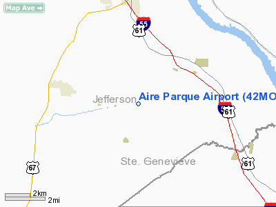
Location & QuickFacts
| FAA Information Effective: | 2008-09-25 |
| Airport Identifier: | 42MO |
| Airport Status: | Operational |
| Longitude/Latitude: | 090-23-20.4380W/38-07-23.1930N
-90.389011/38.123109 (Estimated) |
| Elevation: | 710 ft / 216.41 m (Estimated) |
| Land: | 89 acres |
| From nearest city: | 7 nautical miles S of Festus, MO |
| Location: | Jefferson County, MO |
| Magnetic Variation: | 02E (1985) |
Owner & Manager
| Ownership: | Privately owned |
| Owner: | Michael R. Blanke |
| Address: | 4203 E Four Ridge
Imperial, MO 63052 |
| Phone number: | 314-942-2441 |
| Manager: | Michael R. Blanke |
| Address: | 2400 E. Michael Rd
Festus, MO 63028 |
| Phone number: | 573-942-2441 |
Airport Operations and Facilities
| Airport Use: | Private |
| Wind indicator: | Yes |
| Segmented Circle: | No |
| Control Tower: | No |
| Sectional chart: | St Louis |
| Region: | ACE - Central |
| Boundary ARTCC: | ZKC - Kansas City |
| Tie-in FSS: | STL - Saint Louis |
| FSS Toll Free: | 1-800-WX-BRIEF |
Runway Information
Runway 02/20
| Dimension: | 2225 x 35 ft / 678.2 x 10.7 m |
| Surface: | TURF, Fair Condition |
| |
Runway 02 |
Runway 20 |
| Traffic Pattern: | Left | Left |
| Obstruction: | 50 ft trees, 20.0 ft from runway | 30 ft trees, 70.0 ft from runway, 2:1 slope to clear |
|
Radio Navigation Aids
| ID |
Type |
Name |
Ch |
Freq |
Var |
Dist |
| FES | NDB | Festus | | 269.00 | 01E | 4.4 nm |
| PRI | NDB | Perrine | | 367.00 | 02E | 21.6 nm |
| SAR | NDB | Sparta | | 239.00 | 01E | 32.5 nm |
| BL | NDB | Belleville | | 362.00 | 02E | 36.2 nm |
| UUV | NDB | Sullivan | | 356.00 | 02E | 37.2 nm |
| LM | NDB | Oblio | | 338.00 | 00E | 40.9 nm |
| CVM | NDB | Civic Memorial | | 263.00 | 02E | 48.8 nm |
| UBX | NDB | Cuba | | 380.00 | 01E | 49.2 nm |
| PJY | NDB | Pinckneyville | | 215.00 | 00E | 49.4 nm |
| SKE | TACAN | Scott | 059X | | 02E | 35.9 nm |
| CSX | VOR/DME | Cardinal | 111Y | 116.45 | 00E | 37.9 nm |
| FAM | VORTAC | Farmington | 104X | 115.70 | 01E | 28.0 nm |
| TOY | VORTAC | Troy | 107X | 116.00 | 04E | 43.1 nm |
| FTZ | VORTAC | Foristell | 045X | 110.80 | 05E | 44.0 nm |
| STL | VORTAC | St Louis | 121X | 117.40 | 01E | 44.6 nm |
| SUS | VOT | Spirit Of St Louis | | 112.20 | | 34.7 nm |
| STL | VOT | St Louis Lambert | | 111.00 | | 37.6 nm |
Remarks
- DEER ON & INVOF ARPT.
- +100 FT ELECTRICAL TRANSMISSION LINES 400-600 FT WEST OF RY.
- ULTRALIGHT ACTIVITY ON & INVOF ARPT.
- PRVDD CLEAR 20:1 APCH SFC SLOPE AND 7:1 TRANSITIONAL SFC SLOPE.
Images and information placed above are from
http://www.airport-data.com/airport/42MO/
We thank them for the data!
| General Info
|
| Country |
United States
|
| State |
MISSOURI
|
| FAA ID |
42MO
|
| Latitude |
38-07-23.193N
|
| Longitude |
090-23-20.438W
|
| Elevation |
710 feet
|
| Near City |
FESTUS
|
We don't guarantee the information is fresh and accurate. The data may
be wrong or outdated.
For more up-to-date information please refer to other sources.
|
|


