|
 |
|
||||
|
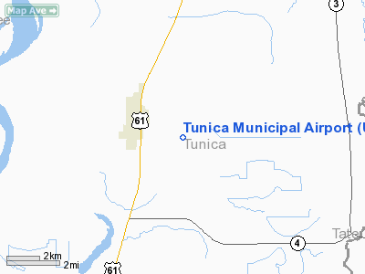
Tunica Municipal Airport (IATA: UTM, ICAO: KUTA, FAA LID: UTA, formerly M97) is a public-use airport located 1 nautical mile (2 km) east of the central business district of Tunica, a town in Tunica County, Mississippi, United States. It is owned by the Tunica Airport Commission. The airport is also known as Tunica Airport, not to be confused with the 10 acre privately-owned, public-use Tunica Airport (FAA LID: 30M) located 2 nautical miles (4 km) south of the center of town. Although most U.S. airports use the same three-letter location identifier for the FAA and IATA, Tunica Municipal Airport is assigned UTA by the FAA and UTM by the IATA (which assigned UTA to Mutare, Zimbabwe). HistoryDevelopment and improvement of the facility, located in the southern portion of the Memphis Metropolitan Area, has increased dramatically since the 1990s. Tunica Municipal is considered as one of the multiple beneficiaries of sales tax revenue generated by the addition of casinos to the county, following approval by the Mississippi Legislature to introduce gaming houses. The growth of the Tunica Resorts region into the third largest gaming destination behind Las Vegas, Nevada and Atlantic City, New Jersey, aided efforts to expand air service beyond charter flights. The airport opened in 2003 with a 5,500-foot runway. A $5.6 million project in 2004 extended the runway length to 7,000 feet, long enough to accommodate larger aircraft. In 2005, Tunica received its Part 130 certification to allow large jets from the Federal Aviation Administration. The first large jet, a 125-passenger Boeing 737 operated by Gold Transportation for Harrah's Entertainment, landed in Tunica in November, 2005. Prior to this flight, the largest flight that had landed in Tunica had 30 passengers. In May 2006, Boston-Maine Airways operating as Pan Am Clipper Connection, began Tunica's first scheduled service with three Boeing 727 flights per week from Hartsfield-Jackson Atlanta International Airport. That service ended in 2006 when the airline lost its routes from Atlanta. Casino charters continue to fly into Tunica growing passenger traffic despite the loss of the Clipper Connection service. In 2007, the airport had nearly 50,000 charter passengers. The charter traffic continued to grow with the announcement that Allegiant Airlines, would base under a contract with Harrah's Entertainment, to base two Allegiant aircraft at Tunica to ferry customers to Tunica, New Orleans, St. Louis and Council Bluffs, Iowa. In 2008, total passenger traffic to Tunica was more than 70,000 people. Tunica completed $40 million project to extend the runway to 8,500 feet, extend the taxiway and build a new hangar. The airport is working on a new terminal building which is expected to be completed in 2010. The passenger terminal will replace the temporary terminal building which has been in operating since the airport opened. AirTran Airways announced that it will begin nonstop flights from Tunica to Hartsfield-Jackson Atlanta International Airport effective May 6, 2010 with Boeing 717 aircraft. It will be the airport's first commercial service since 2006. Airlines and destinations
Facilities and aircraftTunica Municipal Airport covers an area of 71 acres (29 ha) and has one runway designated 17/35 with an asphalt surface measuring 8,500 x 150 ft (2,590 x 46 m). For the 12-month period ending June 30, 2007, the airport had 11,730 aircraft operations, an average of 32 per day: 84% general aviation, 16% scheduled commercial and <1% military. At that time there were 15 aircraft based at this airport: 87% single-engine and 13% multi-engine. The above content comes from Wikipedia and is published under free licenses – click here to read more.
Location & QuickFacts
Owner & Manager
Airport Operations and Facilities
Airport Communications
Airport Services
Runway InformationRunway 17/35
Radio Navigation Aids
Remarks
Images and information placed above are from We thank them for the data!
We don't guarantee the information is fresh and accurate. The data may
be wrong or outdated.
|
|||||||||||||||||||||||||||||||||||||||||||||||||||||||||||||||||||||||||||||||||||||||||||||||||||||||||||||||||||||||||||||||||||||||||||||||||||||||||||||||||||||||||||||||||||||||||||||||||||||||||||||||||||||||||||||||||||||||||||||||||||||||||||||||||||||||||||||||||||||||||||||||||||||||||||||||||||||||||||||||||||||||||||||||||||||||||||||||||||||

 |
|
Copyright 2004-2026 © by Airports-Worldwide.com, Vyshenskoho st. 36, Lviv 79010, Ukraine Legal Disclaimer |