 |
|
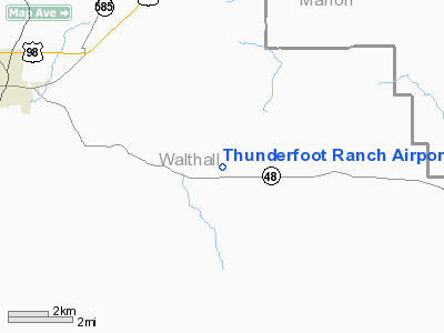
Thunderfoot Ranch Airport |
Location & QuickFacts
| FAA Information Effective: | 2008-09-25 |
| Airport Identifier: | 3MS2 |
| Airport Status: | Operational |
| Longitude/Latitude: | 090-01-42.3000W/31-04-44.6000N
-90.028417/31.079056 (Estimated) |
| Elevation: | 390 ft / 118.87 m (Estimated) |
| Land: | 100 acres |
| From nearest city: | 7 nautical miles E of Tylertown, MS |
| Location: | Walthall County, MS |
| Magnetic Variation: | 02E (1990) |
Owner & Manager
| Ownership: | Privately owned |
| Owner: | Tyler & Bonnie Harvey |
| Address: | Box 272
Tylertown, MS 39667 |
| Phone number: | 601-876-3174 |
| Manager: | Tyler & Bonnie Harvey |
| Address: | Box 272
Tylertown, MS 39667 |
| Phone number: | 601-876-3174 |
Airport Operations and Facilities
| Airport Use: | Private |
| Wind indicator: | Yes |
| Segmented Circle: | No |
| Control Tower: | No |
| Sectional chart: | New Orleans |
| Region: | ASO - Southern |
| Boundary ARTCC: | ZHU - Houston |
| Tie-in FSS: | GWO - Greenwood |
| FSS on Airport: | No |
| FSS Toll Free: | 1-800-WX-BRIEF |
Runway Information
Runway 18/36
| Dimension: | 3150 x 100 ft / 960.1 x 30.5 m |
| Surface: | TURF, Good Condition |
| |
Runway 18 |
Runway 36 |
| Traffic Pattern: | Left | Left |
| Displaced threshold: | 550.00 ft | 0.00 ft |
| Obstruction: | 50 ft trees, 550.0 ft from runway | 50 ft pline, 480.0 ft from runway |
|
Radio Navigation Aids
| ID |
Type |
Name |
Ch |
Freq |
Var |
Dist |
| BX | NDB | Carma | | 353.00 | 02E | 14.6 nm |
| FOH | NDB | Foxworth | | 331.00 | 05E | 16.9 nm |
| MC | NDB | Ferni | | 413.00 | 03E | 26.9 nm |
| BVV | NDB | Brookhaven | | 407.00 | 03E | 37.4 nm |
| MJD | NDB | Picayune | | 276.00 | 01E | 40.1 nm |
| FNA | NDB | Florenville | | 371.00 | 03E | 41.3 nm |
| HS | NDB | Hanco | | 221.00 | 01E | 48.0 nm |
| AYI | NDB | Hanco | | 221.00 | 03E | 48.0 nm |
| DEF | NDB | Slidell | | 256.00 | 03E | 48.1 nm |
| HMU | VOR | Hammond | | 109.60 | 03E | 39.2 nm |
| PCU | VOR/DME | Picayune | 059X | 112.20 | 05E | 34.7 nm |
| MCB | VORTAC | Mc Comb | 114X | 116.70 | 03E | 18.0 nm |
| LBY | VORTAC | Eaton | 043X | 110.60 | 05E | 41.0 nm |
Remarks
Images and information placed above are from
http://www.airport-data.com/airport/3MS2/
We thank them for the data!
| General Info
|
| Country |
United States
|
| State |
MISSISSIPPI
|
| FAA ID |
3MS2
|
| Latitude |
31-04-44.600N
|
| Longitude |
090-01-42.300W
|
| Elevation |
390 feet
|
| Near City |
TYLERTOWN
|
We don't guarantee the information is fresh and accurate. The data may
be wrong or outdated.
For more up-to-date information please refer to other sources.
|
|


