 |
|
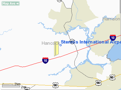
Stennis International Airport |
| Stennis International Airport |
| IATA: none – ICAO: KHSA – FAA LID: HSA |
| Summary |
| Airport type |
Public |
| Owner/Operator |
Hancock County Port and Harbor Commission |
| Serves |
Bay St. Louis, Mississippi |
| Elevation AMSL |
23 ft / 7 m |
| Coordinates |
30°22′04″N 089°27′17″W / 30.36778°N 89.45472°W / 30.36778; -89.45472 |
| Runways |
| Direction |
Length |
Surface |
| ft |
m |
| 18/36 |
8,497 |
2,590 |
Asphalt |
| Statistics (2006) |
| Aircraft operations |
63,600 |
| Based aircraft |
104 |
| Source: FAA and airport web site |
Stennis International Airport (ICAO: KHSA, FAA LID: HSA) is a public airport located eight miles (13 km) northwest of the central business district of Bay St. Louis, a city in Hancock County, Mississippi, United States. It is owned and operated by the Hancock County Port and Harbor Commission.
Although most U.S. airports use the same three-letter location identifier for the FAA and IATA, this airport is assigned HSA by the FAA but has no designation from the IATA.
Facilities and aircraft
Stennis International Airport covers an area of 591 acres (239 ha) at an altitude of 23 feet (7 m) above mean sea level. It has one runway designated 18/36 with a 8,497 x 150 ft (2,590 x 46 m) asphalt surface. For the 12-month period ending December 31, 2006, the airport had 63,600 aircraft operations, an average of 174 per day: 90% general aviation and 10% military. At that time there were 104 aircraft based at this airport: 68% single-engine 27% multi-engine, 3% jet and 2% ultralight.
The above content comes from Wikipedia and is published under free licenses – click here to read more.
Location & QuickFacts
| FAA Information Effective: | 2008-09-25 |
| Airport Identifier: | HSA |
| Airport Status: | Operational |
| Longitude/Latitude: | 089-27-16.6000W/30-22-04.1000N
-89.454611/30.367806 (Estimated) |
| Elevation: | 23 ft / 7.01 m (Surveyed) |
| Land: | 591 acres |
| From nearest city: | 8 nautical miles NW of Bay St Louis, MS |
| Location: | Hancock County, MS |
| Magnetic Variation: | 01E (2000) |
Owner & Manager
| Ownership: | Publicly owned |
| Owner: | Hancock Co. Port And Harbor Comm.
HANCOCK COUNTY PORT & HARBOR COMMISSION. |
| Address: | Po Box 2267
Bay St Louis, MS 39521 |
| Phone number: | 228-467-7070 |
| Manager: | Bill Cotter |
| Address: | Box 2267
Bay St Louis, MS 39521 |
| Phone number: | 228-467-7070 |
Airport Operations and Facilities
| Airport Use: | Open to public |
| Wind indicator: | Yes |
| Segmented Circle: | Yes |
| Control Tower: | Yes |
| Lighting Schedule: | DUSK-DAWN
HIRL RY 18/36 PRESET MED INTST SS-SR; TO INCR INTST & ACTVT REIL RY 18/36 - CTAF. |
| Beacon Color: | Clear-Green (lighted land airport) |
| Landing fee charge: | No |
| Sectional chart: | New Orleans |
| Region: | ASO - Southern |
| Boundary ARTCC: | ZHU - Houston |
| Tie-in FSS: | GWO - Greenwood |
| FSS on Airport: | No |
| FSS Toll Free: | 1-800-WX-BRIEF |
| NOTAMs Facility: | HSA (NOTAM-d service avaliable) |
| Certification type/date: | IV A U 12/199
CLSD TO ACR OPNS WITH MORE THAN 30 PSGR SEAT EXCEPT 48 HR PPR CALL AMGR 228-467-7070. |
| Federal Agreements: | NGSY |
Airport Communications
| CTAF: | 123.000 |
| Unicom: | 123.000 |
Airport Services
| Fuel available: | 100LLA
FOR FUEL AFTER HRS CALL 228-463-0404 OR 228-467-7070. |
| Airframe Repair: | MAJOR |
| Power Plant Repair: | MAJOR |
Runway Information
Runway 18/36
| Dimension: | 8497 x 150 ft / 2589.9 x 45.7 m |
| Surface: | ASPH, Good Condition |
| Surface Treatment: | Saw-cut or plastic Grooved |
| Weight Limit: | Single wheel: 120000 lbs.
Dual wheel: 170000 lbs.
Dual tandem wheel: 270000 lbs. |
| Edge Lights: | High |
| |
Runway 18 |
Runway 36 |
| Longitude: | 089-27-16.4742W | 089-27-16.7439W |
| Latitude: | 30-22-46.1499N | 30-21-22.0445N |
| Elevation: | 23.00 ft | 13.00 ft |
| Alignment: | 127 | 0 |
| ILS Type: | ILS
| |
| Traffic Pattern: | Left | Left |
| Markings: | Precision instrument, Good Condition | Non-precision instrument, Good Condition |
| Crossing Height: | 53.00 ft | 55.00 ft |
| VASI: | 4-light PAPI on left side | 4-light PAPI on left side |
| Visual Glide Angle: | 3.00° | 3.00° |
| Approach lights: | MALSR
OTS INDEFLY. | |
| Runway End Identifier: | Yes | Yes |
| Obstruction: | 40 ft tree, 2100.0 ft from runway, 200 ft left of centerline, 47:1 slope to clear | 55 ft trees, 2100.0 ft from runway, 34:1 slope to clear |
|
Radio Navigation Aids
| ID |
Type |
Name |
Ch |
Freq |
Var |
Dist |
| AYI | NDB | Hanco | | 221.00 | 03E | 5.0 nm |
| HS | NDB | Hanco | | 221.00 | 01E | 5.0 nm |
| MJD | NDB | Picayune | | 276.00 | 01E | 12.8 nm |
| FNA | NDB | Florenville | | 371.00 | 03E | 19.2 nm |
| DEF | NDB | Slidell | | 256.00 | 03E | 20.1 nm |
| BX | NDB | Carma | | 353.00 | 02E | 37.4 nm |
| BIX | TACAN | Keesler | 055X | | 01E | 27.3 nm |
| PCU | VOR/DME | Picayune | 059X | 112.20 | 05E | 18.4 nm |
| GPT | VOR/DME | Gulfport | 27X | 109.00 | 02E | 19.8 nm |
| HRV | VORTAC | Harvey | 088X | 114.10 | 02E | 42.2 nm |
| NEW | VOT | New Orleans Lakefront | | 111.00 | | 35.7 nm |
Remarks
- FOR MAJOR & MINOR REPAIRS AFTER HRS CALL 228-255-3755 OR 228-255-4455.
- NUMEROUS LOW FLYING FISH SPOTTER ACFT OPERATING NEAR SHORELINE BTW GULFPORT & BAY ST. LOUIS SR-SS.
- NUMEROUS FLOCKS OF BIRDS AER 36.
Images and information placed above are from
http://www.airport-data.com/airport/HSA/
We thank them for the data!
| General Info
|
| Country |
United States
|
| State |
MISSISSIPPI
|
| FAA ID |
HSA
|
| Latitude |
30-22-04.108N
|
| Longitude |
089-27-16.599W
|
| Elevation |
23 feet
|
| Near City |
BAY ST LOUIS
|
We don't guarantee the information is fresh and accurate. The data may
be wrong or outdated.
For more up-to-date information please refer to other sources.
|
|


