 |
|
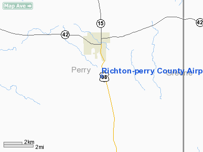
Richton - Perry County Airport |
Location & QuickFacts
| FAA Information Effective: | 2008-09-25 |
| Airport Identifier: | M59 |
| Airport Status: | Operational |
| Longitude/Latitude: | 088-56-06.1720W/31-19-02.6380N
-88.935048/31.317399 (Estimated) |
| Elevation: | 167 ft / 50.90 m (Estimated) |
| Land: | 55 acres |
| From nearest city: | 2 nautical miles S of Richton, MS |
| Location: | Perry County, MS |
| Magnetic Variation: | 02E (1985) |
Owner & Manager
| Ownership: | Publicly owned |
| Owner: | City Of Richton
CITY OF RICHTON AND PERRY COUNTY. |
| Address: | Po Box 493
Richton, MS 39476 |
| Phone number: | 601-788-6015 |
| Manager: | Joe Blackman
CHAIRMAN AIRPORT BOARD. |
| Address: | P.o. Box 1500
Richton, MS 39476 |
| Phone number: | 601-788-6210 |
Airport Operations and Facilities
| Airport Use: | Open to public |
| Wind indicator: | Yes |
| Segmented Circle: | Yes |
| Control Tower: | No |
| Lighting Schedule: | DUSK-DAWN
ACTVT MIRL & PAPI RYS 18 & 36 - CTAF |
| Beacon Color: | Clear-Green (lighted land airport) |
| Landing fee charge: | No |
| Sectional chart: | New Orleans |
| Region: | ASO - Southern |
| Boundary ARTCC: | ZHU - Houston |
| Tie-in FSS: | GWO - Greenwood |
| FSS on Airport: | No |
| FSS Toll Free: | 1-800-WX-BRIEF |
| NOTAMs Facility: | GWO (NOTAM-d service avaliable) |
| Federal Agreements: | NY1 |
Airport Communications
Airport Services
| Airframe Repair: | NONE |
| Power Plant Repair: | NONE |
| Bottled Oxygen: | NONE |
| Bulk Oxygen: | NONE |
Runway Information
Runway 18/36
| Dimension: | 3000 x 60 ft / 914.4 x 18.3 m |
| Surface: | ASPH, Good Condition |
| Weight Limit: | Single wheel: 20000 lbs. |
| Edge Lights: | Medium
MIRL OTS INDEFLY. |
| |
Runway 18 |
Runway 36 |
| Traffic Pattern: | Left | Left |
| Markings: | Basic, Good Condition | Basic, Good Condition |
| VASI: | 2-light PAPI on left side
PAPI OTS INDEFLY. | 2-light PAPI on left side
PAPI OTS INDEFLY. |
| Obstruction: | 79 ft trees, 530.0 ft from runway, 150 ft right of centerline, 4:1 slope to clear | 25 ft brush, 470.0 ft from runway, 10:1 slope to clear |
|
Radio Navigation Aids
| ID |
Type |
Name |
Ch |
Freq |
Var |
Dist |
| THJ | NDB | Tallahala | | 346.00 | 00E | 25.8 nm |
| FOH | NDB | Foxworth | | 331.00 | 05E | 45.4 nm |
| MO | NDB | Wisle | | 248.00 | 02E | 46.7 nm |
| LBY | VORTAC | Eaton | 043X | 110.60 | 05E | 21.5 nm |
| GCV | VORTAC | Greene County | 104X | 115.70 | 05E | 26.6 nm |
| SJI | VORTAC | Semmes | 100X | 115.30 | 05E | 46.3 nm |
Remarks
Images and information placed above are from
http://www.airport-data.com/airport/M59/
We thank them for the data!
| General Info
|
| Country |
United States
|
| State |
MISSISSIPPI
|
| FAA ID |
M59
|
| Latitude |
31-19-02.638N
|
| Longitude |
088-56-06.172W
|
| Elevation |
167 feet
|
| Near City |
RICHTON
|
We don't guarantee the information is fresh and accurate. The data may
be wrong or outdated.
For more up-to-date information please refer to other sources.
|
|


