 |
|
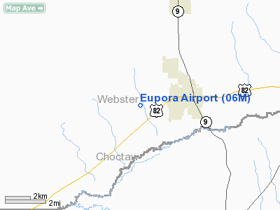
Location & QuickFacts
| FAA Information Effective: | 2008-09-25 |
| Airport Identifier: | 06M |
| Airport Status: | Operational |
| Longitude/Latitude: | 089-18-45.2490W/33-32-04.4370N
-89.312569/33.534566 (Estimated) |
| Elevation: | 450 ft / 137.16 m (Estimated) |
| Land: | 116 acres |
| From nearest city: | 2 nautical miles W of Eupora, MS |
| Location: | Webster County, MS |
| Magnetic Variation: | 02E (1985) |
Owner & Manager
| Ownership: | Publicly owned |
| Owner: | Town Of Eupora |
| Address: | 102 E Clark Ave
Eupora, MS 39744 |
| Phone number: | 662-258-2291 |
| Manager: | Tommy Lott, Mayor |
| Address: | Town Of Europa, 102 E Clark Ave
Eupora, MS 39744 |
| Phone number: | 662-258-2291 |
Airport Operations and Facilities
| Airport Use: | Open to public |
| Wind indicator: | Yes |
| Segmented Circle: | Yes |
| Control Tower: | No |
| Lighting Schedule: | DUSK-DAWN
ACTIVATE MIRL RY 14/32 AND PAPI RY 14/32 - CTAF. |
| Beacon Color: | Clear-Green (lighted land airport) |
| Landing fee charge: | No |
| Sectional chart: | Memphis |
| Region: | ASO - Southern |
| Boundary ARTCC: | ZME - Memphis |
| Tie-in FSS: | GWO - Greenwood |
| FSS on Airport: | No |
| FSS Toll Free: | 1-800-WX-BRIEF |
| NOTAMs Facility: | GWO (NOTAM-d service avaliable) |
| Federal Agreements: | NY1 |
Airport Communications
Airport Services
| Airframe Repair: | NONE |
| Power Plant Repair: | NONE |
| Bottled Oxygen: | NONE |
| Bulk Oxygen: | NONE |
Runway Information
Runway 14/32
| Dimension: | 3000 x 60 ft / 914.4 x 18.3 m |
| Surface: | ASPH, Good Condition |
| Weight Limit: | Single wheel: 20000 lbs. |
| Edge Lights: | Medium |
| |
Runway 14 |
Runway 32 |
| Traffic Pattern: | Left | Left |
| Markings: | Basic, Good Condition | Basic, Good Condition |
| Crossing Height: | 35.00 ft | 42.00 ft |
| VASI: | 2-light PAPI on left side | 2-light PAPI on left side |
| Visual Glide Angle: | 3.00° | 3.00° |
| Obstruction: | 80 ft trees, 760.0 ft from runway, 150 ft left of centerline, 7:1 slope to clear | 38 ft tree, 1100.0 ft from runway, 140 ft left of centerline, 23:1 slope to clear |
|
Radio Navigation Aids
| ID |
Type |
Name |
Ch |
Freq |
Var |
Dist |
| STF | NDB | Bryan | | 281.00 | 02E | 24.0 nm |
| LMS | NDB | Louisville | | 212.00 | 00E | 26.7 nm |
| OSX | NDB | Kosciusko | | 269.00 | 00W | 29.0 nm |
| SBQ | NDB | Scobey | | 245.00 | 01E | 35.3 nm |
| MPE | NDB | Philadelphia | | 219.00 | 01E | 45.2 nm |
| OTB | VOR/DME | Tupelo | 035X | 109.80 | 04E | 48.8 nm |
| IGB | VORTAC | Bigbee | 109X | 116.20 | 04E | 40.2 nm |
| CBM | VORTAC | Caledonia | 099X | 115.20 | 00E | 44.2 nm |
| SQS | VORTAC | Sidon | 094X | 114.70 | 03E | 48.5 nm |
Images and information placed above are from
http://www.airport-data.com/airport/06M/
We thank them for the data!
| General Info
|
| Country |
United States
|
| State |
MISSISSIPPI
|
| FAA ID |
06M
|
| Latitude |
33-32-04.437N
|
| Longitude |
089-18-45.249W
|
| Elevation |
450 feet
|
| Near City |
EUPORA
|
We don't guarantee the information is fresh and accurate. The data may
be wrong or outdated.
For more up-to-date information please refer to other sources.
|
|


