 |
|
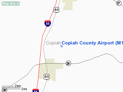
Location & QuickFacts
| FAA Information Effective: | 2008-09-25 |
| Airport Identifier: | M11 |
| Airport Status: | Operational |
| Longitude/Latitude: | 090-22-07.3280W/31-54-10.5710N
-90.368702/31.902936 (Estimated) |
| Elevation: | 443 ft / 135.03 m (Estimated) |
| Land: | 70 acres |
| From nearest city: | 4 nautical miles S of Crystal Springs, MS |
| Location: | Copiah County, MS |
| Magnetic Variation: | 03E (1985) |
Owner & Manager
| Ownership: | Publicly owned |
| Owner: | Copiah County
MR. RONNIE BARLOW-COUNTY ADMINISTRATOR |
| Address: | Po Box 551
Hazelhurst, MS 39083 |
| Phone number: | 601-894-1858 |
| Manager: | Steve See |
| Address: | 1001 Airport Ln.
Hazelhurst, MS 39083 |
| Phone number: | 601-892-0794 |
Airport Operations and Facilities
| Airport Use: | Open to public |
| Wind indicator: | Yes |
| Segmented Circle: | No |
| Control Tower: | No |
| Lighting Schedule: | DUSK-DAWN |
| Beacon Color: | Clear-Green (lighted land airport) |
| Landing fee charge: | No |
| Sectional chart: | New Orleans |
| Region: | ASO - Southern |
| Boundary ARTCC: | ZME - Memphis |
| Tie-in FSS: | GWO - Greenwood |
| FSS on Airport: | No |
| FSS Toll Free: | 1-800-WX-BRIEF |
| NOTAMs Facility: | GWO (NOTAM-d service avaliable) |
| Federal Agreements: | NGY |
Airport Communications
Airport Services
| Fuel available: | 100LL |
| Airframe Repair: | MAJOR |
| Power Plant Repair: | MAJOR |
| Bottled Oxygen: | NONE |
| Bulk Oxygen: | NONE |
Runway Information
Runway 17/35
| Dimension: | 3000 x 75 ft / 914.4 x 22.9 m |
| Surface: | ASPH, Fair Condition |
| Weight Limit: | Single wheel: 10000 lbs. |
| Edge Lights: | Medium |
| |
Runway 17 |
Runway 35 |
| Traffic Pattern: | Left | Left |
| Markings: | Basic, Fair Condition | Basic, Fair Condition |
| Crossing Height: | 0.00 ft | 30.00 ft |
| VASI: | | 2-light PAPI on left side |
| Visual Glide Angle: | 0.00° | 3.00° |
| Runway End Identifier: | Yes | Yes |
| Obstruction: | 66 ft trees, 1540.0 ft from runway, 100 ft left of centerline, 20:1 slope to clear | 30 ft trees, 1240.0 ft from runway, 75 ft left of centerline, 34:1 slope to clear |
|
Radio Navigation Aids
| ID |
Type |
Name |
Ch |
Freq |
Var |
Dist |
| BVV | NDB | Brookhaven | | 407.00 | 03E | 17.9 nm |
| RYB | NDB | Raymond | | 375.00 | 03E | 24.1 nm |
| JH | NDB | Brenz | | 260.00 | 02E | 31.1 nm |
| VKS | NDB | Vicksburg | | 382.00 | 03E | 34.7 nm |
| TV | NDB | Savry | | 344.00 | 02E | 39.3 nm |
| MC | NDB | Ferni | | 413.00 | 03E | 39.6 nm |
| FOH | NDB | Foxworth | | 331.00 | 05E | 46.1 nm |
| HAH | NDB | Natchez-adams County | | 388.00 | 03E | 48.9 nm |
| MCB | VORTAC | Mc Comb | 114X | 116.70 | 03E | 36.4 nm |
| JAN | VORTAC | Jackson | 073X | 112.60 | 05E | 37.8 nm |
| JAN | VOT | Jackson | | 111.00 | | 29.0 nm |
Remarks
- TERRAIN DROPS OFF ABRUPTLY 100' FROM BOTH ENDS OF RWY 17/35.
- LIVESTOCK ON & INVOF RWY.
Images and information placed above are from
http://www.airport-data.com/airport/M11/
We thank them for the data!
| General Info
|
| Country |
United States
|
| State |
MISSISSIPPI
|
| FAA ID |
M11
|
| Latitude |
31-54-10.571N
|
| Longitude |
090-22-07.328W
|
| Elevation |
443 feet
|
| Near City |
CRYSTAL SPRINGS
|
We don't guarantee the information is fresh and accurate. The data may
be wrong or outdated.
For more up-to-date information please refer to other sources.
|
|


