 |
|
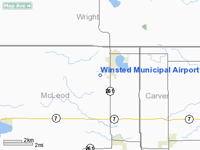
Winsted Municipal Airport |
Location & QuickFacts
| FAA Information Effective: | 2008-09-25 |
| Airport Identifier: | 10D |
| Airport Status: | Operational |
| Longitude/Latitude: | 094-04-00.9030W/44-56-59.8660N
-94.066918/44.949963 (Estimated) |
| Elevation: | 1030 ft / 313.94 m (Estimated) |
| Land: | 43 acres |
| From nearest city: | 1 nautical miles SW of Winsted, MN |
| Location: | Mc Leod County, MN |
| Magnetic Variation: | 04E (1985) |
Owner & Manager
| Ownership: | Publicly owned |
| Owner: | City Of Winsted |
| Address: | Po Box 126
Winsted, MN 55395 |
| Phone number: | 612-485-2366 |
| Manager: | Russ Paschke |
| Address: | Po Box 447
Winsted, MN 55395 |
| Phone number: | 612-485-3720 |
Airport Operations and Facilities
| Airport Use: | Open to public |
| Wind indicator: | Yes |
| Segmented Circle: | No |
| Control Tower: | No |
| Lighting Schedule: | DUSK-DAWN |
| Beacon Color: | Clear-Green (lighted land airport) |
| Landing fee charge: | No |
| Sectional chart: | Twin Cities |
| Region: | AGL - Great Lakes |
| Boundary ARTCC: | ZMP - Minneapolis |
| Tie-in FSS: | PNM - Princeton |
| FSS on Airport: | No |
| FSS Toll Free: | 1-800-WX-BRIEF |
| NOTAMs Facility: | PNM (NOTAM-d service avaliable) |
| Federal Agreements: | NY1 |
Airport Communications
Airport Services
| Fuel available: | 100LL |
| Airframe Repair: | NONE |
| Power Plant Repair: | NONE |
| Bottled Oxygen: | NONE |
| Bulk Oxygen: | NONE |
Runway Information
Runway 09/27
| Dimension: | 3248 x 200 ft / 990.0 x 61.0 m |
| Surface: | TURF, Good Condition |
| Edge Lights: | Low |
| |
Runway 09 |
Runway 27 |
| Longitude: | 094-04-17.9900W | 094-03-32.8200W |
| Latitude: | 44-57-13.8600N | 44-57-13.8600N |
| Elevation: | 1030.00 ft | 1030.00 ft |
| Traffic Pattern: | Left | Left |
| Markings: | None,
RY 09/27 MARKED WITH YELLOW CONES. | None, |
| Obstruction: | 17 ft road, 529.0 ft from runway, 31:1 slope to clear | 32 ft trees, 450.0 ft from runway, 150 ft left of centerline, 14:1 slope to clear |
|
Radio Navigation Aids
| ID |
Type |
Name |
Ch |
Freq |
Var |
Dist |
| GYL | NDB | Glencoe | | 407.00 | 03E | 11.4 nm |
| HCD | NDB | Hutchinson | | 209.00 | 04E | 14.6 nm |
| PNM | NDB | Princeton | | 368.00 | 03E | 41.7 nm |
| MS | NDB | Narco | | 266.00 | 02E | 42.2 nm |
| PPI | NDB | Hopey | | 400.00 | 03E | 48.1 nm |
| CBG | NDB | Cambridge | | 350.00 | 03E | 49.9 nm |
| ULM | NDB/DME | New Ulm | 050X | 272.00 | 04E | 42.2 nm |
| FCM | VOR/DME | Flying Cloud | 055X | 111.80 | 06E | 27.0 nm |
| MSP | VOR/DME | Minneapolis | 100X | 115.30 | 02E | 35.5 nm |
| STC | VOR/DME | St Cloud | 058X | 112.10 | 03E | 36.0 nm |
| MKT | VOR/DME | Mankato | 045X | 110.80 | 07E | 44.4 nm |
| ILL | VOR/DME | Willmar | 084X | 113.70 | 04E | 44.6 nm |
| BDH | VOR/DME | Willmar | 84X | 113.70 | 04E | 46.1 nm |
| DWN | VORTAC | Darwin | 027X | 109.00 | 07E | 18.4 nm |
| GEP | VORTAC | Gopher | 120X | 117.30 | 06E | 31.7 nm |
| FGT | VORTAC | Farmington | 104X | 115.70 | 06E | 42.3 nm |
| MSP | VOT | Minneapolis St Paul | | 111.00 | | 36.5 nm |
| STP | VOT | St Paul | | 114.40 | | 42.9 nm |
Remarks
- BE ALERT OF ULTRALIGHT TRAFFIC IN LOWER PATTERN.
Images and information placed above are from
http://www.airport-data.com/airport/10D/
We thank them for the data!
| General Info
|
| Country |
United States
|
| State |
MINNESOTA
|
| FAA ID |
10D
|
| Latitude |
44-56-59.866N
|
| Longitude |
094-04-00.903W
|
| Elevation |
1030 feet
|
| Near City |
WINSTED
|
We don't guarantee the information is fresh and accurate. The data may
be wrong or outdated.
For more up-to-date information please refer to other sources.
|
|


