|
|
Winona Muni - Max Conrad Fld Airport |
Winona Municipal Airport
Max Conrad Field |
| IATA: ONA – ICAO: KONA |
| Summary |
| Airport type |
Public |
| Operator |
City of Winona |
| Location |
Winona, Minnesota |
| Elevation AMSL |
656 ft / 199.9 m |
| Coordinates |
44°04′38″N 91°42′30″W / 44.07722°N 91.70833°W / 44.07722; -91.70833Coordinates: 44°04′38″N 91°42′30″W / 44.07722°N 91.70833°W / 44.07722; -91.70833 |
| Runways |
| Direction |
Length |
Surface |
| ft |
m |
| 12/30 |
5,199 |
1,585 |
Asphalt |
| 17/35 |
2,553 |
778 |
Asphalt |
Winona Municipal Airport (IATA: ONA, ICAO: KONA), also known as Max Conrad Field, is a public airport located three miles (five km) northwest of the central business district (CBD) of Winona, Minnesota and adjacent to Goodview along the Mississippi River, in Winona County, Minnesota, USA. It serves general aviation for Winona and the surrounding area. The airport covers 575 acres (233 ha) and has two runways. There is no scheduled air service.
Cargo
- Bemidji Airlines (Minneapolis/St. Paul)
The above content comes from Wikipedia and is published under free licenses – click here to read more.
|
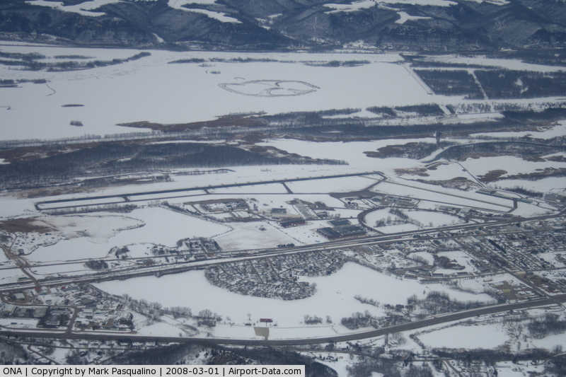
 |
(Click on the photo to enlarge) |
|
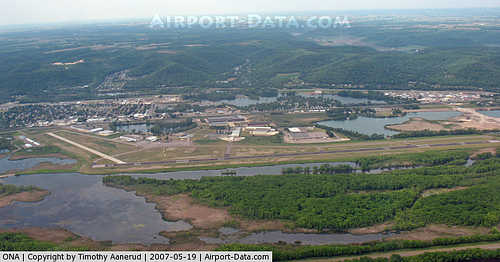 |
(Click on the photo to enlarge) |
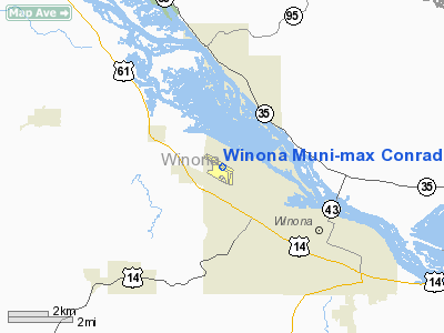
Location & QuickFacts
| FAA Information Effective: | 2008-09-25 |
| Airport Identifier: | ONA |
| Airport Status: | Operational |
| Longitude/Latitude: | 091-42-29.9410W/44-04-37.9670N
-91.708317/44.077213 (Estimated) |
| Elevation: | 656 ft / 199.95 m (Surveyed) |
| Land: | 575 acres |
| From nearest city: | 3 nautical miles NW of Winona, MN |
| Location: | Winona County, MN |
| Magnetic Variation: | 01E (1995) |
Owner & Manager
| Ownership: | Publicly owned |
| Owner: | City Of Winona |
| Address: | Box 378
Winona, MN 55987 |
| Phone number: | 507-452-8550 |
| Manager: | Keith Nelson |
| Address: | Box 378
Winona, MN 55987 |
| Phone number: | 507-457-8274 |
Airport Operations and Facilities
| Airport Use: | Open to public |
| Wind indicator: | Yes |
| Segmented Circle: | Yes |
| Control Tower: | No |
| Lighting Schedule: | DUSK-DAWN
MIRL RY 12/30 PRESET ON LOW INTST, TO INCR INTST & ACTVT VASI RYS 12 & 30, REIL RY 12 & MALSR RY 30 - CTAF. |
| Beacon Color: | Clear-Green (lighted land airport) |
| Landing fee charge: | No |
| Sectional chart: | Green Bay |
| Region: | AGL - Great Lakes |
| Boundary ARTCC: | ZMP - Minneapolis |
| Tie-in FSS: | PNM - Princeton |
| FSS on Airport: | No |
| FSS Toll Free: | 1-800-WX-BRIEF |
| NOTAMs Facility: | ONA (NOTAM-d service avaliable) |
| Federal Agreements: | NGY |
Airport Communications
| CTAF: | 122.800 |
| Unicom: | 122.800 |
Airport Services
| Fuel available: | 100LLA |
| Airframe Repair: | MAJOR |
| Power Plant Repair: | MAJOR |
| Bottled Oxygen: | NONE |
Runway Information
Runway 12/30
| Dimension: | 5199 x 98 ft / 1584.7 x 29.9 m |
| Surface: | ASPH, Good Condition
GRASS GROWING THROUGH CRACKS, PAVEMENT BLEACHED. |
| Weight Limit: | Single wheel: 30000 lbs.
Dual wheel: 55000 lbs. |
| Edge Lights: | Medium |
| |
Runway 12 |
Runway 30 |
| Longitude: | 091-43-10.0162W | 091-42-07.9889W |
| Latitude: | 44-04-58.0246N | 44-04-32.8424N |
| Elevation: | 655.00 ft | 655.00 ft |
| Alignment: | 119 | 127 |
| Traffic Pattern: | Left | Right |
| Markings: | Precision instrument, Good Condition | Precision instrument, Good Condition |
| Crossing Height: | 42.00 ft | 42.00 ft |
| VASI: | 4-box on left side | 4-box on left side |
| Visual Glide Angle: | 3.00° | 3.00° |
| Approach lights: | | MALSR |
| Runway End Identifier: | Yes | No |
| Obstruction: | 10 ft trees, 210.0 ft from runway, 420 ft left of centerline, 1:1 slope to clear
RWY 12 15 FT TREES 0-150 FT FM RY END 210 FT L. | 33 ft trees, 1300.0 ft from runway, 375 ft right of centerline, 33:1 slope to clear
RWY 30: TREES +10, 100-200 ' FM END, 100-500'L. |
|
Runway 17/35
| Dimension: | 2553 x 74 ft / 778.2 x 22.6 m |
| Surface: | ASPH, Fair Condition
GRASS GROWING THROUGH CRACKS, PAVEMENT BLEACHED. |
| |
Runway 17 |
Runway 35 |
| Longitude: | 091-42-13.0246W | 091-42-10.3663W |
| Latitude: | 44-04-35.2106N | 44-04-10.0843N |
| Elevation: | 655.00 ft | 655.00 ft |
| Alignment: | 127 | 127 |
| Traffic Pattern: | Left | Right |
| Markings: | Basic, Fair Condition | Basic, Fair Condition |
| Displaced threshold: | 0.00 ft | 151.00 ft |
| Runway End Identifier: | No | No |
| Obstruction: | 67 ft trees, 1550.0 ft from runway, 230 ft right of centerline, 20:1 slope to clear | 63 ft trees, 1100.0 ft from runway, 37 ft left of centerline, 14:1 slope to clear
RWY 35 APCH SLOPE 19:1 TO DSPLCD THLD.
3 FT FENCE AT 169 FT, |
|
Radio Navigation Aids
| ID |
Type |
Name |
Ch |
Freq |
Var |
Dist |
| CHU | NDB | Caledonia | | 209.00 | 03E | 30.9 nm |
| BCK | NDB | Black River Falls | | 362.00 | 00E | 38.6 nm |
| CJJ | NDB | Cresco | | 293.00 | 02E | 46.5 nm |
| CMY | NDB | Mccoy | | 412.00 | 00E | 46.9 nm |
| DEH | NDB | Decorah | | 236.00 | 01E | 48.2 nm |
| ONA | VOR/DME | Winona | 051X | 111.40 | 01E | 0.1 nm |
| LSE | VOR/DME | La Crosse | 021X | 108.40 | 02E | 23.0 nm |
| RST | VOR/DME | Rochester | 057X | 112.00 | 05E | 42.3 nm |
| ODI | VORTAC | Nodine | 126X | 117.90 | 01E | 14.4 nm |
| UKN | VORTAC | Waukon | 113X | 116.60 | 05E | 48.5 nm |
Remarks
- DEER AND WATERFOWL ON AND INVOF ARPT.
Images and information placed above are from
http://www.airport-data.com/airport/ONA/
We thank them for the data!
| General Info
|
| Country |
United States
|
| State |
MINNESOTA
|
| FAA ID |
ONA
|
| Latitude |
44-04-37.967N
|
| Longitude |
091-42-29.941W
|
| Elevation |
656 feet
|
| Near City |
WINONA
|
We don't guarantee the information is fresh and accurate. The data may
be wrong or outdated.
For more up-to-date information please refer to other sources.
|
|