 |
|
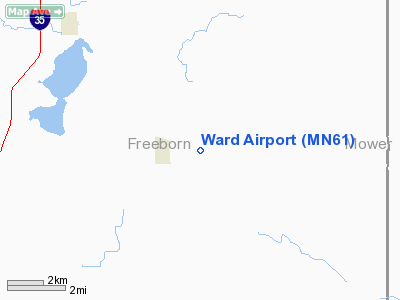
Location & QuickFacts
| FAA Information Effective: | 2008-09-25 |
| Airport Identifier: | MN61 |
| Airport Status: | Operational |
| Longitude/Latitude: | 093-10-40.7290W/43-45-36.8560N
-93.177980/43.760238 (Estimated) |
| Elevation: | 1205 ft / 367.28 m (Estimated) |
| Land: | 0 acres |
| From nearest city: | 2 nautical miles SE of Hollandale, MN |
| Location: | Freeborn County, MN |
| Magnetic Variation: | 03E (1985) |
Owner & Manager
| Ownership: | Privately owned |
| Owner: | Richard L. Veldman
AND DAN JACOBUSSE. |
| Address: | Rr
Hollandale, MN 56045 |
| Phone number: | 507-889-3121 |
| Manager: | Richard L. Veldman
SEC-TREAS. |
| Address: | Rr
Hollandale, MN 56045 |
| Phone number: | 507-889-3121 |
Airport Operations and Facilities
| Airport Use: | Private
PERSONAL USE. |
| Wind indicator: | Yes |
| Segmented Circle: | No |
| Control Tower: | No |
| Landing fee charge: | No |
| Sectional chart: | Omaha |
| Region: | AGL - Great Lakes |
| Boundary ARTCC: | ZMP - Minneapolis |
| Tie-in FSS: | PNM - Princeton |
| FSS on Airport: | No |
| FSS Toll Free: | 1-800-WX-BRIEF |
Airport Services
| Airframe Repair: | NONE |
| Power Plant Repair: | NONE |
Runway Information
Runway N/S
| Dimension: | 2480 x 80 ft / 755.9 x 24.4 m |
| Surface: | TURF, |
| |
Runway N |
Runway S |
| Traffic Pattern: | Left | Left |
| Obstruction: | | 40 ft pline, 120.0 ft from runway |
|
Radio Navigation Aids
| ID |
Type |
Name |
Ch |
Freq |
Var |
Dist |
| ACQ | NDB | Waseca | | 371.00 | 02E | 24.7 nm |
| FXY | NDB | Forest City | | 359.00 | 05E | 37.0 nm |
| SBU | NDB | Blue Earth | | 332.00 | 04E | 41.1 nm |
| IY | NDB | Chukk | | 417.00 | 03E | 42.5 nm |
| CCY | NDB | Charles City | | 375.00 | 03E | 48.5 nm |
| AEL | VOR/DME | Albert Lea | 035X | 109.80 | 05E | 9.6 nm |
| JAY | VOR/DME | Austin | 019X | 108.20 | 03E | 15.8 nm |
| RST | VOR/DME | Rochester | 057X | 112.00 | 05E | 25.3 nm |
| FOW | VOR/DME | Halfway | 049X | 111.20 | 02E | 28.0 nm |
| MKT | VOR/DME | Mankato | 045X | 110.80 | 07E | 42.1 nm |
| MCW | VORTAC | Mason City | 096X | 114.90 | 06E | 40.5 nm |
Images and information placed above are from
http://www.airport-data.com/airport/MN61/
We thank them for the data!
| General Info
|
| Country |
United States
|
| State |
MINNESOTA
|
| FAA ID |
MN61
|
| Latitude |
43-45-36.856N
|
| Longitude |
093-10-40.729W
|
| Elevation |
1205 feet
|
| Near City |
HOLLANDALE
|
We don't guarantee the information is fresh and accurate. The data may
be wrong or outdated.
For more up-to-date information please refer to other sources.
|
|


