 |
|
Location & QuickFacts
| FAA Information Effective: | 2008-09-25 |
| Airport Identifier: | 8MN5 |
| Airport Status: | Operational |
| Longitude/Latitude: | 093-08-00.8040W/45-12-29.8780N
-93.133557/45.208299 (Estimated) |
| Elevation: | 900 ft / 274.32 m (Estimated) |
| Land: | 0 acres |
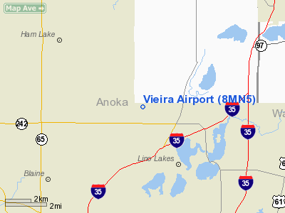
| From nearest city: | 2 nautical miles W of Lino Lakes, MN |
| Location: | Anoka County, MN |
| Magnetic Variation: | 03E (1985) |
Owner & Manager
| Ownership: | Privately owned |
| Owner: | Alfred F. Vieira |
| Address: | 14467 186th Ave
Elk River, MN 55330 |
| Phone number: | 612-786-2796 |
| Manager: | Dan Vieira |
| Address: | 1446 186th Ave Nw
Elk River, MN 55330 |
| Phone number: | 763-441-9843 |
Airport Operations and Facilities
| Airport Use: | Private
PERSONAL USE. |
| Wind indicator: | Yes |
| Segmented Circle: | No |
| Control Tower: | No |
| Landing fee charge: | No |
| Sectional chart: | Twin Cities |
| Region: | AGL - Great Lakes |
| Boundary ARTCC: | ZMP - Minneapolis |
| Tie-in FSS: | PNM - Princeton |
| FSS on Airport: | No |
| FSS Toll Free: | 1-800-WX-BRIEF |
Runway Information
Runway N/S
| Dimension: | 2000 x 30 ft / 609.6 x 9.1 m |
| Surface: | TURF, |
| |
Runway N |
Runway S |
| Traffic Pattern: | Left | Left |
|
Radio Navigation Aids
| ID |
Type |
Name |
Ch |
Freq |
Var |
Dist |
| OEO | NDB | Osceola | | 233.00 | 01E | 19.8 nm |
| CBG | NDB | Cambridge | | 350.00 | 03E | 21.7 nm |
| PPI | NDB | Hopey | | 400.00 | 03E | 21.7 nm |
| MS | NDB | Narco | | 266.00 | 02E | 23.1 nm |
| RNH | NDB | New Richmond | | 257.00 | 02E | 25.7 nm |
| PNM | NDB | Princeton | | 368.00 | 03E | 29.3 nm |
| ROS | NDB | Rush City | | 282.00 | 02E | 30.3 nm |
| AHH | NDB | Ameron | | 278.00 | 01E | 32.6 nm |
| JMR | NDB | Mora | | 327.00 | 03E | 41.4 nm |
| GYL | NDB | Glencoe | | 407.00 | 03E | 48.6 nm |
| BXR | NDB | Big Doctor | | 203.00 | 02E | 49.0 nm |
| MSP | VOR/DME | Minneapolis | 100X | 115.30 | 02E | 19.2 nm |
| FCM | VOR/DME | Flying Cloud | 055X | 111.80 | 06E | 26.8 nm |
| STC | VOR/DME | St Cloud | 058X | 112.10 | 03E | 44.1 nm |
| RZN | VOR/DME | Siren | 031X | 109.40 | 02E | 48.7 nm |
| GEP | VORTAC | Gopher | 120X | 117.30 | 06E | 10.8 nm |
| FGT | VORTAC | Farmington | 104X | 115.70 | 06E | 34.8 nm |
| STP | VOT | St Paul | | 114.40 | | 16.4 nm |
| MSP | VOT | Minneapolis St Paul | | 111.00 | | 19.8 nm |
Remarks
- UPON ACTIVATION OF HAM LAKE ARPT THIS FACILITY IS SUBJECT TO ABANDONMENT.
Images and information placed above are from
http://www.airport-data.com/airport/8MN5/
We thank them for the data!
| General Info
|
| Country |
United States
|
| State |
MINNESOTA
|
| FAA ID |
8MN5
|
| Latitude |
45-12-29.878N
|
| Longitude |
093-08-00.804W
|
| Elevation |
900 feet
|
| Near City |
LINO LAKES
|
We don't guarantee the information is fresh and accurate. The data may
be wrong or outdated.
For more up-to-date information please refer to other sources.
|
|


