 |
|
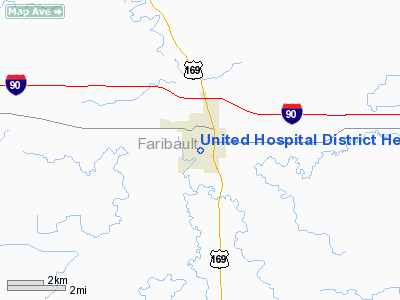
United Hospital District Heliport |
Location & QuickFacts
| FAA Information Effective: | 2008-09-25 |
| Airport Identifier: | MN14 |
| Airport Status: | Operational |
| Longitude/Latitude: | 094-06-00.3550W/43-38-01.3380N
-94.100099/43.633705 (Estimated) |
| Elevation: | 1089 ft / 331.93 m (Estimated) |
| Land: | 0 acres |
| From nearest city: | 0 nautical miles N of Blue Earth, MN |
| Location: | Faribault County, MN |
| Magnetic Variation: | 04E (1990) |
Owner & Manager
| Ownership: | Privately owned |
| Owner: | United Hospital District |
| Address: | 515 S Moore
Blue Earth, MN 56013 |
| Phone number: | 507-526-3273 |
| Manager: | David Classon |
| Address: | 515 S Moore
Blue Earth, MN 56013 |
| Phone number: | 507-526-3273 |
Airport Operations and Facilities
| Airport Use: | Private
MEDICAL USE. |
| Wind indicator: | Yes |
| Segmented Circle: | No |
| Control Tower: | No |
| Sectional chart: | Omaha |
| Region: | AGL - Great Lakes |
| Boundary ARTCC: | ZMP - Minneapolis |
| Tie-in FSS: | PNM - Princeton |
| FSS Toll Free: | 1-800-WX-BRIEF |
Runway Information
Helipad H1
| Dimension: | 113 x 98 ft / 34.4 x 29.9 m |
| Surface: | ASPH, |
| |
Runway H1 |
Runway |
| Traffic Pattern: | Left | Left |
|
Radio Navigation Aids
| ID |
Type |
Name |
Ch |
Freq |
Var |
Dist |
| SBU | NDB | Blue Earth | | 332.00 | 04E | 2.2 nm |
| JYG | NDB | St James | | 260.00 | 04E | 28.8 nm |
| FXY | NDB | Forest City | | 359.00 | 05E | 31.8 nm |
| PUF | NDB | Puff | | 345.00 | 04E | 32.6 nm |
| AXA | NDB | Algona | | 403.00 | 03E | 34.0 nm |
| ACQ | NDB | Waseca | | 371.00 | 02E | 35.4 nm |
| MJQ | NDB | Jackson | | 353.00 | 04E | 38.5 nm |
| EGQ | NDB | Emmetsburg | | 410.00 | 04E | 41.6 nm |
| MWM | NDB | Windom | | 203.00 | 03E | 46.8 nm |
| ULM | NDB/DME | New Ulm | 050X | 272.00 | 04E | 44.6 nm |
| EST | VOR | Estherville | | 110.40 | 07E | 31.2 nm |
| FRM | VOR/DME | Fairmont | 039X | 110.20 | 07E | 14.0 nm |
| AEL | VOR/DME | Albert Lea | 035X | 109.80 | 05E | 31.8 nm |
| MKT | VOR/DME | Mankato | 045X | 110.80 | 07E | 36.2 nm |
| FOW | VOR/DME | Halfway | 049X | 111.20 | 02E | 46.6 nm |
| MCW | VORTAC | Mason City | 096X | 114.90 | 06E | 46.7 nm |
Remarks
- OPERS ARE CONDUCTED FM 127 TO 140 DEG & FM 325 TO 335 DEG; AREA IS MKD; WIND IND IS MAINTAINED; COMMUNICATIONS & WRITTEN PROCEDURES BE ESTABLISHED FOR SECURITY & UNAUTHORIZED PERSONS BE RESTRAINED.
Images and information placed above are from
http://www.airport-data.com/airport/MN14/
We thank them for the data!
| General Info
|
| Country |
United States
|
| State |
MINNESOTA
|
| FAA ID |
MN14
|
| Latitude |
43-38-01.338N
|
| Longitude |
094-06-00.355W
|
| Elevation |
1089 feet
|
| Near City |
BLUE EARTH
|
We don't guarantee the information is fresh and accurate. The data may
be wrong or outdated.
For more up-to-date information please refer to other sources.
|
|


