 |
|
Location & QuickFacts
| FAA Information Effective: | 2008-09-25 |
| Airport Identifier: | 9MN1 |
| Airport Status: | Operational |
| Longitude/Latitude: | 093-11-50.8040W/45-36-41.8640N
-93.197446/45.611629 (Estimated) |
| Elevation: | 960 ft / 292.61 m (Estimated) |
| Land: | 80 acres |
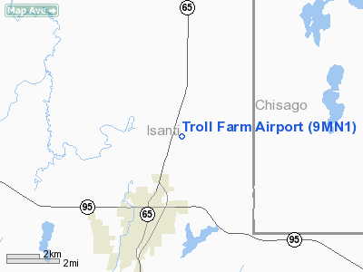
| From nearest city: | 5 nautical miles N of Cambridge, MN |
| Location: | Isanti County, MN |
| Magnetic Variation: | 02E (1995) |
Owner & Manager
| Ownership: | Privately owned |
| Owner: | John C Troolin |
| Address: | 35499 Bataan St Ne
Cambridge, MN 55008 |
| Phone number: | 612-689-5690 |
| Manager: | John C Troolin |
| Address: | 35499 Bataan St Ne
Cambridge, MN 55008 |
| Phone number: | 612-689-5890 |
Airport Operations and Facilities
| Airport Use: | Private |
| Wind indicator: | Yes |
| Segmented Circle: | No |
| Control Tower: | No |
| Sectional chart: | Twin Cities |
| Region: | AGL - Great Lakes |
| Boundary ARTCC: | ZMP - Minneapolis |
| Tie-in FSS: | PNM - Princeton |
| FSS on Airport: | No |
| FSS Toll Free: | 1-800-WX-BRIEF |
Runway Information
Runway 09/27
| Dimension: | 2100 x 75 ft / 640.1 x 22.9 m |
| Surface: | TURF, |
| |
Runway 09 |
Runway 27 |
| Traffic Pattern: | Left | Left |
|
Radio Navigation Aids
| ID |
Type |
Name |
Ch |
Freq |
Var |
Dist |
| CBG | NDB | Cambridge | | 350.00 | 03E | 4.2 nm |
| ROS | NDB | Rush City | | 282.00 | 02E | 11.4 nm |
| JMR | NDB | Mora | | 327.00 | 03E | 17.0 nm |
| PNM | NDB | Princeton | | 368.00 | 03E | 17.5 nm |
| OEO | NDB | Osceola | | 233.00 | 01E | 28.1 nm |
| BXR | NDB | Big Doctor | | 203.00 | 02E | 37.1 nm |
| RNH | NDB | New Richmond | | 257.00 | 02E | 39.6 nm |
| AHH | NDB | Ameron | | 278.00 | 01E | 40.1 nm |
| PPI | NDB | Hopey | | 400.00 | 03E | 45.7 nm |
| MS | NDB | Narco | | 266.00 | 02E | 47.5 nm |
| STC | VOR/DME | St Cloud | 058X | 112.10 | 03E | 36.4 nm |
| RZN | VOR/DME | Siren | 031X | 109.40 | 02E | 36.7 nm |
| MSP | VOR/DME | Minneapolis | 100X | 115.30 | 02E | 43.0 nm |
| FCM | VOR/DME | Flying Cloud | 055X | 111.80 | 06E | 48.5 nm |
| GEP | VORTAC | Gopher | 120X | 117.30 | 06E | 29.0 nm |
| STP | VOT | St Paul | | 114.40 | | 40.7 nm |
| MSP | VOT | Minneapolis St Paul | | 111.00 | | 43.7 nm |
Remarks
- PRVDD OBSTN IS LOWERED OR REMOVED OR THLD DSPLCD TO TRVD A CLEAR 20:1 APCH; THE OFZ & AREA 125 FT EITHER SIDE OF RWY & 200 FT OFF RY ENDS IS CLEAR; THE RWY SAFETY AREA IS CLEAR.
Images and information placed above are from
http://www.airport-data.com/airport/9MN1/
We thank them for the data!
| General Info
|
| Country |
United States
|
| State |
MINNESOTA
|
| FAA ID |
9MN1
|
| Latitude |
45-36-41.864N
|
| Longitude |
093-11-50.804W
|
| Elevation |
960 feet
|
| Near City |
CAMBRIDGE
|
We don't guarantee the information is fresh and accurate. The data may
be wrong or outdated.
For more up-to-date information please refer to other sources.
|
|


