 |
|
Thief River Falls Regional Airport |
| Thief River Falls Regional Airport |
| IATA: TVF – ICAO: KTVF |
| Summary |
| Airport type |
Public |
| Operator |
City of Thief River Falls |
| Location |
Thief River Falls, Minnesota |
| Elevation AMSL |
1,116 ft / 340.2 m |
| Coordinates |
48°03′56″N 96°11′06″W / 48.06556°N 96.185°W / 48.06556; -96.185Coordinates: 48°03′56″N 96°11′06″W / 48.06556°N 96.185°W / 48.06556; -96.185 |
| Runways |
| Direction |
Length |
Surface |
| ft |
m |
| 13/31 |
6,503 |
1,982 |
Asphalt |
| 3/21 |
4,997 |
1,523 |
Asphalt |
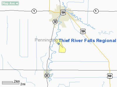
Thief River Falls Regional Airport (IATA: TVF, ICAO: KTVF) is a public airport located three miles (5 km) south of the central business district (CBD) of Thief River Falls, a city in Pennington County, Minnesota, USA. The airport covers 916 acres (371 ha) and has two runways. It is mostly used for general aviation but is also served by one commercial airline. Service is subsidized by the Essential Air Service program. Airlines and destinations
| Airlines |
Destinations |
| Delta Connection operated by Mesaba Airlines |
Hibbing, Minneapolis/St. Paul |
Cargo
| Airlines |
Destinations |
| FedEx Feeder operated by Corporate Air |
Grand Forks |
The above content comes from Wikipedia and is published under free licenses – click here to read more.
Location & QuickFacts
| FAA Information Effective: | 2008-09-25 |
| Airport Identifier: | TVF |
| Airport Status: | Operational |
| Longitude/Latitude: | 096-11-06.0000W/48-03-56.4000N
-96.185000/48.065667 (Estimated) |
| Elevation: | 1119 ft / 341.07 m (Surveyed) |
| Land: | 916 acres |
| From nearest city: | 3 nautical miles S of Thief River Falls, MN |
| Location: | Pennington County, MN |
| Magnetic Variation: | 05E (1985) |
Owner & Manager
| Ownership: | Publicly owned |
| Owner: | City Of Thief River Falls |
| Address: | 405 Third St E
Thief River Falls, MN 56701 |
| Phone number: | 218-681-8506 |
| Manager: | Ronald Lindberg
ARPT SUP MARK JOSEPHSON 218-681-7680. |
| Address: | Thief River Falls Arpt, #13722
Thief River Falls, MN 56701 |
| Phone number: | 218-681-7680 |
Airport Operations and Facilities
| Airport Use: | Open to public |
| Wind indicator: | Yes |
| Segmented Circle: | No |
| Control Tower: | No |
| Lighting Schedule: | DUSK-DAWN
ACTVT HIRL RY 13/31, MIRL RY 03/21, REIL RYS 13, 03 & 21 & MALSR RY 31 - CTAF. |
| Beacon Color: | Clear-Green (lighted land airport) |
| Landing fee charge: | No |
| Sectional chart: | Twin Cities |
| Region: | AGL - Great Lakes |
| Boundary ARTCC: | ZMP - Minneapolis |
| Tie-in FSS: | PNM - Princeton |
| FSS on Airport: | No |
| FSS Toll Free: | 1-800-WX-BRIEF |
| NOTAMs Facility: | TVF (NOTAM-d service avaliable) |
| Certification type/date: | I A S 05/1973
48 HR PPR FOR UNSKED ACR OPNS WITH MORE THAN 30 PSGR SEATS CALL AMGR (218) 681-7680. SCHEDULED ACR OPS GREATER THAN 9 PSGR SEATS IN EXCESS OF 15 MINUTES FROM PUBLISHED TIMES MUST CTC ARPT TO ENSURE ARFF IS AVBL PRIOR TO ACR OPNS. |
| Federal Agreements: | NGY |
Airport Communications
| CTAF: | 122.800 |
| Unicom: | 122.800 |
Airport Services
| Fuel available: | 100LLA |
| Airframe Repair: | MAJOR |
| Power Plant Repair: | MAJOR |
Runway Information
Runway 03/21
| Dimension: | 4997 x 75 ft / 1523.1 x 22.9 m |
| Surface: | ASPH, Good Condition |
| Surface Treatment: | Saw-cut or plastic Grooved |
| Weight Limit: | Dual wheel: 30000 lbs. |
| Edge Lights: | Medium |
| |
Runway 03 |
Runway 21 |
| Longitude: | 096-11-34.2408W | 096-10-47.7375W |
| Latitude: | 48-03-42.0331N | 48-04-20.2390N |
| Elevation: | 1112.00 ft | 1118.00 ft |
| Alignment: | 39 | 127 |
| Traffic Pattern: | Left | Left |
| Crossing Height: | 34.00 ft | 34.00 ft |
| VASI: | 4-light PAPI on left side | 4-light PAPI on left side |
| Runway End Identifier: | Yes | Yes |
|
Runway 13/31
| Dimension: | 6503 x 150 ft / 1982.1 x 45.7 m |
| Surface: | ASPH, Fair Condition |
| Surface Treatment: | Saw-cut or plastic Grooved |
| Weight Limit: | Single wheel: 75000 lbs.
Dual wheel: 90000 lbs.
Dual tandem wheel: 155000 lbs. |
| Edge Lights: | High |
| |
Runway 13 |
Runway 31 |
| Longitude: | 096-11-36.1223W | 096-10-28.1556W |
| Latitude: | 48-04-15.4264N | 48-03-30.2261N |
| Elevation: | 1115.00 ft | 1114.00 ft |
| Alignment: | 127 | 127 |
| ILS Type: | | ILS
|
| Traffic Pattern: | Left | Left |
| Markings: | Precision instrument, Good Condition | Precision instrument, Good Condition |
| Crossing Height: | 40.00 ft | 55.00 ft |
| VASI: | 4-light PAPI on left side | 4-light PAPI on left side |
| Visual Glide Angle: | 3.00° | 3.00° |
| Approach lights: | | MALSR |
| Runway End Identifier: | Yes | |
| Obstruction: | 45 ft trees, 2200.0 ft from runway, 200 ft left of centerline, 44:1 slope to clear | , 50:1 slope to clear |
|
Radio Navigation Aids
| ID |
Type |
Name |
Ch |
Freq |
Var |
Dist |
| CKN | NDB | Crookston | | 400.00 | 07E | 22.0 nm |
| FSE | NDB | Fosston | | 224.00 | 05E | 33.2 nm |
| RDR | TACAN | Red River | 111X | | 06E | 49.5 nm |
| TVF | VOR/DME | Thief River Falls | 021X | 108.40 | 08E | 0.2 nm |
| GFK | VOR/DME | Grand Forks | 090X | 114.30 | 09E | 40.8 nm |
Remarks
Images and information placed above are from
http://www.airport-data.com/airport/TVF/
We thank them for the data!
| General Info
|
| Country |
United States
|
| State |
MINNESOTA
|
| FAA ID |
TVF
|
| Latitude |
48-03-55.801N
|
| Longitude |
096-11-00.099W
|
| Elevation |
1116 feet
|
| Near City |
THIEF RIVER FALLS
|
We don't guarantee the information is fresh and accurate. The data may
be wrong or outdated.
For more up-to-date information please refer to other sources.
|
|


