 |
|
|
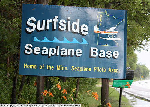 |
(Click on the photo to enlarge) |
Location & QuickFacts
| FAA Information Effective: | 2008-09-25 |
| Airport Identifier: | 8Y4 |
| Airport Status: | Operational |
| Longitude/Latitude: | 093-07-00.8000W/45-08-59.8780N
-93.116889/45.149966 (Estimated) |
| Elevation: | 880 ft / 268.22 m (Estimated) |
| Land: | 20 acres |
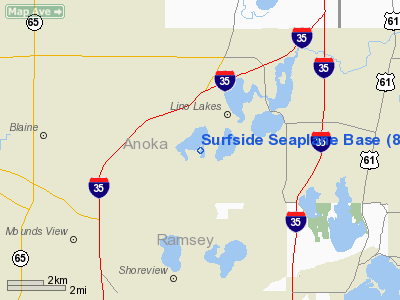
| From nearest city: | 2 nautical miles S of Lino Lakes, MN |
| Location: | Anoka County, MN |
| Magnetic Variation: | 03E (1985) |
Owner & Manager
| Ownership: | Privately owned |
| Owner: | Surfside Seaplane Base Inc |
| Address: | 6980 Lake Dr
Lino Lakes, MN 55014 |
| Phone number: | 612-780-4179 |
| Manager: | Bruce R. Hanson |
| Address: | 6980 Lake Dr
Lino Lakes, MN 55014 |
| Phone number: | 612-780-4179 |
Airport Operations and Facilities
| Airport Use: | Open to public |
| Wind indicator: | Yes |
| Segmented Circle: | No |
| Control Tower: | No |
| Landing fee charge: | No |
| Sectional chart: | Twin Cities |
| Region: | AGL - Great Lakes |
| Traffic Pattern Alt: | 600 ft |
| Boundary ARTCC: | ZMP - Minneapolis |
| Tie-in FSS: | PNM - Princeton |
| FSS on Airport: | No |
| FSS Toll Free: | 1-800-WX-BRIEF |
| NOTAMs Facility: | PNM (NOTAM-d service avaliable) |
Airport Communications
Airport Services
| Fuel available: | 100LL |
| Airframe Repair: | MAJOR |
| Power Plant Repair: | MAJOR |
Runway Information
Runway N/S
| Dimension: | 5500 x 1000 ft / 1676.4 x 304.8 m |
| Surface: | WATER, |
| |
Runway N |
Runway S |
| Traffic Pattern: | Left | Left |
|
Runway NE/SW
| Dimension: | 6500 x 1000 ft / 1981.2 x 304.8 m |
| Surface: | WATER, |
| |
Runway NE |
Runway SW |
| Traffic Pattern: | Left | Left |
|
Radio Navigation Aids
| ID |
Type |
Name |
Ch |
Freq |
Var |
Dist |
| PPI | NDB | Hopey | | 400.00 | 03E | 18.2 nm |
| MS | NDB | Narco | | 266.00 | 02E | 19.5 nm |
| OEO | NDB | Osceola | | 233.00 | 01E | 20.6 nm |
| RNH | NDB | New Richmond | | 257.00 | 02E | 24.7 nm |
| CBG | NDB | Cambridge | | 350.00 | 03E | 25.3 nm |
| PNM | NDB | Princeton | | 368.00 | 03E | 32.4 nm |
| AHH | NDB | Ameron | | 278.00 | 01E | 32.5 nm |
| ROS | NDB | Rush City | | 282.00 | 02E | 33.6 nm |
| JMR | NDB | Mora | | 327.00 | 03E | 45.0 nm |
| GYL | NDB | Glencoe | | 407.00 | 03E | 47.4 nm |
| MSP | VOR/DME | Minneapolis | 100X | 115.30 | 02E | 16.1 nm |
| FCM | VOR/DME | Flying Cloud | 055X | 111.80 | 06E | 24.3 nm |
| STC | VOR/DME | St Cloud | 058X | 112.10 | 03E | 46.5 nm |
| GEP | VORTAC | Gopher | 120X | 117.30 | 06E | 10.9 nm |
| FGT | VORTAC | Farmington | 104X | 115.70 | 06E | 31.3 nm |
| STP | VOT | St Paul | | 114.40 | | 12.8 nm |
| MSP | VOT | Minneapolis St Paul | | 111.00 | | 16.5 nm |
Remarks
- PLAN APCH OVER MARSHAN OR BALDWIN LAKES.
- 500' TWR 2 MI EAST RIGHT OF DEP PATH.
- SOUTH DEPS MAKE LEFT TURNOUT.
Images and information placed above are from
http://www.airport-data.com/airport/8Y4/
We thank them for the data!
| General Info
|
| Country |
United States
|
| State |
MINNESOTA
|
| FAA ID |
8Y4
|
| Latitude |
45-08-59.878N
|
| Longitude |
093-07-00.800W
|
| Elevation |
880 feet
|
| Near City |
LINO LAKES
|
We don't guarantee the information is fresh and accurate. The data may
be wrong or outdated.
For more up-to-date information please refer to other sources.
|
|


