 |
|
| Stanton Airfield |
| IATA: SYN – ICAO: KSYN – FAA LID: SYN |
| Summary |
| Airport type |
Public |
| Owner |
Stanton Sport Aviation, Inc. |
| Serves |
Stanton, Minnesota |
| Elevation AMSL |
920 ft / 280 m |
| Coordinates |
44°28′32″N 093°00′59″W / 44.47556°N 93.01639°W / 44.47556; -93.01639 |
| Website |
StantonAirfield.com |
| Runways |
| Direction |
Length |
Surface |
| ft |
m |
| 9/27 |
1,970 |
600 |
Turf |
| 18/36 |
2,550 |
777 |
Turf |
| Statistics (2007) |
| Aircraft operations |
15,000 |
| Based aircraft |
47 |
| Sources: Minnesota DOT, FAA |
Stanton Airfield (IATA: SYN, ICAO: KSYN, FAA LID: SYN) is a public use airport located one nautical mile (1.85 km) east of the central business district of Stanton, in Goodhue County, Minnesota, United States. The airport is privately owned by Stanton Sport Aviation, Inc. History
Carleton Airport has been in operation since 1942, when Carleton College bought a farm to use as an airport to train pilots for World War II. In 1944, the college leased the field to Triangle Aviation, operated by Malcolm and Margaret Manuel, which eventually bought the airport in 1955. In 1990, Stanton Sport Aviation was formed to purchase the airport. The airport was added to the National Register of Historic Places in 2004.
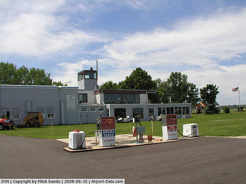
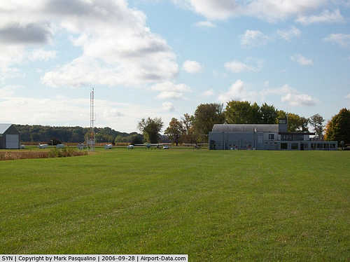
Facilities and aircraft
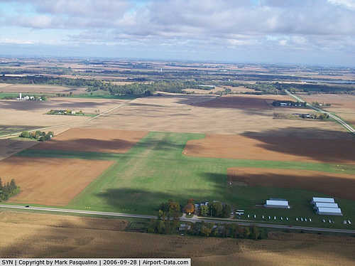
Stanton Airfield covers an area of 158 acres (64 ha) at an elevation of 920 feet (280 m) above mean sea level. It has two runways with turf surfaces: 9/27 is 1,970 by 180 feet (600 x 55 m) and 18/36 is 2,550 by 200 feet (777 x 61 m).
For the 12-month period ending August 31, 2007, the airport had 15,000 general aviation aircraft operations, an average of 41 per day. At that time there were 47 aircraft based at this airport: 36% single-engine and 64% glider.
The above content comes from Wikipedia and is published under free licenses – click here to read more.

|
 |
(Click on the photo to enlarge) |
|
 |
(Click on the photo to enlarge) |
|
 |
(Click on the photo to enlarge) |
Location & QuickFacts
| FAA Information Effective: | 2008-09-25 |
| Airport Identifier: | SYN |
| Airport Status: | Operational |
| Longitude/Latitude: | 093-00-58.7580W/44-28-31.8800N
-93.016322/44.475522 (Estimated) |
| Elevation: | 920 ft / 280.42 m (Estimated) |
| Land: | 158 acres |
| From nearest city: | 1 nautical miles E of Stanton, MN |
| Location: | Goodhue County, MN |
| Magnetic Variation: | 03E (1985) |
Owner & Manager
| Ownership: | Privately owned |
| Owner: | Stanton Sport Aviation Inc |
| Address: | 1235 Hwy 19
Stanton, MN 55018 |
| Phone number: | 507-645-4030 |
| Manager: | Kent Johnson |
| Address: | 1235 Hwy 19
Stanton, MN 55018 |
| Phone number: | 507-645-4030 |
Airport Operations and Facilities
| Airport Use: | Open to public |
| Wind indicator: | Yes |
| Segmented Circle: | No |
| Control Tower: | No |
| Landing fee charge: | No |
| Sectional chart: | Omaha |
| Region: | AGL - Great Lakes |
| Traffic Pattern Alt: | 800 ft |
| Boundary ARTCC: | ZMP - Minneapolis |
| Tie-in FSS: | PNM - Princeton |
| FSS on Airport: | No |
| FSS Toll Free: | 1-800-WX-BRIEF |
| NOTAMs Facility: | SYN (NOTAM-d service avaliable) |
Airport Communications
| CTAF: | 122.800 |
| Unicom: | 122.800 |
Airport Services
| Fuel available: | 100LLMOGAS |
| Airframe Repair: | MAJOR |
| Power Plant Repair: | MAJOR |
| Bottled Oxygen: | NONE |
| Bulk Oxygen: | NONE |
Runway Information
Runway 09/27
| Dimension: | 1970 x 180 ft / 600.5 x 54.9 m |
| Surface: | TURF, Good Condition |
| |
Runway 09 |
Runway 27 |
| Longitude: | 093-01-12.5200W | 093-00-44.9900W |
| Latitude: | 44-28-31.8700N | 44-28-31.8800N |
| Elevation: | 920.00 ft | 920.00 ft |
| Traffic Pattern: | Left | Left |
| Obstruction: | 34 ft trees, 700.0 ft from runway, 100 ft right of centerline, 20:1 slope to clear | 15 ft road, 671.0 ft from runway, 44:1 slope to clear |
|
Runway 18/36
| Dimension: | 2550 x 200 ft / 777.2 x 61.0 m |
| Surface: | TURF, Good Condition |
| |
Runway 18 |
Runway 36 |
| Longitude: | 093-00-58.7500W | 093-00-58.7500W |
| Latitude: | 44-28-44.6300N | 44-28-19.1300N |
| Elevation: | 920.00 ft | 920.00 ft |
| Traffic Pattern: | Left | Left |
| Displaced threshold: | 0.00 ft | 300.00 ft |
| Obstruction: | 125 ft hill, 6200.0 ft from runway, 600 ft right of centerline, 49:1 slope to clear | 17 ft road, 50.0 ft from runway, 2:1 slope to clear
APCH SLOPE 20:1 TO DSPLD THLD. |
|
Radio Navigation Aids
| ID |
Type |
Name |
Ch |
Freq |
Var |
Dist |
| MS | NDB | Narco | | 266.00 | 02E | 21.3 nm |
| PPI | NDB | Hopey | | 400.00 | 03E | 24.1 nm |
| ACQ | NDB | Waseca | | 371.00 | 02E | 33.6 nm |
| RNH | NDB | New Richmond | | 257.00 | 02E | 45.3 nm |
| GYL | NDB | Glencoe | | 407.00 | 03E | 48.9 nm |
| FOW | VOR/DME | Halfway | 049X | 111.20 | 02E | 22.3 nm |
| MSP | VOR/DME | Minneapolis | 100X | 115.30 | 02E | 27.0 nm |
| FCM | VOR/DME | Flying Cloud | 055X | 111.80 | 06E | 28.2 nm |
| MKT | VOR/DME | Mankato | 045X | 110.80 | 07E | 41.5 nm |
| RST | VOR/DME | Rochester | 057X | 112.00 | 05E | 45.4 nm |
| FGT | VORTAC | Farmington | 104X | 115.70 | 06E | 11.7 nm |
| GEP | VORTAC | Gopher | 120X | 117.30 | 06E | 43.1 nm |
| MSP | VOT | Minneapolis St Paul | | 111.00 | | 26.0 nm |
| STP | VOT | St Paul | | 114.40 | | 28.0 nm |
Remarks
- GLIDER OPNS ON & INVOF ARPT; SFC THRU 8000 FT MSL WKENDS DURING DALGT HRS EXCEPT WINTER MONTHS.
- SEASONAL CROPS RYS 09; 27; 18 SLOPE 0:1 WHEN CROPS PRESENT.
- ESTAB PRIOR TO 1959.
Images and information placed above are from
http://www.airport-data.com/airport/SYN/
We thank them for the data!
| General Info
|
| Country |
United States
|
| State |
MINNESOTA
|
| FAA ID |
SYN
|
| Latitude |
44-28-31.880N
|
| Longitude |
093-00-58.758W
|
| Elevation |
920 feet
|
| Near City |
STANTON
|
We don't guarantee the information is fresh and accurate. The data may
be wrong or outdated.
For more up-to-date information please refer to other sources.
|
|


