 |
|
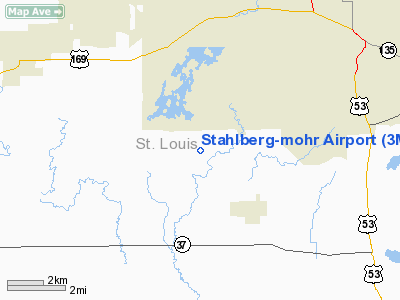
Location & QuickFacts
| FAA Information Effective: | 2008-09-25 |
| Airport Identifier: | 3MN1 |
| Airport Status: | Operational |
| Longitude/Latitude: | 092-38-41.6610W/47-26-54.7450N
-92.644906/47.448540 (Estimated) |
| Elevation: | 1380 ft / 420.62 m (Estimated) |
| Land: | 0 acres |
| From nearest city: | 2 nautical miles NW of Iron Junction, MN |
| Location: | St Louis County, MN |
| Magnetic Variation: | 02E (1985) |
Owner & Manager
| Ownership: | Privately owned
JOINT OWNERSHIP - JOHN & MARILYN MOHR, RT 2 BOX 10B, IRON MN 55751, 218-744-2449. |
| Owner: | Virgil & Linda Stahlberg |
| Address: | 4391 Baker Rd
Iron, MN 55751 |
| Phone number: | 218-744-5309 |
| Address: |
|
Airport Operations and Facilities
| Airport Use: | Private |
| Wind indicator: | Yes |
| Segmented Circle: | No |
| Control Tower: | No |
| Landing fee charge: | No |
| Sectional chart: | Green Bay |
| Region: | AGL - Great Lakes |
| Boundary ARTCC: | ZMP - Minneapolis |
| Tie-in FSS: | PNM - Princeton |
| FSS on Airport: | No |
| FSS Toll Free: | 1-800-WX-BRIEF |
Runway Information
Runway 14/32
| Dimension: | 3400 x 150 ft / 1036.3 x 45.7 m |
| Surface: | TURF, |
| |
Runway 14 |
Runway 32 |
| Traffic Pattern: | Left | Left |
|
Radio Navigation Aids
| ID |
Type |
Name |
Ch |
Freq |
Var |
Dist |
| CQM | NDB | Cook | | 233.00 | 01E | 22.5 nm |
| ORB | NDB | Orr | | 341.00 | 02E | 35.4 nm |
| DL | NDB | Pykla | | 379.00 | 02E | 38.1 nm |
| TWM | NDB | Two Harbors | | 243.00 | 01E | 43.8 nm |
| COQ | NDB | Cloquet | | 335.00 | 03E | 45.5 nm |
| FOZ | NDB | Bigfork | | 345.00 | 02E | 45.6 nm |
| SCG | NDB | Scott | | 385.00 | 02E | 49.3 nm |
| LKI | TACAN | Lakeside | 011X | | 05E | 40.9 nm |
| EVM | VOR/DME | Eveleth | 019X | 108.20 | 01E | 6.1 nm |
| HIB | VOR/DME | Hibbing | 045X | 110.80 | 02E | 9.2 nm |
| GPZ | VOR/DME | Grand Rapids | 051X | 111.40 | 06E | 38.4 nm |
| ELO | VOR/DME | Ely | 033X | 109.60 | 00E | 39.9 nm |
| DLH | VORTAC | Duluth | 073X | 112.60 | 05E | 42.9 nm |
Images and information placed above are from
http://www.airport-data.com/airport/3MN1/
We thank them for the data!
| General Info
|
| Country |
United States
|
| State |
MINNESOTA
|
| FAA ID |
3MN1
|
| Latitude |
47-26-54.745N
|
| Longitude |
092-38-41.661W
|
| Elevation |
1380 feet
|
| Near City |
IRON JUNCTION
|
We don't guarantee the information is fresh and accurate. The data may
be wrong or outdated.
For more up-to-date information please refer to other sources.
|
|


