 |
|
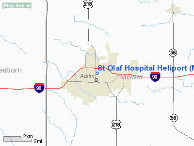
St Olaf Hospital Heliport |
Location & QuickFacts
| FAA Information Effective: | 2008-09-25 |
| Airport Identifier: | MN34 |
| Airport Status: | Operational |
| Longitude/Latitude: | 092-58-37.6920W/43-40-30.8660N
-92.977137/43.675241 (Estimated) |
| Elevation: | 1202 ft / 366.37 m (Estimated) |
| Land: | 0 acres |
| From nearest city: | 0 nautical miles E of Austin, MN |
| Location: | Mower County, MN |
| Magnetic Variation: | 03E (1990) |
Owner & Manager
| Ownership: | Privately owned |
| Owner: | Austin Medical Center |
| Address: | 300 8th Avenue
Austin, MN 55912 |
| Phone number: | 507-437-4551 |
| Manager: | Timothy Schneider
(OTHER CONTACT) SHELLY METCALF; 507-437-4451 |
| Address: | 300 8th Avenue Nw
Austin, MN 55912 |
| Phone number: | 507-437-4551 |
Airport Operations and Facilities
| Airport Use: | Private
MEDICAL USE. |
| Wind indicator: | Yes |
| Segmented Circle: | No |
| Control Tower: | No |
| Lighting Schedule: | PHONE REQ
FOR PERIMETER & OBSTRUCTION LGTS CALL 507-437-4551. |
| Sectional chart: | Chicago |
| Region: | AGL - Great Lakes |
| Boundary ARTCC: | ZMP - Minneapolis |
| Tie-in FSS: | PNM - Princeton |
| FSS on Airport: | No |
| FSS Toll Free: | 1-800-WX-BRIEF |
Runway Information
Helipad H1
| Dimension: | 50 x 50 ft / 15.2 x 15.2 m |
| Surface: | CONC, |
| |
Runway H1 |
Runway |
| Traffic Pattern: | Left | Left |
|
Radio Navigation Aids
| ID |
Type |
Name |
Ch |
Freq |
Var |
Dist |
| IY | NDB | Chukk | | 417.00 | 03E | 34.3 nm |
| ACQ | NDB | Waseca | | 371.00 | 02E | 34.4 nm |
| FXY | NDB | Forest City | | 359.00 | 05E | 38.6 nm |
| CCY | NDB | Charles City | | 375.00 | 03E | 39.9 nm |
| CJJ | NDB | Cresco | | 293.00 | 02E | 41.3 nm |
| SBU | NDB | Blue Earth | | 332.00 | 04E | 48.9 nm |
| JAY | VOR/DME | Austin | 019X | 108.20 | 03E | 6.4 nm |
| AEL | VOR/DME | Albert Lea | 035X | 109.80 | 05E | 17.1 nm |
| RST | VOR/DME | Rochester | 057X | 112.00 | 05E | 17.7 nm |
| FOW | VOR/DME | Halfway | 049X | 111.20 | 02E | 36.1 nm |
| MCW | VORTAC | Mason City | 096X | 114.90 | 06E | 38.1 nm |
Remarks
- PRVDD APCH/DEP OPNS CONDUCTED 300-080 DEGS; TKOF/LNDG AREA APPROPRIATELY MKD; AND A NON-OBSTRUCTING WIND INDICATOR IS MAINTAINED.
Images and information placed above are from
http://www.airport-data.com/airport/MN34/
We thank them for the data!
| General Info
|
| Country |
United States
|
| State |
MINNESOTA
|
| FAA ID |
MN34
|
| Latitude |
43-40-30.866N
|
| Longitude |
092-58-37.692W
|
| Elevation |
1202 feet
|
| Near City |
AUSTIN
|
We don't guarantee the information is fresh and accurate. The data may
be wrong or outdated.
For more up-to-date information please refer to other sources.
|
|


