 |
|
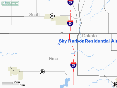
Sky Harbor Residential Airpark Airport |
|
 |
(Click on the photo to enlarge) |
Location & QuickFacts
| FAA Information Effective: | 2008-09-25 |
| Airport Identifier: | 1MN8 |
| Airport Status: | Operational |
| Longitude/Latitude: | 093-19-36.7990W/44-31-32.8700N
-93.326889/44.525797 (Estimated) |
| Elevation: | 1111 ft / 338.63 m (Surveyed) |
| Land: | 0 acres |
| From nearest city: | 1 nautical miles SE of Webster, MN |
| Location: | Rice County, MN |
| Magnetic Variation: | 03E (1985) |
Owner & Manager
| Ownership: | Privately owned |
| Owner: | Sky Harbor Airpark Inc. |
| Address: |
Webster, MN 55088 |
| Manager: | Larry U. Winn |
| Address: | 3279 45th Street West
Webster, MN 55088 |
| Phone number: | 612-461-2273 |
Airport Operations and Facilities
| Airport Use: | Private |
| Wind indicator: | Yes |
| Segmented Circle: | No |
| Control Tower: | No |
| Lighting Schedule: | DUSK-DAWN |
| Landing fee charge: | No |
| Sectional chart: | Twin Cities |
| Region: | AGL - Great Lakes |
| Boundary ARTCC: | ZMP - Minneapolis |
| Tie-in FSS: | PNM - Princeton |
| FSS on Airport: | No |
| FSS Toll Free: | 1-800-WX-BRIEF |
Airport Services
| Airframe Repair: | NONE |
| Power Plant Repair: | NONE |
Runway Information
Runway 12/30
| Dimension: | 2800 x 150 ft / 853.4 x 45.7 m |
| Surface: | TURF, |
| Edge Lights: | Low |
| |
Runway 12 |
Runway 30 |
| Traffic Pattern: | Right | Left |
|
Radio Navigation Aids
| ID |
Type |
Name |
Ch |
Freq |
Var |
Dist |
| MS | NDB | Narco | | 266.00 | 02E | 20.7 nm |
| PPI | NDB | Hopey | | 400.00 | 03E | 26.6 nm |
| ACQ | NDB | Waseca | | 371.00 | 02E | 29.1 nm |
| GYL | NDB | Glencoe | | 407.00 | 03E | 35.4 nm |
| HCD | NDB | Hutchinson | | 209.00 | 04E | 49.3 nm |
| FCM | VOR/DME | Flying Cloud | 055X | 111.80 | 06E | 18.9 nm |
| FOW | VOR/DME | Halfway | 049X | 111.20 | 02E | 19.4 nm |
| MSP | VOR/DME | Minneapolis | 100X | 115.30 | 02E | 22.6 nm |
| MKT | VOR/DME | Mankato | 045X | 110.80 | 07E | 31.2 nm |
| FGT | VORTAC | Farmington | 104X | 115.70 | 06E | 8.9 nm |
| GEP | VORTAC | Gopher | 120X | 117.30 | 06E | 37.3 nm |
| MSP | VOT | Minneapolis St Paul | | 111.00 | | 22.1 nm |
| STP | VOT | St Paul | | 114.40 | | 27.4 nm |
Remarks
- ALL TFC PAT OPERNS SHOULD BE CONDUCTED TO THE SOUTHWEST OF LNDG AREA.
Images and information placed above are from
http://www.airport-data.com/airport/1MN8/
We thank them for the data!
| General Info
|
| Country |
United States
|
| State |
MINNESOTA
|
| FAA ID |
1MN8
|
| Latitude |
44-31-32.870N
|
| Longitude |
093-19-36.799W
|
| Elevation |
1111 feet
|
| Near City |
WEBSTER
|
We don't guarantee the information is fresh and accurate. The data may
be wrong or outdated.
For more up-to-date information please refer to other sources.
|
|


