 |
|
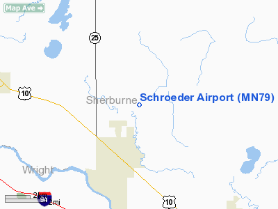
Location & QuickFacts
| FAA Information Effective: | 2008-09-25 |
| Airport Identifier: | MN79 |
| Airport Status: | Operational |
| Longitude/Latitude: | 093-51-27.9110W/45-25-52.8770N
-93.857753/45.431355 (Estimated) |
| Elevation: | 970 ft / 295.66 m (Estimated) |
| Land: | 2 acres |
| From nearest city: | 2 nautical miles N of Becker, MN |
| Location: | Sherburne County, MN |
| Magnetic Variation: | 04E (1990) |
Owner & Manager
| Ownership: | Privately owned |
| Owner: | Harold F & Elaine K Shroeder |
| Address: | 14688 97th St
Becker, MN 55038 |
| Phone number: | 612-261-5521 |
| Manager: | Harold F. Schroeder |
| Address: | 14688 97th St
Becker, MN 55038 |
| Phone number: | 612-261-5521 |
Airport Operations and Facilities
| Airport Use: | Private
PERSONAL USE. |
| Segmented Circle: | No |
| Control Tower: | No |
| Sectional chart: | Twin Cities |
| Region: | AGL - Great Lakes |
| Boundary ARTCC: | ZMP - Minneapolis |
| Tie-in FSS: | PNM - Princeton |
| FSS Toll Free: | 1-800-WX-BRIEF |
Runway Information
Runway 09/27
| Dimension: | 1470 x 50 ft / 448.1 x 15.2 m |
| Surface: | TURF, |
| |
Runway 09 |
Runway 27 |
| Traffic Pattern: | Left | Left |
| Obstruction: | | 474 ft tower, 6684.0 ft from runway |
|
Radio Navigation Aids
| ID |
Type |
Name |
Ch |
Freq |
Var |
Dist |
| PNM | NDB | Princeton | | 368.00 | 03E | 13.2 nm |
| CBG | NDB | Cambridge | | 350.00 | 03E | 26.2 nm |
| JMR | NDB | Mora | | 327.00 | 03E | 37.1 nm |
| LXL | NDB | Little Falls | | 359.00 | 03E | 37.2 nm |
| HCD | NDB | Hutchinson | | 209.00 | 04E | 41.1 nm |
| ROS | NDB | Rush City | | 282.00 | 02E | 41.2 nm |
| GYL | NDB | Glencoe | | 407.00 | 03E | 41.4 nm |
| XCR | NDB | Ripley | | 404.00 | 03E | 43.9 nm |
| MS | NDB | Narco | | 266.00 | 02E | 48.8 nm |
| OEO | NDB | Osceola | | 233.00 | 01E | 49.9 nm |
| RYM | TACAN | Camp Ripley | 048X | | 03E | 44.8 nm |
| STC | VOR/DME | St Cloud | 058X | 112.10 | 03E | 11.0 nm |
| FCM | VOR/DME | Flying Cloud | 055X | 111.80 | 06E | 40.2 nm |
| MSP | VOR/DME | Minneapolis | 100X | 115.30 | 02E | 41.6 nm |
| GEP | VORTAC | Gopher | 120X | 117.30 | 06E | 26.7 nm |
| DWN | VORTAC | Darwin | 027X | 109.00 | 07E | 32.6 nm |
| MSP | VOT | Minneapolis St Paul | | 111.00 | | 42.7 nm |
| STP | VOT | St Paul | | 114.40 | | 44.9 nm |
Remarks
- PRVDD ANY OBST IN RY APCH SLOPE SFC BE LWRD/REMOVED. OTHERWISE THE RY THR(S) SHD BE DSPLCD & CLRLY MKD SO AS TO PRVD A MIN 20:1 APCH CLNC OVER ALL OBSTNS. THE AREA 125' EITHER SIDE OF RY CNTRLN BE CLEAR OF AY OBSTN. THE RY W END BE RELCTD 200' AWAY FM THE PUBLIC-USE RD TO THE W.
Images and information placed above are from
http://www.airport-data.com/airport/MN79/
We thank them for the data!
| General Info
|
| Country |
United States
|
| State |
MINNESOTA
|
| FAA ID |
MN79
|
| Latitude |
45-25-52.877N
|
| Longitude |
093-51-27.911W
|
| Elevation |
970 feet
|
| Near City |
BECKER
|
We don't guarantee the information is fresh and accurate. The data may
be wrong or outdated.
For more up-to-date information please refer to other sources.
|
|


