 |
|
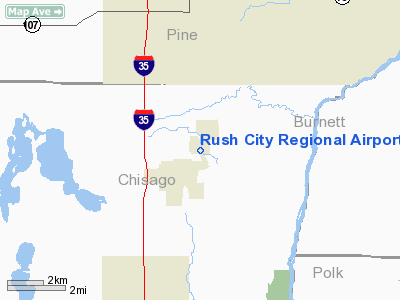
Rush City Regional Airport |
Location & QuickFacts
| FAA Information Effective: | 2008-09-25 |
| Airport Identifier: | ROS |
| Airport Status: | Operational |
| Longitude/Latitude: | 092-57-07.8000W/45-41-49.7000N
-92.952167/45.697139 (Estimated) |
| Elevation: | 926 ft / 282.24 m (Surveyed) |
| Land: | 156 acres |
| From nearest city: | 1 nautical miles NE of Rush City, MN |
| Location: | Chisago County, MN |
| Magnetic Variation: | 02E (2000) |
Owner & Manager
| Ownership: | Publicly owned |
| Owner: | City Of Rush City |
| Address: | Box 556
Rush City, MN 55069 |
| Phone number: | 612-358-4744 |
| Manager: | Howard Hanson |
| Address: | 54175 Forest Blvd.
Rush City, MN 55069 |
| Phone number: | 320-358-3333 |
Airport Operations and Facilities
| Airport Use: | Open to public |
| Wind indicator: | Yes |
| Segmented Circle: | No |
| Control Tower: | No |
| Lighting Schedule: | DUSK-DAWN
ACTVT MIRL RY 16/34, PAPI RYS 16 & 34, & REIL RYS 16 & 34 - CTAF |
| Beacon Color: | Clear-Green (lighted land airport) |
| Landing fee charge: | No |
| Sectional chart: | Green Bay |
| Region: | AGL - Great Lakes |
| Boundary ARTCC: | ZMP - Minneapolis |
| Tie-in FSS: | PNM - Princeton |
| FSS on Airport: | No |
| FSS Toll Free: | 1-800-WX-BRIEF |
| NOTAMs Facility: | ROS (NOTAM-d service avaliable) |
| Federal Agreements: | NGY |
Airport Communications
Airport Services
| Fuel available: | 100LLA
SELF SVC FUEL AVBL WITH CREDIT CARD. |
| Airframe Repair: | MAJOR |
| Power Plant Repair: | MAJOR |
| Bottled Oxygen: | NONE |
| Bulk Oxygen: | NONE |
Runway Information
Runway 16/34
| Dimension: | 4400 x 75 ft / 1341.1 x 22.9 m |
| Surface: | ASPH, Good Condition |
| Edge Lights: | Medium |
| |
Runway 16 |
Runway 34 |
| Longitude: | 092-57-17.8999W | 092-56-57.7526W |
| Latitude: | 45-42-10.2578N | 45-41-29.2117N |
| Elevation: | 926.00 ft | 919.00 ft |
| Alignment: | 127 | 127 |
| Traffic Pattern: | Left | Left |
| Markings: | Non-precision instrument, Good Condition | Non-precision instrument, Good Condition |
| VASI: | 4-light PAPI on left side | 4-light PAPI on left side |
| Runway End Identifier: | Yes | Yes |
| Obstruction: | 53 ft trees, 1220.0 ft from runway, 250 ft left of centerline, 19:1 slope to clear | 80 ft trees, 2200.0 ft from runway, 25:1 slope to clear |
|
Radio Navigation Aids
| ID |
Type |
Name |
Ch |
Freq |
Var |
Dist |
| ROS | NDB | Rush City | | 282.00 | 02E | 0.2 nm |
| CBG | NDB | Cambridge | | 350.00 | 03E | 15.5 nm |
| JMR | NDB | Mora | | 327.00 | 03E | 17.6 nm |
| BXR | NDB | Big Doctor | | 203.00 | 02E | 25.7 nm |
| OEO | NDB | Osceola | | 233.00 | 01E | 25.8 nm |
| PNM | NDB | Princeton | | 368.00 | 03E | 28.7 nm |
| AHH | NDB | Ameron | | 278.00 | 01E | 35.0 nm |
| RNH | NDB | New Richmond | | 257.00 | 02E | 37.5 nm |
| UBE | NDB | Cumberland | | 375.00 | 01E | 42.5 nm |
| SSQ | NDB | Shell Lake | | 212.00 | 01E | 43.4 nm |
| MZH | NDB | Moose Lake | | 362.00 | 02E | 43.7 nm |
| PPI | NDB | Hopey | | 400.00 | 03E | 49.5 nm |
| RZN | VOR/DME | Siren | 031X | 109.40 | 02E | 25.3 nm |
| STC | VOR/DME | St Cloud | 058X | 112.10 | 03E | 47.4 nm |
| MSP | VOR/DME | Minneapolis | 100X | 115.30 | 02E | 49.6 nm |
| GEP | VORTAC | Gopher | 120X | 117.30 | 06E | 37.6 nm |
| STP | VOT | St Paul | | 114.40 | | 45.7 nm |
Remarks
- GCO AVBL ON FREQ 121.725 THRU MINNEAPOLIS ARTCC & FLT SVCS.
Images and information placed above are from
http://www.airport-data.com/airport/ROS/
We thank them for the data!
| General Info
|
| Country |
United States
|
| State |
MINNESOTA
|
| FAA ID |
ROS
|
| Latitude |
45-41-52.850N
|
| Longitude |
092-57-10.763W
|
| Elevation |
923 feet
|
| Near City |
RUSH CITY
|
We don't guarantee the information is fresh and accurate. The data may
be wrong or outdated.
For more up-to-date information please refer to other sources.
|
|


