|
|
Rochester International Airport |
| Rochester International Airport |
 |
| IATA: RST – ICAO: KRST |
| Summary |
| Airport type |
Public |
| Operator |
City of Rochester |
| Location |
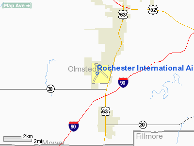
Rochester, Minnesota |
| Elevation AMSL |
1,317 ft / 401.4 m |
| Coordinates |
43°54′30″N 92°30′00″W / 43.90833°N 92.5°W / 43.90833; -92.5 |
| Website |
www.rochesterintlairport.com |
| Runways |
| Direction |
Length |
Surface |
| ft |
m |
| 13/31 |
9,033 |
2,753 |
Concrete |
| 2/20 |
7,300 |
2,225 |
Concrete |
| Statistics (2007) |
| Number of Passengers |
320,000 |
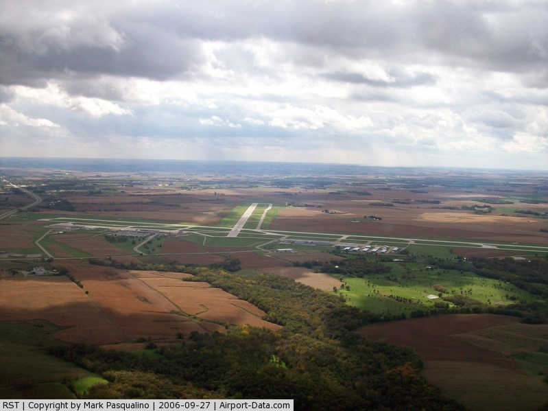
Rochester International Airport (IATA: RST, ICAO: KRST) is a nonhub primary airport located seven miles (11 km) southwest of the central business district of Rochester, a city in Olmsted County, Minnesota, United States.
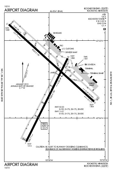
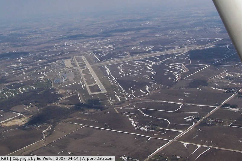
The airport covers 2,400 acres (971 ha) and has two runways: a 9,033 x 150 ft (2,743 x 46 m) concrete primary runway (13-31) and a 7,300 x 150 ft (2,225 x 46 m) concrete secondary runway (02-20).
Commercial air service is provided by American Airlines and Delta Air Lines. The airport also has a large FedEx Express terminal built recently, a small ABX Air station, as well as a general aviation terminal.
Due to an error on Google Maps, this airport is often called Rochester Municipal Airport by flight booking and airport information sites. History
The original Rochester International Airport was founded in 1928 by the Mayo Foundation as a way to get patients from far-flung locations to the Mayo Clinic. It originally was located in what is now southeast Rochester and occupied 285 acres (1.2 km²). The following year, 'Rochester Airport' was officially dedicated, and the Rochester Airport Company was founded as a subsidiary of the Mayo Foundation. Northwest Airlines began running Ford Trimotors to Rochester from its hub in St. Paul. Rochester was one of the first destinations from the Twin Cities in Northwest Airlines history, behind Chicago, Winnipeg, Green Bay, and Fargo. In 1940, the existing runways were paved, and additional land was acquired, bringing the airport's total area to 370 acres (1.5 km²). During World War II, the Army Air Corps conducted training operations from the airport. In 1945, the Mayo Foundation gave the airport to the city of Rochester, but the Rochester Airport Company continued to operate the field under an agreement with the city. The airport was renamed Lobb Field in 1952. In the 1940s through the 1960s, the airport was served by Braniff Airways, North Central Airlines, Ozark Airlines, and other small air carriers in addition to Northwest.
In 1960 it was decided to replace Lobb Field with a new airport southwest of the town because it could not be expanded to accommodate the larger airliners & was too close to the urban area of Rochester. The original Rochester Airport was closed in 1961.
In 1960, Rochester International Airport opened at its current location 8 miles (13 km) south of downtown Rochester. American Airlines began service to Chicago O'Hare in 1991. 1995 saw the addition of a US Customs post and it became the Rochester International Airport. TWA operated flights to St. Louis in early 2001, but these routes were dropped very soon due to the merger with American Airlines. On September 15, 2005, the primary runway was lengthened from 7,533' to 9,033' following a three-month closure for renovations. At the same time, runway centerline and touchdown zone lighting were both added. The change was made primarily to accommodate Saudi Arabian Airlines' 747's, which were heavily weight-restricted upon departure prior to the extension.
Future
- Sometime in 2013, an Instrument Landing System is slated to be added to runway 2/20. This would make all runways at the airport able to handle landings in almost any weather.
- Sometime before 2011, another jetway is slated to be added to the terminal, bringing the number of boarding bridge gates to 5.
- A long-term prediction for Rochester International outlines plans for a new runway and terminal. A new runway, 13R/31L, parallel to the airport's primary runway, is planned on being created about 2500' southwest of the primary runway. A new midfield terminal would be built between the two runways and just east of runway 2/20.
Airlines and destinations
| Airlines |
Destinations |
| American Eagle |
Chicago-O'Hare |
| Delta Connection operated by Mesaba Airlines |
Detroit, Minneapolis/St. Paul |
| Delta Connection operated by Pinnacle Airlines |
Detroit, Minneapolis/St. Paul |
| Delta Connection operated by Skywest Airlines |
Minneapolis/St. Paul |
| Sun Country Airlines |
Laughlin/Bullhead City [charter] |
Flights to Las Vegas were offered by Allegiant Air from June 14, 2007 until February 15, 2010.
Cargo Destinations
| Airlines |
Destinations |
| AirNet Express |
Minneapolis/St. Paul, Des Moines |
| FedEx Express |
Memphis |
| FedEx Feeder operated by CSA Air |
Brainerd, Duluth, Wausau |
| Freight Runners Express |
Milwaukee |
General Aviation Facilities
Rochester Aviation is the general aviation terminal at the airport. It is owned and operated by Hiawatha Aviation, Inc. The terminal provides line services, refueling services, and caters largely towards business aviation. RARE Aircraft, Ltd. provided flight instruction and aircraft rental up through August, 2006. On April 1, 2006, the ownership of Rochester Aviation was passed onto Regent Aviation of St. Paul. In November 2007, Regent Aviation in turn sold its ownership stake in Rochester's general aviation terminal to Signature Flight Support, a worldwide fixed base operator provider. Also as of November 2007, aircraft rental and flight instruction at RST was available through Legacy Aviation, operating two Cessna 172 aircraft with a group of Certified Flight Instructors. Legacy, however, folded in late 2009 and Rochester once again lacks a publicly-accessible flight training solution. The airport is also home to the Southeastern Minnesota Flying Club, which has had a presence at both RST and its predecessor Lobb Field for over 50 years.
The above content comes from Wikipedia and is published under free licenses – click here to read more.
|
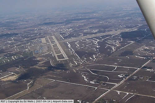 |
(Click on the photo to enlarge) |
|
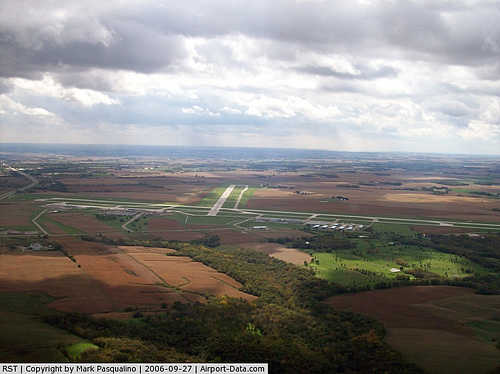 |
(Click on the photo to enlarge) |
Location & QuickFacts
| FAA Information Effective: | 2008-09-25 |
| Airport Identifier: | RST |
| Airport Status: | Operational |
| Longitude/Latitude: | 092-30-00.1000W/43-54-29.8000N
-92.500028/43.908278 (Estimated) |
| Elevation: | 1317 ft / 401.42 m (Surveyed) |
| Land: | 2400 acres |
| From nearest city: | 7 nautical miles SW of Rochester, MN |
| Location: | Olmsted County, MN |
| Magnetic Variation: | 01E (2005) |
Owner & Manager
| Ownership: | Publicly owned |
| Owner: | City Of Rochester |
| Address: | City Hall
Rochester, MN 55904 |
| Phone number: | 507-282-2328 |
| Manager: | Steven W Leqve |
| Address: | Helgerson Dr. Sw
Rochester, MN 55902 |
| Phone number: | 507-282-2328 |
Airport Operations and Facilities
| Airport Use: | Open to public |
| Wind indicator: | Yes |
| Segmented Circle: | No |
| Control Tower: | Yes |
| Lighting Schedule: | DUSK-DAWN
WHEN ATCT CLSD HIRL RY 13/31 PRESET; TO INCR INTSTY & ACTVT MIRL RY 02/20 & MALSR RY 13/31 - CTAF. |
| Beacon Color: | Clear-Green (lighted land airport) |
| Landing fee charge: | No |
| Sectional chart: | Chicago |
| Region: | AGL - Great Lakes |
| Boundary ARTCC: | ZMP - Minneapolis |
| Tie-in FSS: | PNM - Princeton |
| FSS on Airport: | No |
| FSS Toll Free: | 1-800-WX-BRIEF |
| NOTAMs Facility: | RST (NOTAM-d service avaliable) |
| Certification type/date: | I B S 05/1973
24 HR PPR FOR UNSKED ACR OPNS WITH MORE THAN 30 PSGR SEATS BTN 2300-0500; CALL 507-254-1161. |
| Federal Agreements: | NGY |
Airport Communications
| CTAF: | 118.300 |
| Unicom: | 122.950 |
Airport Services
| Fuel available: | 100LLA |
| Airframe Repair: | MAJOR |
| Power Plant Repair: | MAJOR |
| Bottled Oxygen: | HIGH/LOW |
| Bulk Oxygen: | NONE |
Runway Information
Runway 02/20
| Dimension: | 7300 x 150 ft / 2225.0 x 45.7 m |
| Surface: | CONC, Good Condition |
| Surface Treatment: | Wire Comb or Wire Tine |
| Weight Limit: | Single wheel: 100000 lbs.
Dual wheel: 175000 lbs.
Dual tandem wheel: 300000 lbs. |
| Edge Lights: | Medium |
| |
Runway 02 |
Runway 20 |
| Longitude: | 092-30-24.9349W | 092-29-40.4868W |
| Latitude: | 43-53-41.7425N | 43-54-46.2818N |
| Elevation: | 1315.00 ft | 1282.00 ft |
| Alignment: | 26 | 127 |
| Traffic Pattern: | Left | Left |
| Markings: | Non-precision instrument, Good Condition | Non-precision instrument, Good Condition |
| Crossing Height: | 47.00 ft | 57.00 ft |
| VASI: | 4-box on left side | 4-box on left side |
| Visual Glide Angle: | 3.00° | 3.00° |
| Runway End Identifier: | Yes | Yes |
|
Runway 13/31
| Dimension: | 9033 x 150 ft / 2753.3 x 45.7 m |
| Surface: | CONC, Good Condition |
| Surface Treatment: | Saw-cut or plastic Grooved |
| Weight Limit: | Single wheel: 100000 lbs.
Dual wheel: 175000 lbs.
Dual tandem wheel: 300000 lbs. |
| Edge Lights: | High |
| |
Runway 13 |
Runway 31 |
| Longitude: | 092-30-43.6608W | 092-29-12.1603W |
| Latitude: | 43-55-12.5414N | 43-54-12.7027N |
| Elevation: | 1268.00 ft | 1304.00 ft |
| Alignment: | 127 | 127 |
| ILS Type: | ILS
| ILS
|
| Traffic Pattern: | Left | Left |
| Markings: | Precision instrument, Good Condition | Precision instrument, Good Condition |
| Crossing Height: | 55.00 ft | 51.00 ft |
| VASI: | 4-box on left side | 4-light PAPI on left side |
| Visual Glide Angle: | 3.00° | 3.00° |
| RVR Equipment: | touchdown | touchdown
RY 13/31 RVR AVBL DURG ATCT HRS OF OPN ONLY. |
| Approach lights: | MALSR | MALSR |
| Centerline Lights: | Yes | Yes |
| Touchdown Lights: | Yes | Yes |
|
Radio Navigation Aids
| ID |
Type |
Name |
Ch |
Freq |
Var |
Dist |
| CJJ | NDB | Cresco | | 293.00 | 02E | 36.3 nm |
| ACQ | NDB | Waseca | | 371.00 | 02E | 46.5 nm |
| IY | NDB | Chukk | | 417.00 | 03E | 47.6 nm |
| CHU | NDB | Caledonia | | 209.00 | 03E | 47.9 nm |
| RST | VOR/DME | Rochester | 057X | 112.00 | 05E | 8.6 nm |
| JAY | VOR/DME | Austin | 019X | 108.20 | 03E | 27.0 nm |
| ONA | VOR/DME | Winona | 051X | 111.40 | 01E | 35.8 nm |
| AEL | VOR/DME | Albert Lea | 035X | 109.80 | 05E | 40.2 nm |
| FOW | VOR/DME | Halfway | 049X | 111.20 | 02E | 41.6 nm |
| ODI | VORTAC | Nodine | 126X | 117.90 | 01E | 44.7 nm |
Remarks
- WHEN ATCT CLSD SNOW REMOVAL EQUIPMENT OPERATORS MONITOR CTAF.
- WATERFOWL ON & INVOF ARPT.
- US CUSTOMS AVBL MON-FRI 0830-1700; AFTER HRS & WEEKENDS REQ PRIOR NOTIFICATION; CALL 507-285-5278.
Images and information placed above are from
http://www.airport-data.com/airport/RST/
We thank them for the data!
| General Info
|
| Country |
United States
|
| State |
MINNESOTA
|
| FAA ID |
RST
|
| Latitude |
43-54-25.996N
|
| Longitude |
092-29-56.409W
|
| Elevation |
1317 feet
|
| Near City |
ROCHESTER
|
We don't guarantee the information is fresh and accurate. The data may
be wrong or outdated.
For more up-to-date information please refer to other sources.
|
|