 |
|
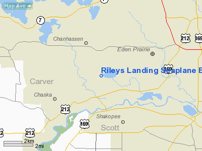
Rileys Landing Seaplane Base |
Location & QuickFacts
| FAA Information Effective: | 2008-09-25 |
| Airport Identifier: | MN21 |
| Airport Status: | Operational |
| Longitude/Latitude: | 093-32-00.8360W/44-49-59.8660N
-93.533566/44.833296 (Estimated) |
| Elevation: | 860 ft / 262.13 m (Estimated) |
| Land: | 0 acres |
| From nearest city: | 2 nautical miles S of Chanhassen Village, MN |
| Location: | Carver County, MN |
| Magnetic Variation: | 03E (1985) |
Owner & Manager
| Ownership: | Privately owned |
| Owner: | Anders J. Christenson |
| Address: | 11313 A. Ewing Circle
Bloomington, MN 55431 |
| Phone number: | 612-881-9614 |
| Address: |
|
Airport Operations and Facilities
| Airport Use: | Private |
| Wind indicator: | No |
| Segmented Circle: | No |
| Control Tower: | No |
| Landing fee charge: | No |
| Sectional chart: | Twin Cities |
| Region: | AGL - Great Lakes |
| Boundary ARTCC: | ZMP - Minneapolis |
| Tie-in FSS: | PNM - Princeton |
| FSS on Airport: | No |
| FSS Toll Free: | 1-800-WX-BRIEF |
Airport Services
| Airframe Repair: | NONE |
| Power Plant Repair: | NONE |
Runway Information
Runway 07/25
| Dimension: | 5000 x 3000 ft / 1524.0 x 914.4 m |
| Surface: | WATER, |
| |
Runway 07 |
Runway 25 |
| Traffic Pattern: | Left | Left |
|
Runway 13/31
| Dimension: | 5300 x 4000 ft / 1615.4 x 1219.2 m |
| Surface: | WATER, |
| |
Runway 13 |
Runway 31 |
| Traffic Pattern: | Left | Left |
|
Radio Navigation Aids
| ID |
Type |
Name |
Ch |
Freq |
Var |
Dist |
| MS | NDB | Narco | | 266.00 | 02E | 18.9 nm |
| GYL | NDB | Glencoe | | 407.00 | 03E | 24.0 nm |
| PPI | NDB | Hopey | | 400.00 | 03E | 25.3 nm |
| HCD | NDB | Hutchinson | | 209.00 | 04E | 36.2 nm |
| PNM | NDB | Princeton | | 368.00 | 03E | 44.1 nm |
| CBG | NDB | Cambridge | | 350.00 | 03E | 45.0 nm |
| ACQ | NDB | Waseca | | 371.00 | 02E | 45.9 nm |
| OEO | NDB | Osceola | | 233.00 | 01E | 45.9 nm |
| RNH | NDB | New Richmond | | 257.00 | 02E | 46.5 nm |
| FCM | VOR/DME | Flying Cloud | 055X | 111.80 | 06E | 3.3 nm |
| MSP | VOR/DME | Minneapolis | 100X | 115.30 | 02E | 13.2 nm |
| FOW | VOR/DME | Halfway | 049X | 111.20 | 02E | 38.4 nm |
| MKT | VOR/DME | Mankato | 045X | 110.80 | 07E | 40.3 nm |
| STC | VOR/DME | St Cloud | 058X | 112.10 | 03E | 48.4 nm |
| FGT | VORTAC | Farmington | 104X | 115.70 | 06E | 19.3 nm |
| GEP | VORTAC | Gopher | 120X | 117.30 | 06E | 20.0 nm |
| DWN | VORTAC | Darwin | 027X | 109.00 | 07E | 42.0 nm |
| MSP | VOT | Minneapolis St Paul | | 111.00 | | 13.9 nm |
| STP | VOT | St Paul | | 114.40 | | 21.2 nm |
Remarks
- BASE USED FOR ONE SEAPLANE ONLY-IT IS FLOWN BY SEVERAL OWNERS.
Images and information placed above are from
http://www.airport-data.com/airport/MN21/
We thank them for the data!
| General Info
|
| Country |
United States
|
| State |
MINNESOTA
|
| FAA ID |
MN21
|
| Latitude |
44-49-59.866N
|
| Longitude |
093-32-00.836W
|
| Elevation |
860 feet
|
| Near City |
CHANHASSEN VILLAGE
|
We don't guarantee the information is fresh and accurate. The data may
be wrong or outdated.
For more up-to-date information please refer to other sources.
|
|


