|
|
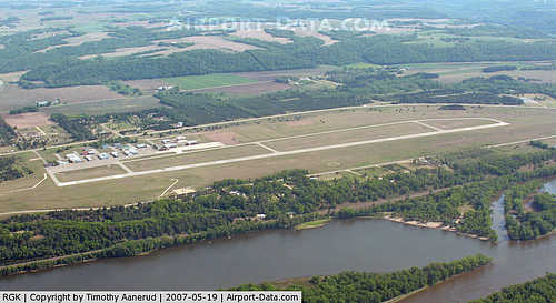
Red Wing Regional Airport |
| Red Wing Regional Airport |
| IATA: none – ICAO: KRGK – FAA LID: RGK |
| Summary |
| Airport type |
Public |
| Owner |
City of Red Wing |
| Serves |
Red Wing, Minnesota |
| Elevation AMSL |
780 ft / 238 m |
| Coordinates |
44°35′22″N 092°29′06″W / 44.58944°N 92.485°W / 44.58944; -92.485 |
| Website |
RedWingAirport.com |
| Runways |
| Direction |
Length |
Surface |
| ft |
m |
| 9/27 |
5,010 |
1,527 |
Asphalt |
| Statistics (2007) |
| Aircraft operations |
14,050 |
| Based aircraft |
55 |
| Sources: Minnesota DOT, FAA |
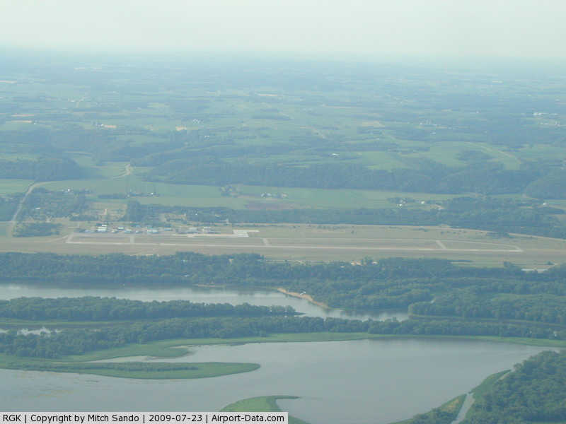
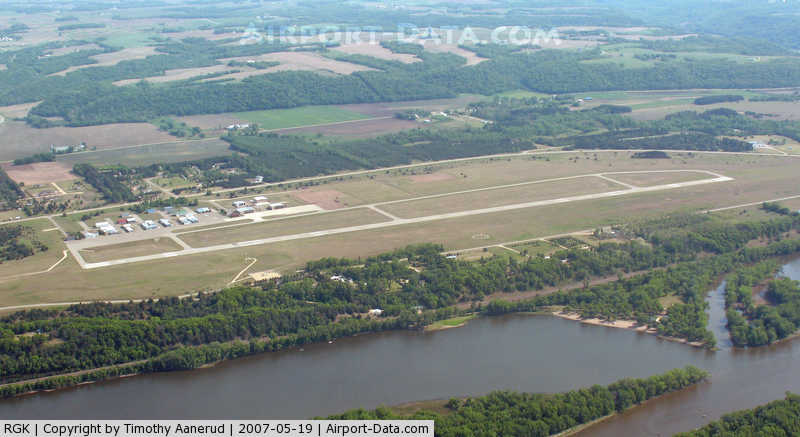
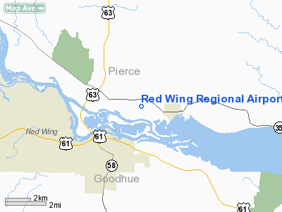
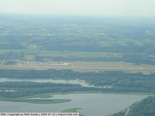
Red Wing Regional Airport (ICAO: KRGK, FAA LID: RGK) is a city-owned public-use airport located in Pierce County, Wisconsin, three nautical miles (6 km) northeast of the central business district of Red Wing, a city in Goodhue County, Minnesota, United States.
Although most U.S. airports use the same three-letter location identifier for the FAA and IATA, this airport is assigned RGK by the FAA but has no designation from the IATA.
Facilities and aircraft
Red Wing Regional Airport covers an area of 534 acres (216 ha) at an elevation of 780 feet (238 m) above mean sea level. It has one runway designated 9/27 with an asphalt surface measuring 5,010 by 100 feet (1,527 x 30 m).
For the 12-month period ending July 31, 2007, the airport had 14,050 aircraft operations, an average of 38 per day: 93 general aviation, 5% military and 2% air taxi. At that time there were 55 aircraft based at this airport: 85% single-engine, 2% jet, 4% helicopter, 4% glider and 5% ultralight.
The above content comes from Wikipedia and is published under free licenses – click here to read more.
|
 |
(Click on the photo to enlarge) |
|
 |
(Click on the photo to enlarge) |
Location & QuickFacts
| FAA Information Effective: | 2008-09-25 |
| Airport Identifier: | RGK |
| Airport Status: | Operational |
| Longitude/Latitude: | 092-29-05.8880W/44-35-21.6820N
-92.484969/44.589356 (Estimated) |
| Elevation: | 780 ft / 237.74 m (Surveyed) |
| Land: | 534 acres |
| From nearest city: | 3 nautical miles NE of Red Wing, MN |
| Location: | Pierce County, WI |
| Magnetic Variation: | 02E (1995) |
Owner & Manager
| Ownership: | Publicly owned |
| Owner: | City Of Red Wing |
| Address: | City Hall, 315 W 4th St
Red Wing, MN 55066 |
| Phone number: | 612-388-6734 |
| Manager: | Denny Tebbe |
| Address: | 229 Tyler Road North
Red Wing, MN 55066 |
| Phone number: | 651-385-3653 |
Airport Operations and Facilities
| Airport Use: | Open to public |
| Wind indicator: | Yes |
| Segmented Circle: | Yes |
| Control Tower: | No |
| Lighting Schedule: | DUSK-DAWN
ACTVT HIRL RY 09/27, MALSR RY 09, REIL RY 27, PAPI RYS 09 & 27 - CTAF. |
| Beacon Color: | Clear-Green (lighted land airport) |
| Landing fee charge: | No |
| Sectional chart: | Green Bay |
| Region: | AGL - Great Lakes |
| Boundary ARTCC: | ZMP - Minneapolis |
| Tie-in FSS: | GRB - Green Bay |
| FSS on Airport: | No |
| FSS Toll Free: | 1-800-WX-BRIEF |
| NOTAMs Facility: | RGK (NOTAM-d service avaliable) |
| Federal Agreements: | NGY |
Airport Communications
| CTAF: | 123.050 |
| Unicom: | 123.050 |
Airport Services
| Fuel available: | 100LLA
24 HR CREDIT CARD FUEL AVBL. |
| Airframe Repair: | MAJOR |
| Power Plant Repair: | MAJOR |
| Bottled Oxygen: | NONE |
| Bulk Oxygen: | NONE |
Runway Information
Runway 09/27
| Dimension: | 5010 x 100 ft / 1527.0 x 30.5 m |
| Surface: | ASPH, Good Condition |
| Weight Limit: | Single wheel: 30000 lbs.
Dual wheel: 75000 lbs. |
| Edge Lights: | High |
| |
Runway 09 |
Runway 27 |
| Longitude: | 092-29-40.4590W | 092-28-31.3210W |
| Latitude: | 44-35-22.9930N | 44-35-20.3640N |
| Elevation: | 778.00 ft | 777.00 ft |
| Alignment: | 93 | 127 |
| ILS Type: | ILS
| |
| Traffic Pattern: | Left | Left |
| Markings: | Precision instrument, Good Condition | Precision instrument, Good Condition |
| Crossing Height: | 35.00 ft | 30.00 ft |
| VASI: | 4-light PAPI on left side | 4-light PAPI on left side |
| Visual Glide Angle: | 3.00° | 3.16° |
| Approach lights: | MALSR | |
| Runway End Identifier: | No | Yes |
| Obstruction: | , 50:1 slope to clear | 58 ft trees, 1400.0 ft from runway, 200 ft right of centerline, 20:1 slope to clear |
|
Radio Navigation Aids
| ID |
Type |
Name |
Ch |
Freq |
Var |
Dist |
| PPI | NDB | Hopey | | 400.00 | 03E | 25.9 nm |
| MS | NDB | Narco | | 266.00 | 02E | 29.5 nm |
| RNH | NDB | New Richmond | | 257.00 | 02E | 33.6 nm |
| AHH | NDB | Ameron | | 278.00 | 01E | 41.9 nm |
| OEO | NDB | Osceola | | 233.00 | 01E | 44.2 nm |
| MSP | VOR/DME | Minneapolis | 100X | 115.30 | 02E | 37.0 nm |
| FCM | VOR/DME | Flying Cloud | 055X | 111.80 | 06E | 43.9 nm |
| FOW | VOR/DME | Halfway | 049X | 111.20 | 02E | 44.5 nm |
| ONA | VOR/DME | Winona | 051X | 111.40 | 01E | 45.5 nm |
| RST | VOR/DME | Rochester | 057X | 112.00 | 05E | 48.7 nm |
| FGT | VORTAC | Farmington | 104X | 115.70 | 06E | 29.9 nm |
| EAU | VORTAC | Eau Claire | 076X | 112.90 | 04E | 46.8 nm |
| STP | VOT | St Paul | | 114.40 | | 32.4 nm |
| MSP | VOT | Minneapolis St Paul | | 111.00 | | 35.9 nm |
Remarks
- ARPT ADMINISTRATION BLDG TELEPHONE 715-594-3041.
- RED WING RGNL IS PHYSICALLY LCTD IN WISCONSIN.
- CAUTION: DEER ON & INVOF AIRPORT.
- FOR NOISE ABATEMENT PROC CTC AMGR 651-385-3623.
Images and information placed above are from
http://www.airport-data.com/airport/RGK/
We thank them for the data!
| General Info
|
| Country |
United States
|
| State |
MINNESOTA
|
| FAA ID |
RGK
|
| Latitude |
44-35-21.682N
|
| Longitude |
092-29-05.888W
|
| Elevation |
780 feet
|
| Near City |
RED WING
|
We don't guarantee the information is fresh and accurate. The data may
be wrong or outdated.
For more up-to-date information please refer to other sources.
|
|