 |
|
Piney Pinecreek Border Airport |
Piney Pinecreek Border Airport
Piney/Pinecreek Border Airport |
| IATA: none – ICAO: none – FAA LID: 48Y – LID: CJX2 |
| Summary |
| Airport type |
Public |
| Owner |
Minnesota DOT |
| Operator |
Piney/Pinecreek Border Airport Commission |
| Serves |
Piney, Manitoba
Pinecreek, Minnesota |
| Location |
Canada-United States border |
| Elevation AMSL |
1,078 ft / 329 m |
| Coordinates |
48°59′58.6″N 095°58′57″W / 48.999611°N 95.9825°W / 48.999611; -95.9825 (Piney Pinecreek Border Airport)
49°00′00″N 095°58′57″W / 49°N 95.9825°W / 49; -95.9825 (Piney/Pinecreek Border Airport) |
| Runways |
| Direction |
Length |
Surface |
| ft |
m |
| 15/33 |
3,298
3,300 |
1,005
1,006 |
Asphalt |
| Statistics (2008) |
| Aircraft operations |
3,000 |
| Sources: Federal Aviation Administration and Canada Flight Supplement |
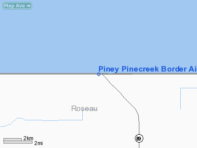
Piney Pinecreek Border Airport (FAA LID: 48Y, TC LID: 48Y) is a public use airport located 2 NM (3.7 km; 2.3 mi) northwest of the central business district of Pinecreek, in Roseau County, Minnesota, United States. It is owned by the Minnesota Department of Transportation.
Also known as Piney/Piney Pinecreek Border Airport, it is the first, and one of only three, "international airports" that cross the United States-Canada border (the others are Avey Field State Airport and Coronach/Scobey Border Station Airport). It is shared by the rural settlements of Piney, Manitoba and Pine Creek, Minnesota.
The airport, located at a latitude of 49 degrees, 0 minutes, 0 seconds latitude, 95 degrees, 58 minutes, 57 seconds longitude, originally was located entirely within the United States. Needing to extend the runway, the owners found it could not be extended south due to obstacles, but the land north was unused. After arrangements were made with Canadian and Manitoba authorities, the runway was extended across the 49th parallel.
The airport, located in both Manitoba and Minnesota (in Roseau County), has both United States and Canada customs services, and is attractive to tourists, hunters and fishermen. Ground access is available on Manitoba Highway 89 and Minnesota State Highway 89.
The airport is classified as an airport of entry by NAV CANADA and is staffed by the Canada Border Services Agency. CBSA officers at this airport currently can handle general aviation aircraft only, with no more than 15 passengers.
Facilities and aircraft
Piney Pinecreek Border Airport covers an area of 61 acres (25 ha) at an elevation of 1,078 ft (329 m) above mean sea level. It has one asphalt paved runway designated 15/33 which measures 3,298 by 75 ft (1,005 by 23 m). For the 12-month period ending May 31, 2008, the airport had 3,000 general aviation aircraft operations, an average of 250 per month.
The above content comes from Wikipedia and is published under free licenses – click here to read more.
Location & QuickFacts
| FAA Information Effective: | 2008-09-25 |
| Airport Identifier: | 48Y |
| Airport Status: | Operational |
| Longitude/Latitude: | 095-58-57.3000W/48-59-58.6000N
-95.982583/48.999611 (Estimated) |
| Elevation: | 1078 ft / 328.57 m (Surveyed) |
| Land: | 61 acres
ACREAGE: 60.5 ACRES IN U.S.; 7.7 ACRES IN CANADA. |
| From nearest city: | 2 nautical miles NW of Pinecreek, MN |
| Location: | Roseau County, MN |
| Magnetic Variation: | 05E (1995) |
Owner & Manager
| Ownership: | Publicly owned |
| Owner: | Minnesota Dot
JOINT OWNERSHIP: MN DOT & LCL GOVT DIST OF PINEY MANITOBA CANADA. |
| Address: | 222 Plato Blvd E.
St Paul, MN 55107 |
| Phone number: | 612-296-8202 |
| Manager: | Marlin Elton |
| Address: | 39495 - 310th Ave
Roseau, MN 56751 |
| Phone number: | 218-463-2030 |
Airport Operations and Facilities
| Airport Use: | Open to public |
| Wind indicator: | Yes |
| Segmented Circle: | Yes |
| Control Tower: | No |
| Lighting Schedule: | DUSK-DAWN
ACTVT MIRL RY 15/33 - CTAF. |
| Beacon Color: | Clear-Green (lighted land airport) |
| Landing fee charge: | No |
| Sectional chart: | Twin Cities |
| Region: | AGL - Great Lakes |
| Boundary ARTCC: | ZMP - Minneapolis |
| Tie-in FSS: | PNM - Princeton |
| FSS on Airport: | No |
| FSS Toll Free: | 1-800-WX-BRIEF |
| NOTAMs Facility: | PNM (NOTAM-d service avaliable) |
Airport Communications
| CTAF: | 122.800 |
| Unicom: | 122.800
UNICOM LCTD IN CUSTOMS OFC. |
Airport Services
| Fuel available: | 100LL
SELF SERVICE FUEL AVAIL 24 HRS. |
| Bulk Oxygen: | HIGH/LOW |
Runway Information
Runway 15/33
| Dimension: | 3298 x 75 ft / 1005.2 x 22.9 m |
| Surface: | ASPH, Good Condition |
| Edge Lights: | Medium |
| |
Runway 15 |
Runway 33 |
| Longitude: | 095-59-08.6000W | 095-58-46.0000W |
| Latitude: | 49-00-13.0400N | 48-59-44.1400N |
| Elevation: | 1078.00 ft | 1066.00 ft |
| Alignment: | 127 | 127 |
| Traffic Pattern: | Left | Left |
| Markings: | Non-precision instrument, Good Condition | Non-precision instrument, Good Condition |
| Runway End Identifier: | No | No |
| Centerline Lights: | No | No |
| Touchdown Lights: | No | No |
| Obstruction: | 75 ft trees, 3800.0 ft from runway, 48:1 slope to clear | 21 ft pole, 1040.0 ft from runway, 260 ft right of centerline, 40:1 slope to clear |
|
Radio Navigation Aids
| ID |
Type |
Name |
Ch |
Freq |
Var |
Dist |
| PFT | NDB | Piney Pinecreek | | 342.00 | 05E | 0.5 nm |
| ROX | VOR/DME | Roseau | 025X | 108.80 | 05E | 14.3 nm |
| HML | VORTAC | Humboldt | 071X | 112.40 | 09E | 45.5 nm |
Remarks
- CUSTOMS OFC ADJ TO ARPT; CUSTOMS PHONE 218-463-1952.
- NORTH PARKING RAMP IS IN CANADA; SOUTH PARKING RAMP IS IN U.S..
- CUSTOM HRS: 0900-1700 DLY.
- ARPT HAS TWO VALID IDENTS; CANADA USES 'JX2' & U.S. USES '48Y'.
Images and information placed above are from
http://www.airport-data.com/airport/48Y/
We thank them for the data!
| General Info
|
| Country |
United States
|
| State |
MINNESOTA
|
| FAA ID |
48Y
|
| Latitude |
48-59-58.600N
|
| Longitude |
095-58-57.300W
|
| Elevation |
1078 feet
|
| Near City |
PINECREEK
|
We don't guarantee the information is fresh and accurate. The data may
be wrong or outdated.
For more up-to-date information please refer to other sources.
|
|


