 |
|
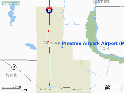
Location & QuickFacts
| FAA Information Effective: | 2008-09-25 |
| Airport Identifier: | MY28 |
| Airport Status: | Operational |
| Longitude/Latitude: | 092-57-47.3000W/45-34-47.2000N
-92.963139/45.579778 (Estimated) |
| Elevation: | 930 ft / 283.46 m (Estimated) |
| Land: | 180 acres |
| From nearest city: | 1 nautical miles E of Harris, MN |
| Location: | Chisago County, MN |
| Magnetic Variation: | () |
Owner & Manager
| Ownership: | Privately owned |
| Owner: | Marcus Shelander |
| Address: | 7255 Sunrise Rd
Harris, MN 55032 |
| Phone number: | 651-674-5567 |
| Manager: | Marcus Shelander |
| Address: | 7255 Sunrise Rd
Harris, MN 55032 |
| Phone number: | 651-674-5567 |
Airport Operations and Facilities
| Airport Use: | Private |
| Control Tower: | No |
| Sectional chart: | Green Bay |
| Region: | AGL - Great Lakes |
| Boundary ARTCC: | ZMP - Minneapolis |
| Tie-in FSS: | PNM - Princeton |
| FSS Toll Free: | 1-800-WX-BRIEF |
Airport Communications
Runway Information
Runway 16/34
| Dimension: | 2200 x 75 ft / 670.6 x 22.9 m |
| Surface: | TURF, |
| |
Runway 16 |
Runway 34 |
| Traffic Pattern: | Left | Left |
|
Radio Navigation Aids
| ID |
Type |
Name |
Ch |
Freq |
Var |
Dist |
| ROS | NDB | Rush City | | 282.00 | 02E | 7.0 nm |
| CBG | NDB | Cambridge | | 350.00 | 03E | 12.7 nm |
| OEO | NDB | Osceola | | 233.00 | 01E | 19.9 nm |
| JMR | NDB | Mora | | 327.00 | 03E | 22.6 nm |
| PNM | NDB | Princeton | | 368.00 | 03E | 27.1 nm |
| BXR | NDB | Big Doctor | | 203.00 | 02E | 29.0 nm |
| AHH | NDB | Ameron | | 278.00 | 01E | 30.7 nm |
| RNH | NDB | New Richmond | | 257.00 | 02E | 31.7 nm |
| UBE | NDB | Cumberland | | 375.00 | 01E | 41.7 nm |
| PPI | NDB | Hopey | | 400.00 | 03E | 42.5 nm |
| SSQ | NDB | Shell Lake | | 212.00 | 01E | 44.7 nm |
| MS | NDB | Narco | | 266.00 | 02E | 45.6 nm |
| RZN | VOR/DME | Siren | 031X | 109.40 | 02E | 28.6 nm |
| MSP | VOR/DME | Minneapolis | 100X | 115.30 | 02E | 42.7 nm |
| STC | VOR/DME | St Cloud | 058X | 112.10 | 03E | 46.1 nm |
| FCM | VOR/DME | Flying Cloud | 055X | 111.80 | 06E | 49.9 nm |
| GEP | VORTAC | Gopher | 120X | 117.30 | 06E | 31.3 nm |
| STP | VOT | St Paul | | 114.40 | | 38.6 nm |
| MSP | VOT | Minneapolis St Paul | | 111.00 | | 43.1 nm |
Remarks
- 400 FT RADIO TWR 1000 FT E; 200 FT RADIO TWR 1.5 NM SSW; 400 FT RADIO TWR 2.5 NM SSW; 100 FT WATER TANK 0,5 NM W & 40 FT POWER LINE 200 FT N OF RWY.
- PRVDD CLEAR 20:1 APCHS & CLEAR OBSTACLE FREE ZONE.
Images and information placed above are from
http://www.airport-data.com/airport/MY28/
We thank them for the data!
We don't guarantee the information is fresh and accurate. The data may
be wrong or outdated.
For more up-to-date information please refer to other sources.
|
|


