 |
|
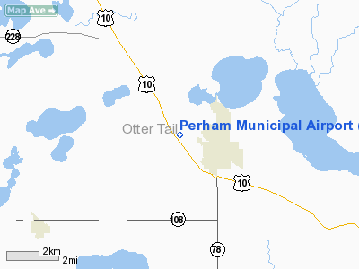
Location & QuickFacts
| FAA Information Effective: | 2008-09-25 |
| Airport Identifier: | 16D |
| Airport Status: | Operational |
| Longitude/Latitude: | 095-36-16.1520W/46-36-14.8540N
-95.604487/46.604126 (Estimated) |
| Elevation: | 1371 ft / 417.88 m (Surveyed) |
| Land: | 80 acres |
| From nearest city: | 2 nautical miles NW of Perham, MN |
| Location: | Otter Tail County, MN |
| Magnetic Variation: | 05E (1995) |
Owner & Manager
| Ownership: | Publicly owned |
| Owner: | City Of Perham |
| Address: | 125 2nd St Ne Box 130
Perham, MN 56573 |
| Phone number: | 218-346-4455 |
| Manager: | Bob Louiseau |
| Address: | 125 2nd St Ne Box 130
Perham, MN 56573 |
| Phone number: | 218-346-4455 |
Airport Operations and Facilities
| Airport Use: | Open to public |
| Wind indicator: | Yes |
| Segmented Circle: | No |
| Control Tower: | No |
| Lighting Schedule: | DUSK-DAWN
ACTVT MIRL RY 12/30; REIL AND PAPI RY 12; REIL AND PAPI RY 30 - CTAF. |
| Beacon Color: | Clear-Green (lighted land airport) |
| Landing fee charge: | No |
| Sectional chart: | Twin Cities |
| Region: | AGL - Great Lakes |
| Boundary ARTCC: | ZMP - Minneapolis |
| Tie-in FSS: | PNM - Princeton |
| FSS on Airport: | No |
| FSS Toll Free: | 1-800-WX-BRIEF |
| NOTAMs Facility: | PNM (NOTAM-d service avaliable) |
| Federal Agreements: | 1 |
Airport Communications
Airport Services
| Fuel available: | 100LL
FUEL AVAIL 24 HRS W CREDIT CARD. |
| Airframe Repair: | NONE |
| Power Plant Repair: | NONE |
| Bottled Oxygen: | NONE |
| Bulk Oxygen: | NONE |
Runway Information
Runway 12/30
| Dimension: | 4100 x 75 ft / 1249.7 x 22.9 m |
| Surface: | ASPH, Fair Condition
GRASS GROWING THROUGH CRACKS IN RY. |
| Edge Lights: | Medium |
| |
Runway 12 |
Runway 30 |
| Longitude: | 095-36-44.4000W | 095-35-59.6100W |
| Latitude: | 46-36-52.6500N | 46-36-26.4600N |
| Elevation: | 1376.00 ft | 1371.00 ft |
| Alignment: | 127 | 127 |
| Traffic Pattern: | Left | Left |
| Markings: | Non-precision instrument, Fair Condition | Non-precision instrument, Fair Condition |
| VASI: | 4-light PAPI on left side | 4-light PAPI on left side |
| Runway End Identifier: | Yes | Yes |
| Obstruction: | 16 ft pline, 870.0 ft from runway, 60 ft left of centerline, 41:1 slope to clear | 12 ft trees, 425.0 ft from runway, 200 ft left of centerline, 18:1 slope to clear |
|
Radio Navigation Aids
| ID |
Type |
Name |
Ch |
Freq |
Var |
Dist |
| PK | NDB | Spida | | 269.00 | 04E | 29.4 nm |
| SAZ | NDB | Staples | | 257.00 | 04E | 35.7 nm |
| BWP | NDB | Breckenridge-wahpeton | | 233.00 | 05E | 46.7 nm |
| DTL | VOR/DME | Detroit Lakes | 049X | 111.20 | 05E | 17.7 nm |
| PKD | VOR/DME | Park Rapids | 043X | 110.60 | 04E | 28.2 nm |
| FFM | VOR/DME | Fergus Falls | 041X | 110.40 | 05E | 29.7 nm |
| AXN | VOR/DME | Alexandria | 075X | 112.80 | 07E | 41.8 nm |
Remarks
- ULTRALIGHTS ON & INVOF ARPT.
Images and information placed above are from
http://www.airport-data.com/airport/16D/
We thank them for the data!
| General Info
|
| Country |
United States
|
| State |
MINNESOTA
|
| FAA ID |
16D
|
| Latitude |
46-36-14.854N
|
| Longitude |
095-36-16.152W
|
| Elevation |
1371 feet
|
| Near City |
PERHAM
|
We don't guarantee the information is fresh and accurate. The data may
be wrong or outdated.
For more up-to-date information please refer to other sources.
|
|


