 |
|
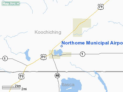
Northome Municipal Airport |
Location & QuickFacts
| FAA Information Effective: | 2008-09-25 |
| Airport Identifier: | 43Y |
| Airport Status: | Operational |
| Longitude/Latitude: | 094-15-31.3669W/47-53-17.1712N
-94.258713/47.888103 (Estimated) |
| Elevation: | 1427 ft / 434.95 m (Estimated) |
| Land: | 160 acres |
| From nearest city: | 2 nautical miles NE of Northome, MN |
| Location: | Koochiching County, MN |
| Magnetic Variation: | 04E (1985) |
Owner & Manager
| Ownership: | Publicly owned |
| Owner: | City Of Northome |
| Address: | Po Box 65, 12064 Main St.
Northome, MN 56661 |
| Phone number: | 218-897-5762 |
| Manager: | Karin Elhard |
| Address: | Po Box 65
Northome, MN 56661 |
| Phone number: | 218-897-5762 |
Airport Operations and Facilities
| Airport Use: | Open to public |
| Wind indicator: | Yes |
| Segmented Circle: | No |
| Control Tower: | No |
| Lighting Schedule: | DUSK-DAWN |
| Beacon Color: | Clear-Green (lighted land airport) |
| Landing fee charge: | No |
| Sectional chart: | Twin Cities |
| Region: | AGL - Great Lakes |
| Traffic Pattern Alt: | 1000 ft |
| Boundary ARTCC: | ZMP - Minneapolis |
| Tie-in FSS: | PNM - Princeton |
| FSS on Airport: | No |
| FSS Toll Free: | 1-800-WX-BRIEF |
| NOTAMs Facility: | PNM (NOTAM-d service avaliable) |
Airport Communications
Airport Services
Runway Information
Runway 02/20
| Dimension: | 2201 x 148 ft / 670.9 x 45.1 m
RWY 12/30: NW 2400 FEET USABLE. |
| Surface: | TURF, Good Condition
SE 800 FT SOFT AND UNEVEN. |
| |
Runway 02 |
Runway 20 |
| Longitude: | 094-15-44.8500W | 094-15-32.7600W |
| Latitude: | 47-53-09.7700N | 47-53-29.9100N |
| Elevation: | 1410.00 ft | 1420.00 ft |
| Traffic Pattern: | Left | Left |
| Displaced threshold: | 0.00 ft | 150.00 ft |
| Obstruction: | 50 ft trees, 1000.0 ft from runway, 100 ft right of centerline, 20:1 slope to clear | 63 ft trees, 780.0 ft from runway, 130 ft right of centerline, 12:1 slope to clear
RWY 20: 14:1 TO DSPLCH THLD. |
|
Runway 12/30
| Dimension: | 3199 x 147 ft / 975.1 x 44.8 m
RWY 12/30: NW 2400 FEET USABLE. |
| Surface: | TURF, Good Condition
SE 800 FT SOFT AND UNEVEN. |
| Edge Lights: | Non-standard lighting system
NSTD LIRL; VARIABLE SPACING. |
| |
Runway 12 |
Runway 30 |
| Longitude: | 094-15-45.6800W | 094-15-06.9200W |
| Latitude: | 47-53-24.2400N | 47-53-06.4300N |
| Elevation: | 1420.00 ft | 1427.00 ft |
| Traffic Pattern: | Left | Left |
| Obstruction: | 54 ft trees, 900.0 ft from runway, 80 ft left of centerline, 16:1 slope to clear | 60 ft trees, 800.0 ft from runway, 75 ft left of centerline, 13:1 slope to clear |
|
Radio Navigation Aids
| ID |
Type |
Name |
Ch |
Freq |
Var |
Dist |
| FOZ | NDB | Bigfork | | 345.00 | 02E | 25.2 nm |
| BJI | VORTAC | Bemidji | 023X | 108.60 | 04E | 36.2 nm |
Remarks
- RWY 02-20 CLSD WINTER MONTHS.
- PRVDD THRS ARE LCTD & CLRLY MKD TO PRVD A MIN 20:1 CLRNC OVER ALL OBSTNS.
Images and information placed above are from
http://www.airport-data.com/airport/43Y/
We thank them for the data!
| General Info
|
| Country |
United States
|
| State |
MINNESOTA
|
| FAA ID |
43Y
|
| Latitude |
47-53-29.842N
|
| Longitude |
094-15-00.802W
|
| Elevation |
1427 feet
|
| Near City |
NORTHOME
|
We don't guarantee the information is fresh and accurate. The data may
be wrong or outdated.
For more up-to-date information please refer to other sources.
|
|


