|
|
New Ulm Municipal Airport |
| New Ulm Municipal Airport |
| IATA: ULM – ICAO: KULM – FAA LID: ULM |
| Summary |
| Airport type |
Public |
| Operator |
City of New Ulm |
| Location |
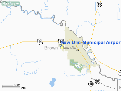
New Ulm, Minnesota |
| Elevation AMSL |
1,011 ft / 308.2 m |
| Coordinates |
44°19′10″N 094°30′08″W / 44.31944°N 94.50222°W / 44.31944; -94.50222Coordinates: 44°19′10″N 094°30′08″W / 44.31944°N 94.50222°W / 44.31944; -94.50222 |
| Runways |
| Direction |
Length |
Surface |
| ft |
m |
| 15/33 |
4,401 |
1,341 |
Asphalt |
| 4/22 |
2,825 |
861 |
Grass |
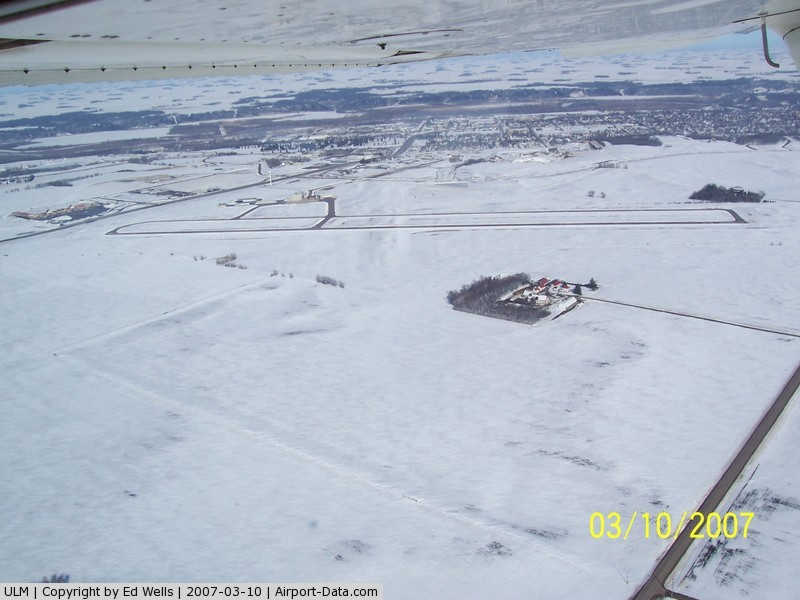
New Ulm Municipal Airport (IATA: ULM, ICAO: KULM, FAA LID: ULM) is a public airport located two statute miles (3 km) west of the central business district (CBD) of New Ulm, a city in Brown County, Minnesota, USA. This general aviation airport covers 195 acres (79 ha) and has two runways. Scheduled airline service was once available on Midwest Aviation, also known as Lake State Airways.
The above content comes from Wikipedia and is published under free licenses – click here to read more.
|
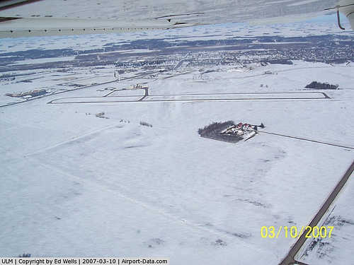 |
(Click on the photo to enlarge) |
Location & QuickFacts
| FAA Information Effective: | 2008-09-25 |
| Airport Identifier: | ULM |
| Airport Status: | Operational |
| Longitude/Latitude: | 094-30-08.4000W/44-19-11.1000N
-94.502333/44.319750 (Estimated) |
| Elevation: | 1011 ft / 308.15 m (Surveyed) |
| Land: | 195 acres |
| From nearest city: | 2 nautical miles W of New Ulm, MN |
| Location: | Brown County, MN |
| Magnetic Variation: | 04E (1995) |
Owner & Manager
| Ownership: | Publicly owned |
| Owner: | City Of New Ulm |
| Address: | 100 N Broadway, Box 636
New Ulm, MN 56073 |
| Phone number: | 507-359-8233 |
| Manager: | Pete Johnson |
| Address: | 1617 Highway 14 W
New Ulm, MN 56073 |
| Phone number: | 507-354-8127 |
Airport Operations and Facilities
| Airport Use: | Open to public |
| Wind indicator: | Yes |
| Segmented Circle: | No |
| Control Tower: | No |
| Lighting Schedule: | DUSK-DAWN
ACTVT MIRL RWY 15/33 REIL RYS 15 & 33 ODALS RWY 33 & PAPI RWYS 15/33 - 122.8. |
| Beacon Color: | Clear-Green (lighted land airport) |
| Landing fee charge: | No |
| Sectional chart: | Omaha |
| Region: | AGL - Great Lakes |
| Boundary ARTCC: | ZMP - Minneapolis |
| Tie-in FSS: | PNM - Princeton |
| FSS on Airport: | No |
| FSS Toll Free: | 1-800-WX-BRIEF |
| NOTAMs Facility: | ULM (NOTAM-d service avaliable) |
| Federal Agreements: | NGY |
Airport Communications
| CTAF: | 122.800 |
| Unicom: | 122.800 |
Airport Services
| Fuel available: | 100LLA |
| Airframe Repair: | MAJOR |
| Power Plant Repair: | MAJOR |
| Bottled Oxygen: | NONE |
| Bulk Oxygen: | NONE |
Runway Information
Runway 04/22
| Dimension: | 2826 x 160 ft / 861.4 x 48.8 m |
| Surface: | TURF, Good Condition |
| |
Runway 04 |
Runway 22 |
| Alignment: | 49 | 127 |
| Traffic Pattern: | Left | Left |
| Runway End Identifier: | No | No |
| Centerline Lights: | No | No |
| Touchdown Lights: | No | No |
| Obstruction: | 27 ft tree, 440.0 ft from runway, 100 ft left of centerline, 16:1 slope to clear | 15 ft road, 450.0 ft from runway, 170 ft left of centerline, 30:1 slope to clear |
|
Runway 15/33
| Dimension: | 4401 x 75 ft / 1341.4 x 22.9 m |
| Surface: | ASPH, Good Condition |
| Edge Lights: | Medium |
| |
Runway 15 |
Runway 33 |
| Longitude: | 094-30-24.6192W | 094-29-55.0635W |
| Latitude: | 44-19-28.5549N | 44-18-50.6343N |
| Elevation: | 1004.00 ft | 1009.00 ft |
| Alignment: | 127 | 127 |
| Traffic Pattern: | Left | Left |
| Markings: | Non-precision instrument, Good Condition | Non-precision instrument, Good Condition |
| Crossing Height: | 40.00 ft | 38.00 ft |
| VASI: | 4-light PAPI on left side | 4-light PAPI on right side |
| Visual Glide Angle: | 3.00° | 3.00° |
| Approach lights: | | ODALS |
| Runway End Identifier: | Yes | Yes |
| Obstruction: | 18 ft road, 890.0 ft from runway, 38:1 slope to clear | 11 ft road, 550.0 ft from runway, 250 ft left of centerline, 31:1 slope to clear
+8 FT HILL 100 FT FM RY END 190L. |
|
Radio Navigation Aids
| ID |
Type |
Name |
Ch |
Freq |
Var |
Dist |
| JYG | NDB | St James | | 260.00 | 04E | 20.2 nm |
| GYL | NDB | Glencoe | | 407.00 | 03E | 32.0 nm |
| HCD | NDB | Hutchinson | | 209.00 | 04E | 32.7 nm |
| MWM | NDB | Windom | | 203.00 | 03E | 36.0 nm |
| ACQ | NDB | Waseca | | 371.00 | 02E | 43.6 nm |
| MJQ | NDB | Jackson | | 353.00 | 04E | 45.5 nm |
| SBU | NDB | Blue Earth | | 332.00 | 04E | 46.8 nm |
| ULM | NDB/DME | New Ulm | 050X | 272.00 | 04E | 0.2 nm |
| MKT | VOR/DME | Mankato | 045X | 110.80 | 07E | 26.1 nm |
| RWF | VOR/DME | Redwood Falls | 080X | 113.30 | 07E | 28.3 nm |
| FRM | VOR/DME | Fairmont | 039X | 110.20 | 07E | 40.6 nm |
| FOW | VOR/DME | Halfway | 049X | 111.20 | 02E | 49.2 nm |
| DWN | VORTAC | Darwin | 027X | 109.00 | 07E | 46.2 nm |
Remarks
- TURF RWY 4/22 CLSD WINTER MONTHS.
- ULTRALIGHT TRAFFIC ON & INVOF ARPT.
- GCO AVBL ON FREQ 121.725 THRU MINNEAPOLIS ARTCC & FLT SVCS.
Images and information placed above are from
http://www.airport-data.com/airport/ULM/
We thank them for the data!
| General Info
|
| Country |
United States
|
| State |
MINNESOTA
|
| FAA ID |
ULM
|
| Latitude |
44-19-10.463N
|
| Longitude |
094-30-08.308W
|
| Elevation |
1011 feet
|
| Near City |
NEW ULM
|
We don't guarantee the information is fresh and accurate. The data may
be wrong or outdated.
For more up-to-date information please refer to other sources.
|
|