|
|
|
 |
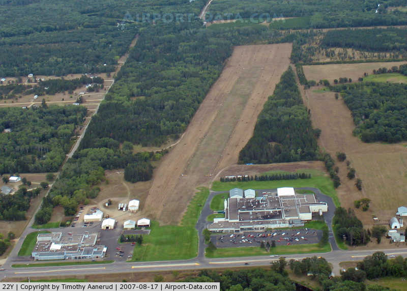
(Click on the photo to enlarge) |
Location & QuickFacts
| FAA Information Effective: | 2008-09-25 |
| Airport Identifier: | 22Y |
| Airport Status: | Operational |
| Longitude/Latitude: | 094-38-19.0490W/46-19-24.8730N
-94.638625/46.323576 (Estimated) |
| Elevation: | 1225 ft / 373.38 m (Estimated) |
| Land: | 30 acres |
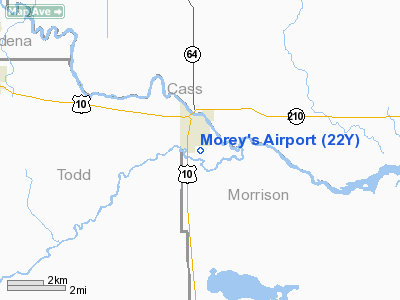
| From nearest city: | 1 nautical miles S of Motley, MN |
| Location: | Morrison County, MN |
| Magnetic Variation: | 04E (1995) |
Owner & Manager
| Ownership: | Privately owned |
| Owner: | Loren A. Morey |
| Address: | 38503 30th Ave
Motley, MN 56466 |
| Phone number: | 218-352-6467 |
| Manager: | Loren A. Morey |
| Address: | Box 248
Motley, MN 56466 |
| Phone number: | 218-352-2109 |
Airport Operations and Facilities
| Airport Use: | Open to public |
| Wind indicator: | Yes |
| Segmented Circle: | No |
| Control Tower: | No |
| Landing fee charge: | No |
| Sectional chart: | Twin Cities |
| Region: | AGL - Great Lakes |
| Boundary ARTCC: | ZMP - Minneapolis |
| Tie-in FSS: | PNM - Princeton |
| FSS on Airport: | No |
| FSS Toll Free: | 1-800-WX-BRIEF |
| NOTAMs Facility: | PNM (NOTAM-d service avaliable) |
Airport Communications
Airport Services
Runway Information
Runway 09/27
| Dimension: | 2720 x 150 ft / 829.1 x 45.7 m |
| Surface: | TURF, Fair Condition |
| |
Runway 09 |
Runway 27 |
| Longitude: | 094-38-38.5700W | 094-38-00.5200W |
| Latitude: | 46-19-27.9400N | 46-19-22.7900N |
| Elevation: | 1225.00 ft | 1225.00 ft |
| Alignment: | 101 | 127 |
| Traffic Pattern: | Left | Left |
| Runway End Identifier: | No | No |
| Centerline Lights: | No | No |
| Touchdown Lights: | No | No |
| Obstruction: | 35 ft trees, 1.0 ft from runway, 230 ft left of centerline | 30 ft trees, 1.0 ft from runway, 230 ft right of centerline |
|
Radio Navigation Aids
| ID |
Type |
Name |
Ch |
Freq |
Var |
Dist |
| SAZ | NDB | Staples | | 257.00 | 04E | 7.7 nm |
| XCR | NDB | Ripley | | 404.00 | 03E | 19.2 nm |
| LXL | NDB | Little Falls | | 359.00 | 03E | 25.6 nm |
| PWC | NDB | Pine River | | 330.00 | 03E | 26.4 nm |
| PK | NDB | Spida | | 269.00 | 04E | 33.7 nm |
| AIT | NDB | Aitkin | | 397.00 | 03E | 42.1 nm |
| EE | NDB | Tamie | | 374.00 | 04E | 42.4 nm |
| XVG | NDB | Longville | | 392.00 | 04E | 44.1 nm |
| GHW | NDB | Glenwood | | 346.00 | 03E | 49.7 nm |
| RYM | TACAN | Camp Ripley | 048X | | 03E | 18.3 nm |
| AXN | VOR/DME | Alexandria | 075X | 112.80 | 07E | 33.1 nm |
| PKD | VOR/DME | Park Rapids | 043X | 110.60 | 04E | 38.9 nm |
| BRD | VORTAC | Brainerd | 116X | 116.90 | 03E | 25.5 nm |
Remarks
- LGTD AND MKD 1533' MSL TOWER LCTD 1.3 NM WEST OF ARPT.
- ARPT CLSD WHEN SNOW COVERED; CONFIRM CONDITIONS WITH AMGR ON 218-352-6600.
Images and information placed above are from
http://www.airport-data.com/airport/22Y/
We thank them for the data!
| General Info
|
| Country |
United States
|
| State |
MINNESOTA
|
| FAA ID |
22Y
|
| Latitude |
46-19-24.873N
|
| Longitude |
094-38-19.049W
|
| Elevation |
1225 feet
|
| Near City |
MOTLEY
|
We don't guarantee the information is fresh and accurate. The data may
be wrong or outdated.
For more up-to-date information please refer to other sources.
|
|