 |
|
Location & QuickFacts
| FAA Information Effective: | 2008-09-25 |
| Airport Identifier: | 86MN |
| Airport Status: | Operational |
| Longitude/Latitude: | 092-30-20.6470W/44-04-19.8710N
-92.505735/44.072186 (Estimated) |
| Elevation: | 1024 ft / 312.12 m (Estimated) |
| Land: | 0 acres |
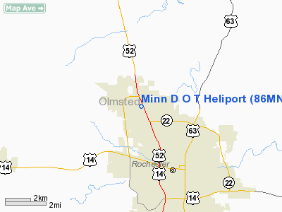
| From nearest city: | 1 nautical miles NW of Rochester, MN |
| Location: | Olmsted County, MN |
| Magnetic Variation: | 03E (1985) |
Owner & Manager
| Ownership: | Publicly owned |
| Owner: | Minn D O T |
| Address: | Box 6177
Rochester, MN 55903 |
| Phone number: | 507-285-7113 |
| Manager: | Lee Gierok |
| Address: | Box 6177
Rochester, MN 55903 |
| Phone number: | 507-285-7113 |
Airport Operations and Facilities
| Airport Use: | Private |
| Wind indicator: | Yes |
| Segmented Circle: | Yes |
| Control Tower: | No |
| Sectional chart: | Green Bay |
| Region: | AGL - Great Lakes |
| Boundary ARTCC: | ZMP - Minneapolis |
| Tie-in FSS: | PNM - Princeton |
| FSS on Airport: | No |
| FSS Toll Free: | 1-800-WX-BRIEF |
Runway Information
Helipad H1
| Dimension: | 100 x 100 ft / 30.5 x 30.5 m |
| Surface: | ASPH, |
| |
Runway H1 |
Runway |
| Traffic Pattern: | Left | Left |
|
Radio Navigation Aids
| ID |
Type |
Name |
Ch |
Freq |
Var |
Dist |
| ACQ | NDB | Waseca | | 371.00 | 02E | 45.2 nm |
| CJJ | NDB | Cresco | | 293.00 | 02E | 45.5 nm |
| RST | VOR/DME | Rochester | 057X | 112.00 | 05E | 17.8 nm |
| ONA | VOR/DME | Winona | 051X | 111.40 | 01E | 34.5 nm |
| JAY | VOR/DME | Austin | 019X | 108.20 | 03E | 34.8 nm |
| FOW | VOR/DME | Halfway | 049X | 111.20 | 02E | 38.1 nm |
| AEL | VOR/DME | Albert Lea | 035X | 109.80 | 05E | 44.2 nm |
| FGT | VORTAC | Farmington | 104X | 115.70 | 06E | 44.4 nm |
| ODI | VORTAC | Nodine | 126X | 117.90 | 01E | 45.9 nm |
Remarks
- (E111-2) E111: NO NIGHT HEL OPNS CONDUCTED UNLESS TKOF/LDG AREA & WDI ARE LGTD & A HEL ID BCN IS INSTLD.
- (E111-3) E111: UNAUTHORIZED PERSONS & VEHICLES RESTRICTED FROM TKOF/LDG AREA DURING HEL FLT OPNS BY A NON-OBSTRUCTING SAFETY BARRIER 51' FROM CNTR OF LDG AREA.
- E111: ALL APCH/DEP HEL OPNS CONDUCTED FROM 360 DEG CLKWS TO 030 DEG & FROM 145 DEG CLKWS TO 295 DEG USING TCHDWN PAD AS CNTR OF COMPASS ROSE. E111: THE TKOF/LDG AREA IS APPROPRIATELY MKD. A NON-OBSTRUCTING WDI IS MAINTAINED ADJT TO THE TKOF/LDG AREA.
Images and information placed above are from
http://www.airport-data.com/airport/86MN/
We thank them for the data!
| General Info
|
| Country |
United States
|
| State |
MINNESOTA
|
| FAA ID |
86MN
|
| Latitude |
44-04-19.871N
|
| Longitude |
092-30-20.647W
|
| Elevation |
1024 feet
|
| Near City |
ROCHESTER
|
We don't guarantee the information is fresh and accurate. The data may
be wrong or outdated.
For more up-to-date information please refer to other sources.
|
|


