 |
|
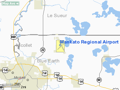
| Mankato Regional Airport |
| IATA: MKT – ICAO: KMKT – FAA LID: MKT |
| Summary |
| Airport type |
Public |
| Owner |
City of Mankato |
| Location |
Mankato, Minnesota |
| Elevation AMSL |
1,020 ft / 311 m |
| Coordinates |
44°13′18″N 093°55′07″W / 44.22167°N 93.91861°W / 44.22167; -93.91861 |
| Runways |
| Direction |
Length |
Surface |
| ft |
m |
| 4/22 |
3,999 |
1,219 |
Asphalt |
| 15/33 |
6,600 |
2,012 |
Concrete |
| Statistics (2002) |
| Aircraft operations |
85,500 |
| Based aircraft |
71 |
| Source: Federal Aviation Administration |
Mankato Regional Airport (IATA: MKT, ICAO: KMKT, FAA LID: MKT) is a public airport located five miles (8 km) northeast of the central business district of Mankato, a city in Blue Earth County, Minnesota, United States. This airport is publicly owned by City of Mankato. The airport is home to Northstar Aviation (FBO) and Minnesota State University's flight training program.
Facilities and aircraft
Mankato Regional Airport covers an area of 900 acres (364 ha) which contains two runways:
- Runway 4/22: 3,999 x 75 ft (1,219 x 23 m), Surface: Asphalt
- Runway 15/33: 6,600 x 100 ft (2,012 x 30 m), Surface: Concrete (Expanded from 5,400 feet (1,600 m) in 2007)
For 12-month period ending 30 April 2002 the airport had 85,500 aircraft operations, an average of 234 per day: 97% general aviation (83,000), 2% air taxi (2,000) and 1% military (500). There are 71 aircraft based at this airport: 82% single engine (58), 10% multi engine (7), 4% ultralights (3), 3% jet aircraft (2) and 1% helicopters (1).
The above content comes from Wikipedia and is published under free licenses – click here to read more.
Location & QuickFacts
| FAA Information Effective: | 2008-09-25 |
| Airport Identifier: | MKT |
| Airport Status: | Operational |
| Longitude/Latitude: | 093-55-09.4624W/44-13-22.0024N
-93.919295/44.222778 (Estimated) |
| Elevation: | 1021 ft / 311.20 m (Surveyed) |
| Land: | 900 acres |
| From nearest city: | 5 nautical miles NE of Mankato, MN |
| Location: | Blue Earth County, MN |
| Magnetic Variation: | 04E (1985) |
Owner & Manager
| Ownership: | Publicly owned |
| Owner: | City Of Mankato |
| Address: | 10 Civic Center Plaza, P.o. Box 3368
Mankato, MN 56001 |
| Phone number: | 507-387-8600 |
| Manager: | Kevin Baker |
| Address: | 3030 Airport Road
Mankato, MN 56001 |
| Phone number: | 507-345-3171 |
Airport Operations and Facilities
| Airport Use: | Open to public |
| Wind indicator: | Yes |
| Segmented Circle: | Yes |
| Control Tower: | No |
| Lighting Schedule: | DUSK-DAWN
ACTVT MIRL RY 04/22, HIRL RY 15/33, VASI RYS 04 & 22, PAPI RYS 15 & 33, REIL RYS 04, 15, & 22, & MALSR RY 33 - CTAF. |
| Beacon Color: | Clear-Green (lighted land airport) |
| Landing fee charge: | No |
| Sectional chart: | Omaha |
| Region: | AGL - Great Lakes |
| Boundary ARTCC: | ZMP - Minneapolis |
| Tie-in FSS: | PNM - Princeton |
| FSS on Airport: | No |
| FSS Toll Free: | 1-800-WX-BRIEF |
| NOTAMs Facility: | MKT (NOTAM-d service avaliable) |
| Federal Agreements: | NGY |
Airport Communications
| CTAF: | 122.725 |
| Unicom: | 122.725 |
Airport Services
| Fuel available: | 100LLA |
| Airframe Repair: | MAJOR |
| Power Plant Repair: | MAJOR |
| Bottled Oxygen: | LOW |
| Bulk Oxygen: | NONE |
Runway Information
Runway 04/22
| Dimension: | 3999 x 75 ft / 1218.9 x 22.9 m |
| Surface: | ASPH, Good Condition |
| Surface Treatment: | Saw-cut or plastic Grooved |
| Weight Limit: | Single wheel: 18000 lbs.
Dual wheel: 25000 lbs. |
| Edge Lights: | Medium |
| |
Runway 04 |
Runway 22 |
| Longitude: | 093-55-29.9320W | 093-54-49.5580W |
| Latitude: | 44-12-55.3020N | 44-13-22.0670N |
| Elevation: | 1007.00 ft | 1019.00 ft |
| Alignment: | 47 | 127 |
| Traffic Pattern: | Left | Left |
| Markings: | Non-precision instrument, Good Condition | Non-precision instrument, Good Condition |
| Crossing Height: | 39.00 ft | 26.00 ft |
| VASI: | 2-box on left side | 2-box on left side |
| Visual Glide Angle: | 3.00° | 3.00° |
| Runway End Identifier: | Yes | Yes |
| Obstruction: | 41 ft tree, 1480.0 ft from runway, 235 ft right of centerline, 31:1 slope to clear | 81 ft trees, 2000.0 ft from runway, 22:1 slope to clear |
|
Runway 15/33
| Dimension: | 6600 x 100 ft / 2011.7 x 30.5 m |
| Surface: | CONC, Good Condition |
| Surface Treatment: | Saw-cut or plastic Grooved |
| Weight Limit: | Single wheel: 40000 lbs.
Dual wheel: 60000 lbs.
Dual tandem wheel: 100000 lbs. |
| Edge Lights: | High |
| |
Runway 15 |
Runway 33 |
| Longitude: | 093-55-28.7729W | 093-54-49.8458W |
| Latitude: | 44-13-59.5148N | 44-13-00.6593N |
| Elevation: | 1019.00 ft | 1021.00 ft |
| Alignment: | 127 | 127 |
| ILS Type: | | ILS
|
| Traffic Pattern: | Left | Left |
| Markings: | Precision instrument, Good Condition | Precision instrument, Good Condition |
| Crossing Height: | 48.00 ft | 48.00 ft |
| VASI: | 4-light PAPI on right side | 4-light PAPI on right side |
| Visual Glide Angle: | 3.00° | 3.00° |
| Approach lights: | | MALSR |
| Runway End Identifier: | Yes | |
|
Radio Navigation Aids
| ID |
Type |
Name |
Ch |
Freq |
Var |
Dist |
| ACQ | NDB | Waseca | | 371.00 | 02E | 18.3 nm |
| JYG | NDB | St James | | 260.00 | 04E | 30.8 nm |
| GYL | NDB | Glencoe | | 407.00 | 03E | 33.1 nm |
| SBU | NDB | Blue Earth | | 332.00 | 04E | 38.4 nm |
| HCD | NDB | Hutchinson | | 209.00 | 04E | 43.0 nm |
| ULM | NDB/DME | New Ulm | 050X | 272.00 | 04E | 25.6 nm |
| MKT | VOR/DME | Mankato | 045X | 110.80 | 07E | 0.3 nm |
| FOW | VOR/DME | Halfway | 049X | 111.20 | 02E | 23.7 nm |
| AEL | VOR/DME | Albert Lea | 035X | 109.80 | 05E | 40.3 nm |
| FRM | VOR/DME | Fairmont | 039X | 110.20 | 07E | 40.9 nm |
| FCM | VOR/DME | Flying Cloud | 055X | 111.80 | 06E | 41.3 nm |
| MSP | VOR/DME | Minneapolis | 100X | 115.30 | 02E | 49.9 nm |
| FGT | VORTAC | Farmington | 104X | 115.70 | 06E | 40.0 nm |
| MSP | VOT | Minneapolis St Paul | | 111.00 | | 49.9 nm |
Remarks
- DEER ON & INVOF ARPT.
- MIGRATORY WATERFOWL ON & INVOF ARPT.
Images and information placed above are from
http://www.airport-data.com/airport/MKT/
We thank them for the data!
| General Info
|
| Country |
United States
|
| State |
MINNESOTA
|
| FAA ID |
MKT
|
| Latitude |
44-13-17.923N
|
| Longitude |
093-55-07.476W
|
| Elevation |
1020 feet
|
| Near City |
MANKATO
|
We don't guarantee the information is fresh and accurate. The data may
be wrong or outdated.
For more up-to-date information please refer to other sources.
|
|


