|
|
Little Falls / Morrison County - Lindbergh Fld Airport |
Little Falls/Morrison County Airport
Lindbergh Field |
| IATA: none – ICAO: KLXL – FAA LID: LXL |
| Summary |
| Airport type |
Public |
| Owner |
City of Little Falls & Morrison County |
| Serves |
Little Falls, Minnesota |
| Elevation AMSL |
1,122 ft / 342 m |
| Coordinates |
45°56′59″N 094°20′51″W / 45.94972°N 94.3475°W / 45.94972; -94.3475 |
| Runways |
| Direction |
Length |
Surface |
| ft |
m |
| 13/31 |
4,000 |
1,219 |
Asphalt |
| 18/36 |
2,890 |
881 |
Turf |
| Statistics (2006) |
| Aircraft operations |
22,450 |
| Based aircraft |
43 |
| Source: Federal Aviation Administration |
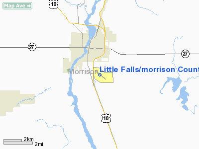
Little Falls/Morrison County Airport (ICAO: KLXL, FAA LID: LXL), also known as Lindbergh Field, is a public airport located two miles (3 km) south of the central business district of Little Falls, a city in Morrison County, Minnesota, United States. It is owned by the City of Little Falls and Morrison County.
Although most U.S. airports use the same three-letter location identifier for the FAA and IATA, Little Falls/Morrison County Airport is assigned LXL by the FAA but has no designation from the IATA.
Facilities and aircraft
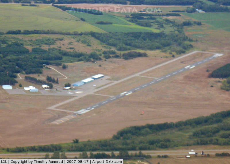
Little Falls/Morrison County Airport covers an area of 290 acres (117 ha) which contains two runways: 13/31 with a 4,000 x 75 ft (1,219 x 23 m) asphalt pavement and 18/36 with a 2,890 x 170 ft (881 x 52 m) turf surface.
For the 12-month period ending August 31, 2006, the airport had 22,450 aircraft operations, an average of 61 per day: 98% general aviation, 2% air taxi and <1% military. At that time there were 43 aircraft based at this airport: 96% single-engine, 2% helicopter and 2% ultralight.
The above content comes from Wikipedia and is published under free licenses – click here to read more.
|
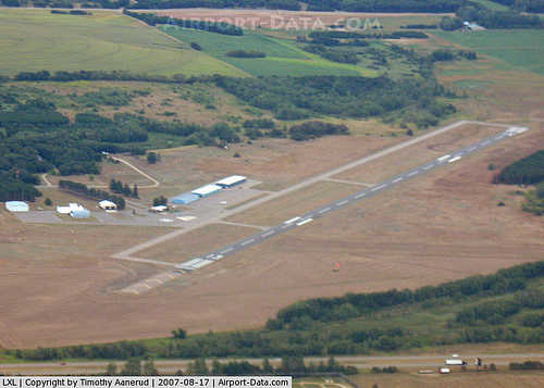 |
(Click on the photo to enlarge) |
Location & QuickFacts
| FAA Information Effective: | 2008-09-25 |
| Airport Identifier: | LXL |
| Airport Status: | Operational |
| Longitude/Latitude: | 094-20-49.4000W/45-56-57.9000N
-94.347056/45.949417 (Estimated) |
| Elevation: | 1123 ft / 342.29 m (Surveyed) |
| Land: | 290 acres |
| From nearest city: | 2 nautical miles S of Little Falls, MN |
| Location: | Morrison County, MN |
| Magnetic Variation: | 03E (1995) |
Owner & Manager
| Ownership: | Publicly owned |
| Owner: | City Little Falls/morrison Co |
| Address: | 100 Ne 7th Ave
Little Falls, MN 56345 |
| Phone number: | 320-632-2341 |
| Manager: | Tom Olson |
| Address: | 13129 Airport Road
Little Falls, MN 56345 |
| Phone number: | 320-632-0822 |
Airport Operations and Facilities
| Airport Use: | Open to public |
| Wind indicator: | Yes |
| Segmented Circle: | No |
| Control Tower: | No |
| Lighting Schedule: | DUSK-DAWN
ACTVT MIRL RY 13/31, PAPI & REIL RYS 13 & 31 - CTAF. |
| Beacon Color: | Clear-Green (lighted land airport) |
| Landing fee charge: | No |
| Sectional chart: | Twin Cities |
| Region: | AGL - Great Lakes |
| Boundary ARTCC: | ZMP - Minneapolis |
| Tie-in FSS: | PNM - Princeton |
| FSS on Airport: | No |
| FSS Toll Free: | 1-800-WX-BRIEF |
| NOTAMs Facility: | LXL (NOTAM-d service avaliable) |
| Federal Agreements: | NY1 |
Airport Communications
| CTAF: | 122.800 |
| Unicom: | 122.800 |
Airport Services
| Fuel available: | 100LL
FUEL AVAIL 24 HRS W CREDIT CARD. |
| Bottled Oxygen: | NONE |
| Bulk Oxygen: | NONE |
Runway Information
Runway 13/31
| Dimension: | 4011 x 77 ft / 1222.6 x 23.5 m
ADDITIONAL 500 FT OFF NW END RY 13/31 MARKED UNUSABLE. |
| Surface: | ASPH, Good Condition |
| Weight Limit: | Single wheel: 22000 lbs.
Dual wheel: 42000 lbs. |
| Edge Lights: | Medium |
| |
Runway 13 |
Runway 31 |
| Longitude: | 094-21-04.0047W | 094-20-20.9363W |
| Latitude: | 45-57-09.4239N | 45-56-43.6352N |
| Elevation: | 1119.00 ft | 1123.00 ft |
| Alignment: | 127 | 127 |
| Traffic Pattern: | Left | Left |
| Markings: | Non-precision instrument, Good Condition | Non-precision instrument, Good Condition |
| Crossing Height: | 25.00 ft | 25.00 ft |
| VASI: | 4-light PAPI on right side | 4-light PAPI on left side |
| Visual Glide Angle: | 3.00° | 3.00° |
| Runway End Identifier: | Yes | Yes |
| Centerline Lights: | No | No |
| Touchdown Lights: | No | No |
| Obstruction: | 77 ft trees, 2700.0 ft from runway, 32:1 slope to clear | , 50:1 slope to clear |
|
Runway 18/36
| Dimension: | 2922 x 170 ft / 890.6 x 51.8 m
ADDITIONAL 500 FT OFF NW END RY 13/31 MARKED UNUSABLE. |
| Surface: | TURF, Good Condition |
| |
Runway 18 |
Runway 36 |
| Longitude: | 094-20-55.3224W | 094-21-02.6903W |
| Latitude: | 45-57-13.9318N | 45-56-45.5541N |
| Elevation: | 1118.00 ft | 1110.00 ft |
| Alignment: | 127 | 11 |
| Traffic Pattern: | Left | Left |
| Displaced threshold: | 203.00 ft | 0.00 ft |
| Runway End Identifier: | No | No |
| Centerline Lights: | No | No |
| Touchdown Lights: | No | No |
| Obstruction: | 45 ft trees, 700.0 ft from runway, 110 ft right of centerline, 15:1 slope to clear
20:1 TO DISP THLD. | 24 ft trees, 800.0 ft from runway, 100 ft right of centerline, 33:1 slope to clear |
|
Radio Navigation Aids
| ID |
Type |
Name |
Ch |
Freq |
Var |
Dist |
| LXL | NDB | Little Falls | | 359.00 | 03E | 0.2 nm |
| XCR | NDB | Ripley | | 404.00 | 03E | 7.8 nm |
| SAZ | NDB | Staples | | 257.00 | 04E | 32.3 nm |
| PNM | NDB | Princeton | | 368.00 | 03E | 38.7 nm |
| EE | NDB | Tamie | | 374.00 | 04E | 41.2 nm |
| GHW | NDB | Glenwood | | 346.00 | 03E | 44.6 nm |
| JMR | NDB | Mora | | 327.00 | 03E | 45.3 nm |
| AIT | NDB | Aitkin | | 397.00 | 03E | 45.5 nm |
| PWC | NDB | Pine River | | 330.00 | 03E | 46.8 nm |
| RYM | TACAN | Camp Ripley | 048X | | 03E | 8.5 nm |
| STC | VOR/DME | St Cloud | 058X | 112.10 | 03E | 26.9 nm |
| AXN | VOR/DME | Alexandria | 075X | 112.80 | 07E | 37.0 nm |
| BRD | VORTAC | Brainerd | 116X | 116.90 | 03E | 27.4 nm |
Remarks
- AVOID MINK RANCH DEP RY 36; RANCH IS 1/2 MI NE OF RY.
- ULTRALIGHT TRAFFIC ON & INVOF ARPT.
- GCO AVBL ON FREQ 121.725 THRU MINNEAPOLIS ARTCC & FLT SVCS.
Images and information placed above are from
http://www.airport-data.com/airport/LXL/
We thank them for the data!
| General Info
|
| Country |
United States
|
| State |
MINNESOTA
|
| FAA ID |
LXL
|
| Latitude |
45-56-58.790N
|
| Longitude |
094-20-50.670W
|
| Elevation |
1122 feet
|
| Near City |
LITTLE FALLS
|
We don't guarantee the information is fresh and accurate. The data may
be wrong or outdated.
For more up-to-date information please refer to other sources.
|
|