 |
|
Litchfield Municipal Airport |
| Litchfield Municipal Airport |
| IATA: none – ICAO: KLJF – FAA LID: LJF |
| Summary |
| Airport type |
Public |
| Owner |
City of Litchfield |
| Serves |
Litchfield, Minnesota |
| Elevation AMSL |
1,140 ft / 347 m |
| Coordinates |
45°05′50″N 094°30′26″W / 45.09722°N 94.50722°W / 45.09722; -94.50722 |
| Runways |
| Direction |
Length |
Surface |
| ft |
m |
| 13/31 |
4,002 |
1,220 |
Asphalt |
| Statistics (2007) |
| Aircraft operations |
7,000 |
| Based aircraft |
30 |
| Sources: Minnesota DOT, FAA |
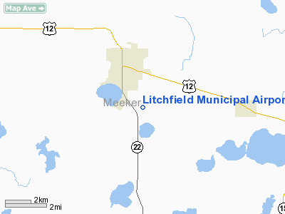
Litchfield Municipal Airport (ICAO: KLJF, FAA LID: LJF) is a city-owned public use airport located two nautical miles (3.7 km) southeast of the central business district of Litchfield, a city in Meeker County, Minnesota, United States.
Although most U.S. airports use the same three-letter location identifier for the FAA and IATA, this airport is assigned LJF by the FAA but has no designation from the IATA.
Facilities and aircraft
Litchfield Municipal Airport covers an area of 378 acres (153 ha) at an elevation of 1,140 feet (347 m) above mean sea level. It has one runway designated 13/31 with an asphalt surface measuring 4,002 by 100 feet (1,220 x 30 m).
For the 12-month period ending July 31, 2007, the airport had 7,000 aircraft operations, an average of 19 per day: 86% general aviation and 14% air taxi. At that time there were 30 aircraft based at this airport: 27 single-engine, 1 multi-engine, 1 helicopter and 1 ultralight.
The above content comes from Wikipedia and is published under free licenses – click here to read more.
Location & QuickFacts
| FAA Information Effective: | 2008-09-25 |
| Airport Identifier: | LJF |
| Airport Status: | Operational |
| Longitude/Latitude: | 094-30-26.1000W/45-05-49.7000N
-94.507250/45.097139 (Estimated) |
| Elevation: | 1140 ft / 347.47 m (Surveyed) |
| Land: | 378 acres |
| From nearest city: | 2 nautical miles SE of Litchfield, MN |
| Location: | Meeker County, MN |
| Magnetic Variation: | 06E (1975) |
Owner & Manager
| Ownership: | Publicly owned |
| Owner: | City Of Litchfield |
| Address: | P.o. Box 521
Litchfield, MN 55355 |
| Phone number: | 320-693-7201 |
| Manager: | Glenn E. Young |
| Address: | 703 Park Ave.
Litchfield, MN 55355 |
| Phone number: | 320-693-8571 |
Airport Operations and Facilities
| Airport Use: | Open to public |
| Wind indicator: | Yes |
| Segmented Circle: | No |
| Control Tower: | No |
| Lighting Schedule: | DUSK-DAWN
MIRL RY 13/31 PRESET ON LOW INTST, TO INCR INTST AND ACTVT PAPI RYS 13 & 31 AND REIL RYS 13 & 31 - CTAF. |
| Beacon Color: | Clear-Green (lighted land airport) |
| Sectional chart: | Twin Cities |
| Region: | AGL - Great Lakes |
| Boundary ARTCC: | ZMP - Minneapolis |
| Tie-in FSS: | PNM - Princeton |
| FSS Toll Free: | 1-800-WX-BRIEF |
| NOTAMs Facility: | LJF (NOTAM-d service avaliable) |
| Federal Agreements: | NGY |
Airport Communications
Airport Services
| Fuel available: | 100LLA
SELF SVC FUEL AVBL 24 HRS. |
Runway Information
Runway 13/31
| Dimension: | 4002 x 100 ft / 1219.8 x 30.5 m |
| Surface: | ASPH, Good Condition |
| Edge Lights: | Medium |
| |
Runway 13 |
Runway 31 |
| Longitude: | 094-30-44.6251W | 094-30-07.6266W |
| Latitude: | 45-06-04.4620N | 45-05-34.8870N |
| Elevation: | 1140.00 ft | 1140.00 ft |
| Alignment: | 127 | 127 |
| Traffic Pattern: | Left | Left |
| Markings: | Non-precision instrument, Good Condition | Non-precision instrument, Good Condition |
| Crossing Height: | 42.00 ft | 42.00 ft |
| VASI: | 4-light PAPI on left side | 4-light PAPI on left side |
| Visual Glide Angle: | 3.00° | 3.00° |
| Runway End Identifier: | Yes | Yes |
| Obstruction: | 46 ft trees, 1350.0 ft from runway, 100 ft right of centerline, 25:1 slope to clear | , 50:1 slope to clear |
|
Radio Navigation Aids
| ID |
Type |
Name |
Ch |
Freq |
Var |
Dist |
| HCD | NDB | Hutchinson | | 209.00 | 04E | 15.4 nm |
| GYL | NDB | Glencoe | | 407.00 | 03E | 27.0 nm |
| PNM | NDB | Princeton | | 368.00 | 03E | 47.3 nm |
| GHW | NDB | Glenwood | | 346.00 | 03E | 47.5 nm |
| ULM | NDB/DME | New Ulm | 050X | 272.00 | 04E | 46.8 nm |
| ILL | VOR/DME | Willmar | 084X | 113.70 | 04E | 24.8 nm |
| BDH | VOR/DME | Willmar | 84X | 113.70 | 04E | 26.3 nm |
| STC | VOR/DME | St Cloud | 058X | 112.10 | 03E | 33.1 nm |
| RWF | VOR/DME | Redwood Falls | 080X | 113.30 | 07E | 46.2 nm |
| FCM | VOR/DME | Flying Cloud | 055X | 111.80 | 06E | 47.6 nm |
| DWN | VORTAC | Darwin | 027X | 109.00 | 07E | 2.3 nm |
| GEP | VORTAC | Gopher | 120X | 117.30 | 06E | 48.2 nm |
Images and information placed above are from
http://www.airport-data.com/airport/LJF/
We thank them for the data!
| General Info
|
| Country |
United States
|
| State |
MINNESOTA
|
| FAA ID |
LJF
|
| Latitude |
45-05-49.664N
|
| Longitude |
094-30-26.166W
|
| Elevation |
1140 feet
|
| Near City |
LITCHFIELD
|
We don't guarantee the information is fresh and accurate. The data may
be wrong or outdated.
For more up-to-date information please refer to other sources.
|
|


