|
|
|
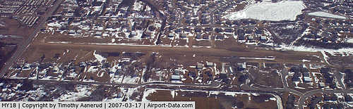 |
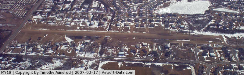
(Click on the photo to enlarge) |
Location & QuickFacts
| FAA Information Effective: | 2008-09-25 |
| Airport Identifier: | MY18 |
| Airport Status: | Operational |
| Longitude/Latitude: | 093-07-49.8030W/45-11-13.8780N
-93.130501/45.187188 (Estimated) |
| Elevation: | 907 ft / 276.45 m (Surveyed) |
| Land: | 0 acres |
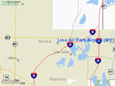
| From nearest city: | 2 nautical miles SW of Lino Lakes, MN |
| Location: | Anoka County, MN |
| Magnetic Variation: | 03E (1985) |
Owner & Manager
| Ownership: | Privately owned |
| Owner: | Lino Air Park Inc |
| Address: | 8383 4th Aveneue
Lino Lakes, MN 55014 |
| Phone number: | 612-786-4106 |
| Manager: | Clayton Wendt |
| Address: | 391 Thomas St
Lind Lakes, MN 55014 |
| Phone number: | 612-784-0480 |
Airport Operations and Facilities
| Airport Use: | Private |
| Wind indicator: | Yes |
| Segmented Circle: | No |
| Control Tower: | No |
| Lighting Schedule: | DUSK-0100 |
| Sectional chart: | Twin Cities |
| Region: | AGL - Great Lakes |
| Boundary ARTCC: | ZMP - Minneapolis |
| Tie-in FSS: | PNM - Princeton |
| FSS on Airport: | No |
| FSS Toll Free: | 1-800-WX-BRIEF |
Runway Information
Runway 09/27
| Dimension: | 2383 x 120 ft / 726.3 x 36.6 m |
| Surface: | TURF, Good Condition |
| Edge Lights: | Low |
| |
Runway 09 |
Runway 27 |
| Traffic Pattern: | Right | Left |
| Obstruction: | 21 ft trees, 150.0 ft from runway, 120 ft left of centerline, 7:1 slope to clear | 30 ft tree, 20.0 ft from runway, 90 ft right of centerline |
|
Radio Navigation Aids
| ID |
Type |
Name |
Ch |
Freq |
Var |
Dist |
| OEO | NDB | Osceola | | 233.00 | 01E | 20.1 nm |
| PPI | NDB | Hopey | | 400.00 | 03E | 20.5 nm |
| MS | NDB | Narco | | 266.00 | 02E | 21.8 nm |
| CBG | NDB | Cambridge | | 350.00 | 03E | 22.9 nm |
| RNH | NDB | New Richmond | | 257.00 | 02E | 25.4 nm |
| PNM | NDB | Princeton | | 368.00 | 03E | 30.3 nm |
| ROS | NDB | Rush City | | 282.00 | 02E | 31.5 nm |
| AHH | NDB | Ameron | | 278.00 | 01E | 32.6 nm |
| JMR | NDB | Mora | | 327.00 | 03E | 42.7 nm |
| GYL | NDB | Glencoe | | 407.00 | 03E | 48.0 nm |
| BXR | NDB | Big Doctor | | 203.00 | 02E | 49.9 nm |
| MSP | VOR/DME | Minneapolis | 100X | 115.30 | 02E | 18.0 nm |
| FCM | VOR/DME | Flying Cloud | 055X | 111.80 | 06E | 25.8 nm |
| STC | VOR/DME | St Cloud | 058X | 112.10 | 03E | 44.8 nm |
| RZN | VOR/DME | Siren | 031X | 109.40 | 02E | 49.6 nm |
| GEP | VORTAC | Gopher | 120X | 117.30 | 06E | 10.6 nm |
| FGT | VORTAC | Farmington | 104X | 115.70 | 06E | 33.5 nm |
| STP | VOT | St Paul | | 114.40 | | 15.1 nm |
| MSP | VOT | Minneapolis St Paul | | 111.00 | | 18.6 nm |
Remarks
- ALL TRAFFIC PATTERN OPERATIONS ARE CONDUCTED ON THE SOUTH SIDE OF RWY 09/27.
Images and information placed above are from
http://www.airport-data.com/airport/MY18/
We thank them for the data!
| General Info
|
| Country |
United States
|
| State |
MINNESOTA
|
| FAA ID |
MY18
|
| Latitude |
45-11-13.878N
|
| Longitude |
093-07-49.803W
|
| Elevation |
907 feet
|
| Near City |
LINO LAKES
|
We don't guarantee the information is fresh and accurate. The data may
be wrong or outdated.
For more up-to-date information please refer to other sources.
|
|