 |
|
| Lake Elmo Airport |
| IATA: none – ICAO: none – FAA LID: 21D |
| Summary |
| Airport type |
Public |
| Operator |
Metropolitan Airports Commission |
| Location |
Baytown Township, Washington County, near Lake Elmo, Minnesota |
| Elevation AMSL |
932 ft / 284.1 m |
| Coordinates |
44°59′51″N 92°51′20″W / 44.9975°N 92.85556°W / 44.9975; -92.85556Coordinates: 44°59′51″N 92°51′20″W / 44.9975°N 92.85556°W / 44.9975; -92.85556 |
| Runways |
| Direction |
Length |
Surface |
| ft |
m |
| 14/32 |
2,850 |
869 |
Asphalt |
| 4/22 |
2,497 |
761 |
Asphalt |
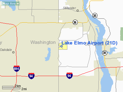
Lake Elmo Airport (FAA LID: 21D) is a public airport located just outside the city of Lake Elmo in Washington County, Minnesota, about 12 miles east of the central business district (CBD) of St. Paul. The airport covers 640 acres (259 ha) and has two runways. There are more than 54,000 takeoffs and landings annually, and 237 aircraft are based at the facility. It is also home to a Civil Air Patrol squadron. History
During World War II the airfield was used by the United States Army Air Force
The above content comes from Wikipedia and is published under free licenses – click here to read more.
Location & QuickFacts
| FAA Information Effective: | 2008-09-25 |
| Airport Identifier: | 21D |
| Airport Status: | Operational |
| Longitude/Latitude: | 092-51-20.4000W/44-59-51.0000N
-92.855667/44.997500 (Estimated) |
| Elevation: | 933 ft / 284.38 m (Surveyed) |
| Land: | 640 acres |
| From nearest city: | 9 nautical miles E of St Paul, MN |
| Location: | Washington County, MN |
| Magnetic Variation: | 04E (1980) |
Owner & Manager
| Ownership: | Publicly owned |
| Owner: | Metropolitan Airport Cmsn |
| Address: | 6040 28th Avenue So.
Minneapolis, MN 55450 |
| Phone number: | 612-726-1892 |
| Manager: | Greg Fries |
| Address: | 644 Bayfield St
St Paul, MN 55107 |
| Phone number: | 651-224-4306 |
Airport Operations and Facilities
| Airport Use: | Open to public |
| Wind indicator: | Yes |
| Segmented Circle: | No |
| Control Tower: | No |
| Lighting Schedule: | DUSK-DAWN
ACTVT REIL RYS 14 & 32 AND PAPI RY 32 - CTAF. |
| Beacon Color: | Clear-Green (lighted land airport) |
| Landing fee charge: | No |
| Sectional chart: | Green Bay |
| Region: | AGL - Great Lakes |
| Traffic Pattern Alt: | 1000 ft |
| Boundary ARTCC: | ZMP - Minneapolis |
| Tie-in FSS: | PNM - Princeton |
| FSS on Airport: | No |
| FSS Toll Free: | 1-800-WX-BRIEF |
| NOTAMs Facility: | 21D (NOTAM-d service avaliable) |
| Federal Agreements: | NGY |
Airport Communications
| CTAF: | 122.800 |
| Unicom: | 122.800 |
Airport Services
| Fuel available: | 100LL
SELF SVC FUEL AVBL 24 HR WITH CREDIT CARD. |
| Airframe Repair: | MAJOR |
| Power Plant Repair: | MAJOR |
| Bottled Oxygen: | NONE |
| Bulk Oxygen: | NONE |
Runway Information
Runway 04/22
| Dimension: | 2497 x 75 ft / 761.1 x 22.9 m |
| Surface: | ASPH, Good Condition |
| Weight Limit: | Single wheel: 13000 lbs. |
| |
Runway 04 |
Runway 22 |
| Longitude: | 092-51-25.4993W | 092-51-03.4902W |
| Latitude: | 44-59-44.6620N | 45-00-03.7743N |
| Elevation: | 924.00 ft | 933.00 ft |
| Alignment: | 39 | 127 |
| Traffic Pattern: | Left | Left |
| Markings: | Non-precision instrument, Good Condition | Basic, Good Condition |
| Obstruction: | 82 ft tree, 1850.0 ft from runway, 230 ft right of centerline, 20:1 slope to clear | 77 ft trees, 2600.0 ft from runway, 31:1 slope to clear |
|
Runway 14/32
| Dimension: | 2850 x 75 ft / 868.7 x 22.9 m |
| Surface: | ASPH, Good Condition |
| Weight Limit: | Single wheel: 11000 lbs. |
| Edge Lights: | Medium |
| |
Runway 14 |
Runway 32 |
| Longitude: | 092-51-39.0735W | 092-51-12.2854W |
| Latitude: | 44-59-58.4904N | 44-59-37.7487N |
| Elevation: | 923.00 ft | 926.00 ft |
| Alignment: | 127 | 127 |
| Traffic Pattern: | Left | Left |
| Markings: | Non-precision instrument, Good Condition | Basic, Good Condition |
| Crossing Height: | 0.00 ft | 26.00 ft |
| VASI: | | 4-light PAPI on right side |
| Visual Glide Angle: | 0.00° | 3.00° |
| Runway End Identifier: | Yes | Yes |
| Obstruction: | 35 ft pline, 900.0 ft from runway, 50 ft left of centerline, 20:1 slope to clear | 25 ft road, 320.0 ft from runway, 190 ft right of centerline, 8:1 slope to clear
25 FT TREES 140-200 FT 190 FT R. |
|
Radio Navigation Aids
| ID |
Type |
Name |
Ch |
Freq |
Var |
Dist |
| PPI | NDB | Hopey | | 400.00 | 03E | 8.3 nm |
| MS | NDB | Narco | | 266.00 | 02E | 14.4 nm |
| RNH | NDB | New Richmond | | 257.00 | 02E | 16.4 nm |
| OEO | NDB | Osceola | | 233.00 | 01E | 20.1 nm |
| AHH | NDB | Ameron | | 278.00 | 01E | 26.7 nm |
| CBG | NDB | Cambridge | | 350.00 | 03E | 37.8 nm |
| ROS | NDB | Rush City | | 282.00 | 02E | 42.2 nm |
| PNM | NDB | Princeton | | 368.00 | 03E | 46.6 nm |
| UBE | NDB | Cumberland | | 375.00 | 01E | 48.3 nm |
| MSP | VOR/DME | Minneapolis | 100X | 115.30 | 02E | 17.3 nm |
| FCM | VOR/DME | Flying Cloud | 055X | 111.80 | 06E | 27.6 nm |
| GEP | VORTAC | Gopher | 120X | 117.30 | 06E | 23.7 nm |
| FGT | VORTAC | Farmington | 104X | 115.70 | 06E | 26.1 nm |
| STP | VOT | St Paul | | 114.40 | | 9.3 nm |
| MSP | VOT | Minneapolis St Paul | | 111.00 | | 16.7 nm |
Remarks
- ULTRALIGHT TRAFFIC PROHIBITED.
Images and information placed above are from
http://www.airport-data.com/airport/21D/
We thank them for the data!
| General Info
|
| Country |
United States
|
| State |
MINNESOTA
|
| FAA ID |
21D
|
| Latitude |
44-59-50.959N
|
| Longitude |
092-51-20.452W
|
| Elevation |
932 feet
|
| Near City |
ST PAUL
|
We don't guarantee the information is fresh and accurate. The data may
be wrong or outdated.
For more up-to-date information please refer to other sources.
|
|


