 |
|
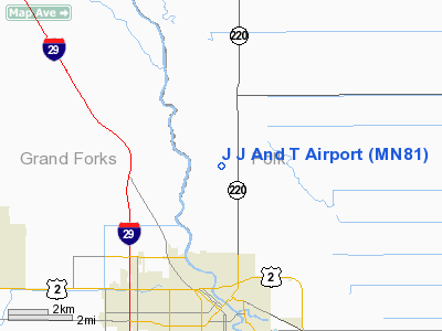
Location & QuickFacts
| FAA Information Effective: | 2008-09-25 |
| Airport Identifier: | MN81 |
| Airport Status: | Operational |
| Longitude/Latitude: | 097-01-52.2690W/47-59-19.9270N
-97.031186/47.988869 (Estimated) |
| Elevation: | 828 ft / 252.37 m (Estimated) |
| Land: | 0 acres |
| From nearest city: | 4 nautical miles S of East Grand Forks, MN |
| Location: | Polk County, MN |
| Magnetic Variation: | 07E (1985) |
Owner & Manager
| Ownership: | Privately owned |
| Owner: | John P Jenson |
| Address: | 2016 4th Ave N
Grand Forks, ND 58201 |
| Phone number: | 701-772-6510 |
| Address: |
|
Airport Operations and Facilities
| Airport Use: | Private
PERSONAL USE. |
| Segmented Circle: | No |
| Control Tower: | No |
| Sectional chart: | Twin Cities |
| Region: | AGL - Great Lakes |
| Boundary ARTCC: | ZMP - Minneapolis |
| Tie-in FSS: | PNM - Princeton |
| FSS on Airport: | No |
| FSS Toll Free: | 1-800-WX-BRIEF |
Runway Information
Runway 17/35
| Dimension: | 2600 x 80 ft / 792.5 x 24.4 m |
| Surface: | TURF, |
| |
Runway 17 |
Runway 35 |
| Traffic Pattern: | Left | Left |
|
Radio Navigation Aids
| ID |
Type |
Name |
Ch |
Freq |
Var |
Dist |
| CKN | NDB | Crookston | | 400.00 | 07E | 19.0 nm |
| RDR | TACAN | Red River | 111X | | 06E | 15.2 nm |
| GFK | VOR/DME | Grand Forks | 090X | 114.30 | 09E | 6.5 nm |
| TVF | VOR/DME | Thief River Falls | 021X | 108.40 | 08E | 34.3 nm |
Images and information placed above are from
http://www.airport-data.com/airport/MN81/
We thank them for the data!
| General Info
|
| Country |
United States
|
| State |
MINNESOTA
|
| FAA ID |
MN81
|
| Latitude |
47-59-19.927N
|
| Longitude |
097-01-52.269W
|
| Elevation |
828 feet
|
| Near City |
EAST GRAND FORKS
|
We don't guarantee the information is fresh and accurate. The data may
be wrong or outdated.
For more up-to-date information please refer to other sources.
|
|


