 |
|
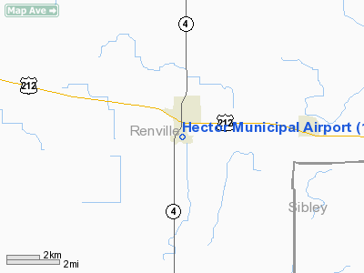
Location & QuickFacts
| FAA Information Effective: | 2008-09-25 |
| Airport Identifier: | 1D6 |
| Airport Status: | Operational |
| Longitude/Latitude: | 094-42-52.9680W/44-43-51.8620N
-94.714713/44.731073 (Estimated) |
| Elevation: | 1077 ft / 328.27 m (Surveyed) |
| Land: | 155 acres |
| From nearest city: | 1 nautical miles S of Hector, MN |
| Location: | Renville County, MN |
| Magnetic Variation: | 04E (1985) |
Owner & Manager
| Ownership: | Publicly owned |
| Owner: | City Of Hector |
| Address: | 301 Main St
Hector, MN 55342 |
| Phone number: | 320-848-2122 |
| Manager: | Edgar Newberg |
| Address: | 78980 St Hwy 4 South
Hector, MN 55342 |
| Phone number: | 320-848-2745 |
Airport Operations and Facilities
| Airport Use: | Open to public |
| Wind indicator: | Yes |
| Segmented Circle: | No |
| Control Tower: | No |
| Lighting Schedule: | DUSK-DAWN |
| Landing fee charge: | No |
| Sectional chart: | Twin Cities |
| Region: | AGL - Great Lakes |
| Boundary ARTCC: | ZMP - Minneapolis |
| Tie-in FSS: | PNM - Princeton |
| FSS on Airport: | No |
| FSS Toll Free: | 1-800-WX-BRIEF |
| NOTAMs Facility: | PNM (NOTAM-d service avaliable) |
| Federal Agreements: | NY1 |
Airport Communications
| CTAF: | 122.800 |
| Unicom: | 122.800 |
Airport Services
| Fuel available: | 100LL |
| Airframe Repair: | NONE |
| Power Plant Repair: | NONE |
| Bottled Oxygen: | NONE |
| Bulk Oxygen: | NONE |
Runway Information
Runway 05/23
| Dimension: | 2580 x 165 ft / 786.4 x 50.3 m |
| Surface: | TURF, Fair Condition |
| |
Runway 05 |
Runway 23 |
| Traffic Pattern: | Left | Left |
| Markings: | None,
05/23 MKD WITH YELLOW CONES. | None, |
| Runway End Identifier: | No | No |
| Centerline Lights: | No | No |
| Touchdown Lights: | No | No |
| Obstruction: | 17 ft road, 378.0 ft from runway, 163 ft left of centerline, 22:1 slope to clear | , 50:1 slope to clear |
|
Runway 12/30
| Dimension: | 2776 x 50 ft / 846.1 x 15.2 m |
| Surface: | ASPH, Good Condition |
| Weight Limit: | Single wheel: 13000 lbs.
Dual wheel: 18000 lbs. |
| Edge Lights: | Non-standard lighting system
NSTD LGTS MOUNTED IN YELLOW CONES. |
| |
Runway 12 |
Runway 30 |
| Longitude: | 094-42-54.0800W | 094-42-27.2700W |
| Latitude: | 44-43-58.1400N | 44-43-44.3000N |
| Elevation: | 1078.00 ft | 1077.00 ft |
| Traffic Pattern: | Left | Left |
| Markings: | Basic, Good Condition | Basic, Good Condition |
| Runway End Identifier: | No | No |
| Centerline Lights: | No | No |
| Touchdown Lights: | No | No |
| Obstruction: | 15 ft road, 500.0 ft from runway, 150 ft right of centerline, 20:1 slope to clear | , 50:1 slope to clear |
|
Radio Navigation Aids
| ID |
Type |
Name |
Ch |
Freq |
Var |
Dist |
| HCD | NDB | Hutchinson | | 209.00 | 04E | 16.0 nm |
| GYL | NDB | Glencoe | | 407.00 | 03E | 26.9 nm |
| JYG | NDB | St James | | 260.00 | 04E | 45.4 nm |
| ULM | NDB/DME | New Ulm | 050X | 272.00 | 04E | 26.5 nm |
| RWF | VOR/DME | Redwood Falls | 080X | 113.30 | 07E | 23.8 nm |
| ILL | VOR/DME | Willmar | 084X | 113.70 | 04E | 28.2 nm |
| BDH | VOR/DME | Willmar | 84X | 113.70 | 04E | 29.1 nm |
| MVE | VOR/DME | Montevideo | 053X | 111.60 | 05E | 44.9 nm |
| MKT | VOR/DME | Mankato | 045X | 110.80 | 07E | 46.1 nm |
| DWN | VORTAC | Darwin | 027X | 109.00 | 07E | 24.1 nm |
Remarks
- ULTRALIGHT TRAFFIC ON & INVOF AIRPORT.
Images and information placed above are from
http://www.airport-data.com/airport/1D6/
We thank them for the data!
| General Info
|
| Country |
United States
|
| State |
MINNESOTA
|
| FAA ID |
1D6
|
| Latitude |
44-43-51.862N
|
| Longitude |
094-42-52.968W
|
| Elevation |
1077 feet
|
| Near City |
HECTOR
|
We don't guarantee the information is fresh and accurate. The data may
be wrong or outdated.
For more up-to-date information please refer to other sources.
|
|


