 |
|
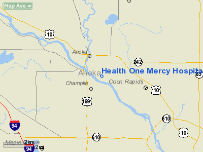
Health One Mercy Hospital Heliport |
Location & QuickFacts
| FAA Information Effective: | 2008-09-25 |
| Airport Identifier: | MN07 |
| Airport Status: | Operational |
| Longitude/Latitude: | 093-22-12.8300W/45-11-00.8740N
-93.370231/45.183576 (Estimated) |
| Elevation: | 867 ft / 264.26 m (Estimated) |
| Land: | 0 acres |
| From nearest city: | 0 nautical miles N of Anoka, MN |
| Location: | Anoka County, MN |
| Magnetic Variation: | 03E (1985) |
Owner & Manager
| Ownership: | Privately owned |
| Owner: | Allina, Mercy Hospital |
| Address: | 4050 Coon Rapids Blvd
Coon Rapids, MN 55433 |
| Phone number: | 763-236-7095 |
| Manager: | Director Of Support Service |
| Address: | 4050 Coon Rapids Blvd
Coon Rapids, MN 55433 |
| Phone number: | 763-236-7095 |
Airport Operations and Facilities
| Airport Use: | Private
MEDICAL USE. |
| Wind indicator: | Yes |
| Segmented Circle: | Yes |
| Control Tower: | No |
| Landing fee charge: | No |
| Sectional chart: | Twin Cities |
| Region: | AGL - Great Lakes |
| Boundary ARTCC: | ZMP - Minneapolis |
| Tie-in FSS: | PNM - Princeton |
| FSS on Airport: | No |
| FSS Toll Free: | 1-800-WX-BRIEF |
Airport Services
| Airframe Repair: | NONE |
| Power Plant Repair: | NONE |
Runway Information
Helipad H1
| Dimension: | 30 x 30 ft / 9.1 x 9.1 m |
| Surface: | CONC, |
| |
Runway H1 |
Runway |
| Traffic Pattern: | Left | Left |
|
Radio Navigation Aids
| ID |
Type |
Name |
Ch |
Freq |
Var |
Dist |
| CBG | NDB | Cambridge | | 350.00 | 03E | 22.9 nm |
| MS | NDB | Narco | | 266.00 | 02E | 24.6 nm |
| PNM | NDB | Princeton | | 368.00 | 03E | 25.0 nm |
| PPI | NDB | Hopey | | 400.00 | 03E | 26.1 nm |
| OEO | NDB | Osceola | | 233.00 | 01E | 29.9 nm |
| ROS | NDB | Rush City | | 282.00 | 02E | 35.5 nm |
| RNH | NDB | New Richmond | | 257.00 | 02E | 35.5 nm |
| GYL | NDB | Glencoe | | 407.00 | 03E | 39.6 nm |
| AHH | NDB | Ameron | | 278.00 | 01E | 42.7 nm |
| JMR | NDB | Mora | | 327.00 | 03E | 42.7 nm |
| HCD | NDB | Hutchinson | | 209.00 | 04E | 47.3 nm |
| MSP | VOR/DME | Minneapolis | 100X | 115.30 | 02E | 18.2 nm |
| FCM | VOR/DME | Flying Cloud | 055X | 111.80 | 06E | 21.8 nm |
| STC | VOR/DME | St Cloud | 058X | 112.10 | 03E | 36.4 nm |
| GEP | VORTAC | Gopher | 120X | 117.30 | 06E | 2.3 nm |
| FGT | VORTAC | Farmington | 104X | 115.70 | 06E | 34.2 nm |
| DWN | VORTAC | Darwin | 027X | 109.00 | 07E | 46.3 nm |
| MSP | VOT | Minneapolis St Paul | | 111.00 | | 19.2 nm |
| STP | VOT | St Paul | | 114.40 | | 19.7 nm |
Images and information placed above are from
http://www.airport-data.com/airport/MN07/
We thank them for the data!
| General Info
|
| Country |
United States
|
| State |
MINNESOTA
|
| FAA ID |
MN07
|
| Latitude |
45-11-00.874N
|
| Longitude |
093-22-12.830W
|
| Elevation |
867 feet
|
| Near City |
ANOKA
|
We don't guarantee the information is fresh and accurate. The data may
be wrong or outdated.
For more up-to-date information please refer to other sources.
|
|


