 |
|
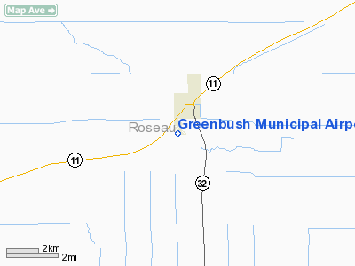
Greenbush Municipal Airport |
Location & QuickFacts
| FAA Information Effective: | 2008-09-25 |
| Airport Identifier: | 02MN |
| Airport Status: | Operational |
| Longitude/Latitude: | 096-11-31.0570W/48-40-59.9150N
-96.191960/48.683310 (Estimated) |
| Elevation: | 1070 ft / 326.14 m (Estimated) |
| Land: | 80 acres |
| From nearest city: | 0 nautical miles SW of Greenbush, MN |
| Location: | Roseau County, MN |
| Magnetic Variation: | 05E (1985) |
Owner & Manager
| Ownership: | Publicly owned |
| Owner: | City Of Greenbush |
| Address: |
Greenbush, MN 56726 |
| Phone number: | 218-782-2570 |
| Manager: | Anita Locken |
| Address: |
Greenbush, MN 56726 |
| Phone number: | 218-782-2570 |
Airport Operations and Facilities
| Airport Use: | Private |
| Wind indicator: | Yes |
| Segmented Circle: | No |
| Control Tower: | No |
| Landing fee charge: | No |
| Sectional chart: | Twin Cities |
| Region: | AGL - Great Lakes |
| Boundary ARTCC: | ZMP - Minneapolis |
| Tie-in FSS: | PNM - Princeton |
| FSS on Airport: | No |
| FSS Toll Free: | 1-800-WX-BRIEF |
Airport Services
| Airframe Repair: | NONE |
| Power Plant Repair: | NONE |
| Bottled Oxygen: | NONE |
| Bulk Oxygen: | NONE |
Runway Information
Runway 03/21
| Dimension: | 1897 x 192 ft / 578.2 x 58.5 m |
| Surface: | TURF, Poor Condition
HAS TALL GRASS & BUMPY.
HAS TALL GRASS AN HAS MANY MARKERS MISSING.
IS RUTTED; UNEVEN & BUMPY. |
| |
Runway 03 |
Runway 21 |
| Traffic Pattern: | Left | Left |
| Obstruction: | 30 ft pole, 300.0 ft from runway, 120 ft right of centerline, 10:1 slope to clear | 44 ft trees, 130.0 ft from runway, 120 ft right of centerline, 2:1 slope to clear |
|
Runway 12/30
| Dimension: | 2500 x 192 ft / 762.0 x 58.5 m |
| Surface: | TURF, Fair Condition
HAS TALL GRASS & BUMPY.
HAS TALL GRASS AN HAS MANY MARKERS MISSING.
IS RUTTED; UNEVEN & BUMPY. |
| |
Runway 12 |
Runway 30 |
| Traffic Pattern: | Left | Left |
| Obstruction: | 46 ft trees, 230.0 ft from runway, 80 ft right of centerline, 5:1 slope to clear | 15 ft tree, 195.0 ft from runway, 120 ft right of centerline, 13:1 slope to clear |
|
Runway 13/31
| Dimension: | 2553 x 82 ft / 778.2 x 25.0 m |
| Surface: | TURF, Poor Condition
HAS TALL GRASS & BUMPY.
HAS TALL GRASS AN HAS MANY MARKERS MISSING.
IS RUTTED; UNEVEN & BUMPY. |
| |
Runway 13 |
Runway 31 |
| Traffic Pattern: | Left | Left |
| Obstruction: | 50 ft trees, 500.0 ft from runway, 10:1 slope to clear | , 50:1 slope to clear |
|
Radio Navigation Aids
| ID |
Type |
Name |
Ch |
Freq |
Var |
Dist |
| PFT | NDB | Piney Pinecreek | | 342.00 | 05E | 20.4 nm |
| ROX | VOR/DME | Roseau | 025X | 108.80 | 05E | 22.2 nm |
| TVF | VOR/DME | Thief River Falls | 021X | 108.40 | 08E | 36.9 nm |
| HML | VORTAC | Humboldt | 071X | 112.40 | 09E | 38.3 nm |
Remarks
- RWYS NOT PLOWED WINTER MONTHS.
- (E62-03) LANDING LENGTH BASED ON 20:1 APCH RATIO.
- (E62-12) LANDING LENGTH BASED ON 20:1 APCH RATIO.
- (E62-21) LANDING LENGTH BASED ON 20:1 APCH RATIO.
- (E62-30) LANDING LENGTH BASED ON 20:1 APCH RATIO.
Images and information placed above are from
http://www.airport-data.com/airport/02MN/
We thank them for the data!
| General Info
|
| Country |
United States
|
| State |
MINNESOTA
|
| FAA ID |
02MN
|
| Latitude |
48-40-59.915N
|
| Longitude |
096-11-31.057W
|
| Elevation |
1070 feet
|
| Near City |
GREENBUSH
|
We don't guarantee the information is fresh and accurate. The data may
be wrong or outdated.
For more up-to-date information please refer to other sources.
|
|


