 |
|
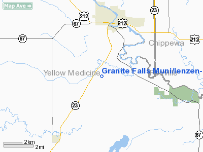
Granite Falls Muni/lenzen-roe Memorial Fld Airport |
Granite Falls Municipal Airport
Lenzen-Roe Memorial Field |
| IATA: none – ICAO: KGDB – FAA LID: GDB |
| Summary |
| Airport type |
Public |
| Owner |
City of Granite Falls |
| Serves |
Granite Falls, Minnesota |
| Elevation AMSL |
1,047 ft / 319 m |
| Coordinates |
44°45′12″N 095°33′22″W / 44.75333°N 95.55611°W / 44.75333; -95.55611 |
| Website |
GraniteFalls.com/... |
| Runways |
| Direction |
Length |
Surface |
| ft |
m |
| 15/33 |
4,350 |
1,326 |
Asphalt |
| Statistics (2006) |
| Aircraft operations |
7,000 |
| Based aircraft |
15 |
| Sources: Minnesota DOT, FAA |
Granite Falls Municipal Airport (ICAO: KGDB, FAA LID: GDB, formerly 1G2), also known as Lenzen-Roe Memorial Field, is a public-use airport in Yellow Medicine County, Minnesota, United States. It is owned by the City of Granite Falls and located four nautical miles (7 km) south of its central business district. The airport is situated near State Highway 23.
Although most U.S. airports use the same three-letter location identifier for the FAA and IATA, this airport is assigned GDB by the FAA but has no designation from the IATA
Facilities and aircraft
The airport covers an area of 152 acres (62 ha) at an elevation of 1,047 feet (319 m) above mean sea level. It has one runway designated 15/33 with an asphalt surface measuring 4,350 by 75 feet (1,326 x 23 m).
For the 12-month period ending August 31, 2006, the airport had 7,000 general aviation aircraft operations, an average of 19 per day. At that time there were 15 aircraft based at this airport: 11 single-engine, 2 multi-engine and 2 jet.
The above content comes from Wikipedia and is published under free licenses – click here to read more.
Location & QuickFacts
| FAA Information Effective: | 2008-09-25 |
| Airport Identifier: | GDB |
| Airport Status: | Operational |
| Longitude/Latitude: | 095-33-21.6615W/44-45-11.8150N
-95.556017/44.753282 (Estimated) |
| Elevation: | 1047 ft / 319.13 m (Estimated) |
| Land: | 152 acres |
| From nearest city: | 4 nautical miles S of Granite Falls, MN |
| Location: | Yellow Medicine County, MN |
| Magnetic Variation: | 04E (2000) |
Owner & Manager
| Ownership: | Publicly owned |
| Owner: | City Of Granite Falls |
| Address: | 885 Prentice St
Granite Falls, MN 56241 |
| Phone number: | 320-564-3011 |
| Manager: | Erik Hokuf |
| Address: | Po Box 159
Granite Falls, MN 56241 |
| Phone number: | 320-564-5665 |
Airport Operations and Facilities
| Airport Use: | Open to public |
| Wind indicator: | Yes |
| Segmented Circle: | No |
| Control Tower: | No |
| Lighting Schedule: | DUSK-DAWN
MIRL RY 15/33 PRESET ON LOW INTST DUSK TO DAWN; TO INCR INTST & ACTVT REIL RY 33 - CTAF. |
| Beacon Color: | Clear-Green (lighted land airport) |
| Sectional chart: | Twin Cities |
| Region: | AGL - Great Lakes |
| Boundary ARTCC: | ZMP - Minneapolis |
| Tie-in FSS: | PNM - Princeton |
| FSS on Airport: | No |
| FSS Toll Free: | 1-800-WX-BRIEF |
| NOTAMs Facility: | GDB (NOTAM-d service avaliable) |
Airport Communications
| CTAF: | 122.800 |
| Unicom: | 122.800 |
Airport Services
| Fuel available: | 100LL
SELF SERVICE FUEL AVAIL 24 HOURS WITH CREDIT CARD. |
Runway Information
Runway 15/33
| Dimension: | 4350 x 75 ft / 1325.9 x 22.9 m |
| Surface: | ASPH, Good Condition |
| Edge Lights: | Medium |
| |
Runway 15 |
Runway 33 |
| Longitude: | 095-33-31.6680W | 095-33-08.1845W |
| Latitude: | 44-45-28.6710N | 44-44-49.1123N |
| Elevation: | 1047.00 ft | 0.00 ft |
| Alignment: | 127 | 127 |
| Traffic Pattern: | Left | Left |
| Markings: | Non-precision instrument, Good Condition | Non-precision instrument, Good Condition |
| Displaced threshold: | 0.00 ft | 650.00 ft |
| Runway End Identifier: | | Yes |
| Obstruction: | 42 ft trees, 1600.0 ft from runway, 250 ft left of centerline, 33:1 slope to clear | 20 ft road, 230.0 ft from runway, 250 ft left of centerline, 1:1 slope to clear
ROAD +18, 880' FM DISPLACED THRESHOLD, 250 R, 37:1. |
|
Radio Navigation Aids
| ID |
Type |
Name |
Ch |
Freq |
Var |
Dist |
| DXX | NDB | Dawson/madison | | 341.00 | 06E | 30.0 nm |
| AQP | NDB | Appleton | | 356.00 | 05E | 34.5 nm |
| BBB | NDB | Benson | | 239.00 | 05E | 34.7 nm |
| VVV | NDB | Ortonville | | 332.00 | 05E | 49.4 nm |
| MVE | VOR/DME | Montevideo | 053X | 111.60 | 05E | 14.8 nm |
| MML | VOR/DME | Marshall | 047X | 111.00 | 05E | 21.6 nm |
| RWF | VOR/DME | Redwood Falls | 080X | 113.30 | 07E | 25.1 nm |
| BDH | VOR/DME | Willmar | 84X | 113.70 | 04E | 28.5 nm |
| ILL | VOR/DME | Willmar | 084X | 113.70 | 04E | 29.5 nm |
Remarks
- DEER ON & INVOF AIRPORT.
- NOISE SENSITIVE AREA 1.5 MI IN RADIUS OFF NORTH END OF RWY 15/33.
Images and information placed above are from
http://www.airport-data.com/airport/GDB/
We thank them for the data!
| General Info
| |
| Country |
United States
|
| State |
MINNESOTA
|
| FAA ID |
GDB
|
| Latitude |
44-45-11.815N
|
| Longitude |
095-33-21.661W
|
| Elevation |
1047 feet
|
| Near City |
GRANITE FALLS
|
We don't guarantee the information is fresh and accurate. The data may
be wrong or outdated.
For more up-to-date information please refer to other sources.
|
|


