 |
|
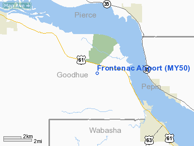
Location & QuickFacts
| FAA Information Effective: | 2008-09-25 |
| Airport Identifier: | MY50 |
| Airport Status: | Operational |
| Longitude/Latitude: | 092-21-40.6540W/44-30-09.8830N
-92.361293/44.502745 (Estimated) |
| Elevation: | 793 ft / 241.71 m (Estimated) |
| Land: | 3 acres |
| From nearest city: | 1 nautical miles S of Frontenac, MN |
| Location: | Goodhue County, MN |
| Magnetic Variation: | 02E (1985) |
Owner & Manager
| Ownership: | Privately owned |
| Owner: | Larry Getchell |
| Address: | 29476 Lake Ave.
Frontenac, MN 55026 |
| Phone number: | 612-345-4882 |
| Address: |
|
Airport Operations and Facilities
| Airport Use: | Private
PERSONAL USE. |
| Wind indicator: | Yes |
| Segmented Circle: | No |
| Control Tower: | No |
| Sectional chart: | Twin Cities |
| Region: | AGL - Great Lakes |
| Boundary ARTCC: | ZMP - Minneapolis |
| Tie-in FSS: | PNM - Princeton |
| FSS on Airport: | No |
| FSS Toll Free: | 1-800-WX-BRIEF |
Runway Information
Runway 13/31
| Dimension: | 2000 x 60 ft / 609.6 x 18.3 m |
| Surface: | TURF, |
| |
Runway 13 |
Runway 31 |
| Traffic Pattern: | Left | Left |
| Obstruction: | 15 ft road, 500.0 ft from runway
ROAD 15' ABOVE GRADE OBSTN.
POWERLINES 1000' FM RWY END. | 25 ft trees, 500.0 ft from runway |
|
Radio Navigation Aids
| ID |
Type |
Name |
Ch |
Freq |
Var |
Dist |
| PPI | NDB | Hopey | | 400.00 | 03E | 33.3 nm |
| MS | NDB | Narco | | 266.00 | 02E | 36.8 nm |
| RNH | NDB | New Richmond | | 257.00 | 02E | 39.4 nm |
| AHH | NDB | Ameron | | 278.00 | 01E | 46.8 nm |
| ONA | VOR/DME | Winona | 051X | 111.40 | 01E | 38.1 nm |
| MSP | VOR/DME | Minneapolis | 100X | 115.30 | 02E | 44.3 nm |
| RST | VOR/DME | Rochester | 057X | 112.00 | 05E | 44.4 nm |
| FOW | VOR/DME | Halfway | 049X | 111.20 | 02E | 46.9 nm |
| FGT | VORTAC | Farmington | 104X | 115.70 | 06E | 36.0 nm |
| EAU | VORTAC | Eau Claire | 076X | 112.90 | 04E | 44.6 nm |
| STP | VOT | St Paul | | 114.40 | | 39.8 nm |
| MSP | VOT | Minneapolis St Paul | | 111.00 | | 43.1 nm |
Images and information placed above are from
http://www.airport-data.com/airport/MY50/
We thank them for the data!
| General Info
|
| Country |
United States
|
| State |
MINNESOTA
|
| FAA ID |
MY50
|
| Latitude |
44-30-09.883N
|
| Longitude |
092-21-40.654W
|
| Elevation |
793 feet
|
| Near City |
FRONTENAC
|
We don't guarantee the information is fresh and accurate. The data may
be wrong or outdated.
For more up-to-date information please refer to other sources.
|
|


